


la Bérarde/source du Vénéon version courte

geoffrayLayeux
Utilisateur
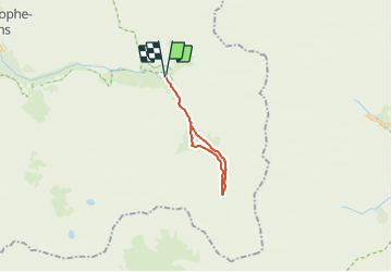

Longueur
14,9 km

Altitude max
2160 m

Dénivelé positif
490 m
Km-Effort
21 km

Altitude min
1714 m

Dénivelé négatif
490 m
Boucle
Oui
Date de création :
2021-06-26 11:10:40.591
Dernière modification :
2021-06-26 11:12:07.299
4h51
Difficulté : Très difficile

Application GPS de randonnée GRATUITE
 SityTrail
IGN / Instituts géographiques
SityTrail Plus
Le monde est à vous
À propos
Randonnée Marche de 14,9 km à découvrir à Auvergne-Rhône-Alpes, Isère, Saint-Christophe-en-Oisans. Cette randonnée est proposée par geoffrayLayeux.
Localisation
Pays :
France
Région :
Auvergne-Rhône-Alpes
Département/Province :
Isère
Commune :
Saint-Christophe-en-Oisans
Localité :
Unknown
Départ:(Dec)
Départ:(UTM)
286396 ; 4979019 (32T) N.
Commentaires