Randonnée Marche Saint-Hubert - Mirwart - Chevaldot (SH30) - Photo

Mirwart - Chevaldot (SH30)

Randonnées de la Grande Forêt de Saint-Hubert GUIDE+

© OpenStreetMap contributors
Longueur
Longueur
9 km
Altitude max
Altitude max
436 m
Dénivelé positif
Dénivelé positif
272 m
Km-Effort
Km-Effort  
12,7 km
Altitude min
Altitude min
248 m
Dénivelé négatif
Dénivelé négatif
273 m
Boucle
Boucle
Oui
Balise
Balise
Date de création :
2017-10-31 00:00:00.0
Dernière modification :
2017-10-31 00:00:00.0

(2 Avis)

Marche
Marche
2h42
Difficulté : Moyen

Scannez ce code QR pour ouvrir la randonnée dans l'application SityTrail

Application GPS de randonnée GRATUITE

Logo SityTrail SityTrail

IGN / Instituts géographiques

Télécharger SityTrail sur l'App Store Télécharger SityTrail sur Google Play

Logo SityTrail SityTrail World

Le monde est à vous

Télécharger SityTrail sur l'App Store Télécharger SityTrail sur Google Play Télécharger SityTrail sur Huawei AppGallery

À propos

Randonnée Marche de 9 km à découvrir à Wallonie, Luxembourg, Saint-Hubert. Cette randonnée est proposée par La Grande Forêt de Saint-Hubert.

Description

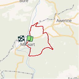
Cette balade forestière, au départ de l'église de Mirwart vous mènera à Blanche Virée, point culminant du domaine provincial de Mirwart, à une altitude de 427m.

Extrait de la carte de promenade « Au Pays de Saint-Hubert » (30 balades pédestres, 6 circuits VTT – carte topographique 1/25.000) disponible au Royal Syndicat d’Initiative de Saint-Hubert au prix de 8€.

Royal Syndicat d’Initiative de Saint-Hubert
Place du Marché, n°15
B-6870 SAINT-HUBERT
Tél.:  32 (0)61 61 30 10
Fax:  32 (0)61 61 54 44
rsi@saint-hubert-tourisme.be
www.rsi-sainthubert.be
facebook.com/rsisainthubert

Profil altimétrique

Photos

Points d'intérêt

Point d'intérêt Saint-Hubert - Le village de Mirwart - Photo
La Grande Forêt de Saint-Hubert
SAINT-HUBERT 
Point d'intérêt Saint-Hubert - Glacière - Photo
La Grande Forêt de Saint-Hubert
SAINT-HUBERT 
Point d'intérêt Saint-Hubert - Etangs Saint-Roch - Photo
La Grande Forêt de Saint-Hubert
SAINT-HUBERT 
Point d'intérêt Saint-Hubert - Chemin des sangliers - Photo
La Grande Forêt de Saint-Hubert
SAINT-HUBERT 
Point d'intérêt Saint-Hubert - Tier à bruyère - Photo
La Grande Forêt de Saint-Hubert
SAINT-HUBERT 
Point d'intérêt Saint-Hubert - Ardenne antique - Photo
La Grande Forêt de Saint-Hubert
SAINT-HUBERT 
Point d'intérêt Saint-Hubert - « Gouffre de la sorcière » - Photo
La Grande Forêt de Saint-Hubert
Point d'intérêt Saint-Hubert - Croix des bûcherons - Photo
La Grande Forêt de Saint-Hubert
SAINT-HUBERT 
Point d'intérêt Saint-Hubert - Reboisement - Photo
La Grande Forêt de Saint-Hubert
SAINT-HUBERT 
Point d'intérêt Saint-Hubert - Aire de pic-nique - Photo
La Grande Forêt de Saint-Hubert
SAINT-HUBERT 
Point d'intérêt Saint-Hubert - Le Parc - Photo
La Grande Forêt de Saint-Hubert
SAINT-HUBERT 

Localisation

Pays :
Belgique
Région :
Wallonie
Département/Province :
Luxembourg
Commune :
Saint-Hubert
Localité :
Mirwart
Départ:(Dec)
Départ:(UTM)
662026 ; 5547343 (31U) N.

Commentaires

Veuillez vous connecter pour laisser un commentaire ou une note


stukje omgewandeld door het bos! redelijk groot stuk langs asfalt baan. voor de rest mooie wandeling met een stijle afdaling in het bos.


goed


Randonnées à proximité

Randonnée Marche Tellin - Tellin. Natura 2000, des sites qui valent le détour ! Lx 7 - Photo
Marche
GUIDE+

Marche

Moyen
(6)
Tellin, Wallonie, Luxembourg, Belgique
9,6 km | 11,9 km-effort
1h 30min
Oui
Randonnée Marche Saint-Hubert - Poix - Sainte-Adeline (SH15) - Photo
Marche
GUIDE+

Marche

Moyen
(7)
Saint-Hubert, Wallonie, Luxembourg, Belgique
8,3 km | 10,8 km-effort
2h 23min
Oui
Randonnée Marche Saint-Hubert - Mirwart_Vieux Moulin de Mirwart_Alternative Forêt (SH29 bis) - Photo
Marche
GUIDE+

Marche

Difficile
(11)
Saint-Hubert, Wallonie, Luxembourg, Belgique
10,8 km | 14,2 km-effort
3h 4min
Oui
Randonnée Marche Tellin - RL-GG-13_Grupont_Poix-Saint-Hubert - Photo
Marche
PRO

Marche

Très difficile
(2)
Tellin, Wallonie, Luxembourg, Belgique
26 km | 34 km-effort
7h 23min
Non
Randonnée Marche Tellin - Balade à Grupont - Photo
Marche
GUIDE
Desrumaux

Marche

Facile
(1)
Tellin, Wallonie, Luxembourg, Belgique
8,4 km | 11,9 km-effort
2h 33min
Oui
Randonnée Marche Tellin - Bure - Promenade des chapelles - Photo
Marche
GUIDE+

Marche

Facile
(1)
Tellin, Wallonie, Luxembourg, Belgique
4,5 km | 5,9 km-effort
1h 15min
Oui
Randonnée Marche Tellin - Tellin - Promenade du trou des Lûtons - Photo
Marche
GUIDE+

Marche

Facile
(1)
Tellin, Wallonie, Luxembourg, Belgique
5,2 km | 6,1 km-effort
1h 21min
Oui
Randonnée A pied Tellin - Tellin - Promenade des étangs - Photo
A pied
GUIDE+

A pied

Moyen
(2)
Tellin, Wallonie, Luxembourg, Belgique
20 km | 27 km-effort
Inconnu
Oui
Randonnée Marche Tellin - Grupont - Promenade du bois de Machi - Photo
Marche
GUIDE+

Marche

Moyen
(1)
Tellin, Wallonie, Luxembourg, Belgique
8,6 km | 12,6 km-effort
2h 37min
Oui


Fermer
Mes abonnements