Randonnée Marche Saint-Astier - St Astier Puy-Ferrat 10km - Photo
 YV24
YV24

Utilisateur

© OpenStreetMap contributors
Longueur
Longueur
10,3 km
Altitude max
Altitude max
195 m
Dénivelé positif
Dénivelé positif
207 m
Km-Effort
Km-Effort  
13 km
Altitude min
Altitude min
76 m
Dénivelé négatif
Dénivelé négatif
208 m
Boucle
Boucle
Oui
Date de création :
2015-02-07 00:00:00.0
Dernière modification :
2015-02-07 00:00:00.0

(0 Avis)

Marche
Marche
2h53
Difficulté : Facile

Scannez ce code QR pour ouvrir la randonnée dans l'application SityTrail

Application GPS de randonnée GRATUITE

Logo SityTrail SityTrail

IGN / Instituts géographiques

Télécharger SityTrail sur l'App Store Télécharger SityTrail sur Google Play

Logo SityTrail SityTrail World

Le monde est à vous

Télécharger SityTrail sur l'App Store Télécharger SityTrail sur Google Play Télécharger SityTrail sur Huawei AppGallery

À propos

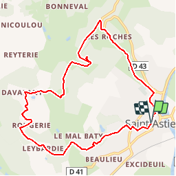
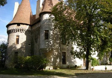
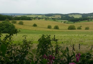
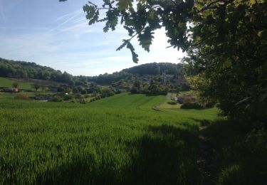
Randonnée Marche de 10,3 km à découvrir à Nouvelle-Aquitaine, Dordogne, Saint-Astier. Cette randonnée est proposée par YV24.

Description

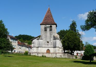
Selon PDIPR n°2 carte St Astier. Circuit bien tracé, vallonné, praticable en tout temps. Petite "Chapelle des Bois" à l'origine du nom de St Astier.

Profil altimétrique

Localisation

Pays :
France
Région :
Nouvelle-Aquitaine
Département/Province :
Dordogne
Commune :
Saint-Astier
Localité :
Unknown
Départ:(Dec)
Départ:(UTM)
305664 ; 5002053 (31T) N.

Randonnées à proximité

Randonnée Marche Saint-Astier - 24 Saint-Astier  - Photo
Marche
Patxito

Marche

Facile
(1)
Saint-Astier, Nouvelle-Aquitaine, Dordogne, France
11,4 km | 14,3 km-effort
2h 42min
Oui
Randonnée Marche Saint-Astier - GR654 ST ASTIER BERGERAC PINEL - Photo
Marche
kmedone

Marche

Difficile
(3)
Saint-Astier, Nouvelle-Aquitaine, Dordogne, France
122 km | 150 km-effort
31h 13min
Non
Randonnée A pied Saint-Aquilin - Boucle des Châteaux - Photo
A pied
PRO

A pied

Facile
Saint-Aquilin, Nouvelle-Aquitaine, Dordogne, France
11,3 km | 15,4 km-effort
3h 29min
Non
Randonnée Marche Saint-Aquilin - St Aquilin Chateaux 12km - Photo
Marche
YV24

Marche

Facile
(1)
Saint-Aquilin, Nouvelle-Aquitaine, Dordogne, France
11,9 km | 16,3 km-effort
3h 33min
Oui
Randonnée A pied Saint-Aquilin - Promenade de Charroux - Photo
A pied
PRO

A pied

Facile
Saint-Aquilin, Nouvelle-Aquitaine, Dordogne, France
4,2 km | 5,8 km-effort
1h 19min
Oui
Randonnée Marche Annesse-et-Beaulieu - Boucle de Gravelle - Photo
Marche
CC.RIDER

Marche

Difficile
Annesse-et-Beaulieu, Nouvelle-Aquitaine, Dordogne, France
13,1 km | 16,2 km-effort
3h 40min
Oui
Randonnée Marche Saint-Astier - Boucle de Saint Astier - Photo
Marche
CC.RIDER

Marche

Difficile
Saint-Astier, Nouvelle-Aquitaine, Dordogne, France
12,6 km | 16,3 km-effort
3h 42min
Oui
Randonnée Marche Léguillac-de-l'Auche - Leguillac 12km - Photo
Marche
amelie14

Marche

Moyen
Léguillac-de-l'Auche, Nouvelle-Aquitaine, Dordogne, France
12,1 km | 16,1 km-effort
2h 45min
Oui
Randonnée Marche Léguillac-de-l'Auche - 24 Léguillac de l'Auche - Photo
Marche
Patxito

Marche

Facile
Léguillac-de-l'Auche, Nouvelle-Aquitaine, Dordogne, France
13,8 km | 18 km-effort
3h 57min
Oui


Fermer
Mes abonnements