Randonnée V.T.T. Ardon - Wallis North 4 : Ardon - Gsteig - Photo

Wallis North 4 : Ardon - Gsteig

 ovronne
ovronne

Utilisateur

© OpenStreetMap contributors
Longueur
Longueur
33 km
Altitude max
Altitude max
2347 m
Dénivelé positif
Dénivelé positif
2316 m
Km-Effort
Km-Effort  
61 km
Altitude min
Altitude min
482 m
Dénivelé négatif
Dénivelé négatif
1620 m
Boucle
Boucle
Non
Date de création :
2014-12-10 00:00:00.0
Dernière modification :
2014-12-10 00:00:00.0

(0 Avis)

V.T.T.
V.T.T.
4h43
Difficulté : Inconnu

Scannez ce code QR pour ouvrir la randonnée dans l'application SityTrail

Application GPS de randonnée GRATUITE

Logo SityTrail SityTrail

IGN / Instituts géographiques

Télécharger SityTrail sur l'App Store Télécharger SityTrail sur Google Play

Logo SityTrail SityTrail World

Le monde est à vous

Télécharger SityTrail sur l'App Store Télécharger SityTrail sur Google Play Télécharger SityTrail sur Huawei AppGallery

À propos

Randonnée V.T.T. de 33 km à découvrir à Valais, Conthey, Ardon. Cette randonnée est proposée par ovronne.

Profil altimétrique

Localisation

Pays :
Suisse
Région :
Valais
Département/Province :
Conthey
Commune :
Ardon
Localité :
Unknown
Départ:(Dec)
Départ:(UTM)
365381 ; 5118941 (32T) N.

Randonnées à proximité

Randonnée Marche Nendaz - w10_03_nendaz - Photo
Marche
GUIDE+

Marche

Très facile
(1)
Nendaz, Valais, Conthey, Suisse
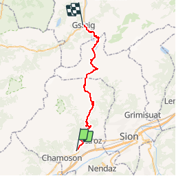
12,8 km | 18 km-effort
4h 8min
Oui
Randonnée A pied Ardon - Chemin des berges du Rhône - Photo
A pied
PRO

A pied

Facile
Ardon, Valais, Conthey, Suisse
4,4 km | 4,9 km-effort
1h 6min
Non
Randonnée Marche Sion - Tour du Massif des Muverans - Photo
Marche
illustre

Marche

Très facile
Sion, Valais, Sion, Suisse
6,2 km | 14,1 km-effort
22h 11min
Non
Randonnée Autre activité Conthey - st_bg_conthey - Photo
Autre activité
GUIDE+

Autre activité

Très facile
Conthey, Valais, Conthey, Suisse
22 km | 42 km-effort
9h 21min
Non
Randonnée V.T.T. Nendaz - Tour du MontFort - easy - Photo
V.T.T.
GUIDE+

V.T.T.

Très facile
Nendaz, Valais, Conthey, Suisse
48 km | 84 km-effort
Inconnu
Oui
Randonnée Marche Nendaz - Sentier des pives - Photo
Marche
verpoorten

Marche

Difficile
Nendaz, Valais, Conthey, Suisse
10 km | 16,7 km-effort
3h 48min
Oui
Randonnée Marche Chamoson - saint - Photo
Marche
André Luisier

Marche

Facile
Chamoson, Valais, Conthey, Suisse
36 km | 43 km-effort
6h 53min
Non
Randonnée Vélo Saillon - Martigny -Sion iii - Photo
Vélo
PurroB

Vélo

Très facile
Saillon, Valais, Martigny, Suisse
51 km | 58 km-effort
2h 21min
Oui
Randonnée Marche Ardon - Ardon, Einzon - Photo
Marche
rpf

Marche

Très facile
Ardon, Valais, Conthey, Suisse
8,1 km | 21 km-effort
6h 30min
Oui


Fermer
Mes abonnements