Randonnée Marche Orsières - Lacs de Fenêtre  - Photo
 verbier
verbier

Utilisateur

© OpenStreetMap contributors
Longueur
Longueur
10,2 km
Altitude max
Altitude max
2698 m
Dénivelé positif
Dénivelé positif
1139 m
Km-Effort
Km-Effort  
23 km
Altitude min
Altitude min
1702 m
Dénivelé négatif
Dénivelé négatif
365 m
Boucle
Boucle
Non
Date de création :
2014-12-10 00:00:00.0
Dernière modification :
2014-12-10 00:00:00.0

(0 Avis)

Marche
Marche
3h57
Difficulté : Inconnu

Scannez ce code QR pour ouvrir la randonnée dans l'application SityTrail

Application GPS de randonnée GRATUITE

Logo SityTrail SityTrail

IGN / Instituts géographiques

Télécharger SityTrail sur l'App Store Télécharger SityTrail sur Google Play

Logo SityTrail SityTrail World

Le monde est à vous

Télécharger SityTrail sur l'App Store Télécharger SityTrail sur Google Play Télécharger SityTrail sur Huawei AppGallery

À propos

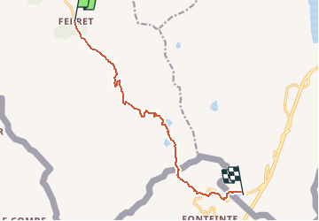
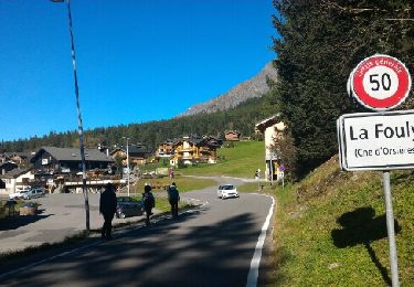
Randonnée Marche de 10,2 km à découvrir à Valais, Entremont, Orsières. Cette randonnée est proposée par verbier.
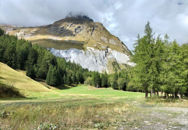
Description

From the high mountain pasture “Les Ars”, go on the path to the pasture of “Plan-La-Chaux”, then take the path to the left to the “Lacs Fenêtre”. The path goes on to the Col Fenêtre, at the frontier between Switzerland and Italy, then go back down for the Grand-St-Bernard pass road. The path follows that road to the arrival at the hospice.
Variant 1: From the “Lacs Fenêtre”, take the path to the left through the other side, to the “Col des Bastillons” and “Col des Chevaux” before to arrive at the Grand-St-Bernard pass.

Profil altimétrique

Points d'intérêt

Point d'intérêt Orsières - Lacs Fenêtre - Photo
verbier
ORSIÈRES 
Point d'intérêt Orsières - Col du Bastillon - Photo
verbier
ORSIÈRES 
Point d'intérêt Bourg-Saint-Pierre - Col du Grand-Saint-Bernard - Photo
verbier
BOURG-SAINT-PIERRE 
Point d'intérêt Orsières - Ferret - Photo
verbier
ORSIÈRES 

Localisation

Pays :
Suisse
Région :
Valais
Département/Province :
Entremont
Commune :
Orsières
Localité :
Unknown
Départ:(Dec)
Départ:(UTM)
353041 ; 5086464 (32T) N.

Randonnées à proximité

Randonnée A pied Orsières - Trail Verbier St-Bernard - Traversée - Photo
A pied
PRO

A pied

Très difficile
Orsières, Valais, Entremont, Suisse
37 km | 70 km-effort
15h 47min
Non
Randonnée A pied Orsières - Sentier des Bergers - Photo
A pied
PRO

A pied

Facile
Orsières, Valais, Entremont, Suisse
4,8 km | 9,2 km-effort
2h 5min
Non
Randonnée A pied Courmayeur - Itinerario 23 Rifugio Dalmazzi - Photo
A pied
PRO

A pied

Facile
Courmayeur, Vallée d'Aoste, Inconnu, Italie
4,1 km | 6,6 km-effort
1h 29min
Non
Randonnée Marche Courmayeur - TMB J4 Ref.ELENA - COURMAYEUR - Photo
Marche
GerardBouche

Marche

Moyen
Courmayeur, Vallée d'Aoste, Inconnu, Italie
13,5 km | 22 km-effort
4h 18min
Non
Randonnée Marche Courmayeur - TMB day 4 - Photo
Marche
elixpomatia

Marche

Moyen
Courmayeur, Vallée d'Aoste, Inconnu, Italie
16,6 km | 27 km-effort
5h 37min
Non
Randonnée Marche Orsières - La Fouly, Randonée hivernale, Sentier de l''Amône  - Photo
Marche
verbier

Marche

Très facile
(1)
Orsières, Valais, Entremont, Suisse
1,9 km | 2,7 km-effort
50min
Oui
Randonnée Marche Orsières - ferret La Foully - Photo
Marche
michauxpaul

Marche

Moyen
Orsières, Valais, Entremont, Suisse
4,6 km | 6,1 km-effort
2h 20min
Non
Randonnée Marche Orsières - fully  - Photo
Marche
suzanne.bron

Marche

Facile
Orsières, Valais, Entremont, Suisse
3,8 km | 4,9 km-effort
1h 19min
Non
Randonnée Marche Courmayeur - TMB6 AN - Photo
Marche
reneperrin

Marche

Facile
Courmayeur, Vallée d'Aoste, Inconnu, Italie
12,6 km | 21 km-effort
4h 5min
Non


Fermer
Mes abonnements