Randonnée Marche Orsières - Sentier des bouquetins - Photo

Sentier des bouquetins

 verbier
verbier

Utilisateur

© OpenStreetMap contributors
Longueur
Longueur
8,5 km
Altitude max
Altitude max
1997 m
Dénivelé positif
Dénivelé positif
243 m
Km-Effort
Km-Effort  
13 km
Altitude min
Altitude min
1601 m
Dénivelé négatif
Dénivelé négatif
626 m
Boucle
Boucle
Non
Date de création :
2014-12-10 00:00:00.0
Dernière modification :
2014-12-10 00:00:00.0

(0 Avis)

Marche
Marche
--
Difficulté : Inconnu

Scannez ce code QR pour ouvrir la randonnée dans l'application SityTrail

Application GPS de randonnée GRATUITE

Logo SityTrail SityTrail

IGN / Instituts géographiques

Télécharger SityTrail sur l'App Store Télécharger SityTrail sur Google Play

Logo SityTrail SityTrail World

Le monde est à vous

Télécharger SityTrail sur l'App Store Télécharger SityTrail sur Google Play Télécharger SityTrail sur Huawei AppGallery

À propos

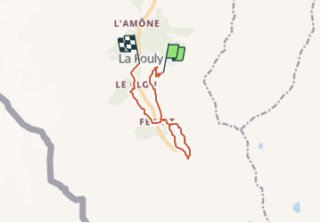
Randonnée Marche de 8,5 km à découvrir à Valais, Entremont, Orsières. Cette randonnée est proposée par verbier.

Description

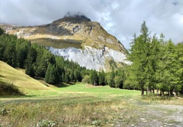
Eine schöne Wanderung mit vielen Informationen über das Leben

der Steinböcke. Start: La Fouly oder die Bergstation des Sesselliftes.

Sie passieren die Almen La Fouly und Mt-Percé, treffen auf den

« sentier des Bergers » bis les Ars dessous, retour via Ferret und

linke Uferseite der Dranse.

Profil altimétrique

Points d'intérêt

Point d'intérêt Orsières - Alpage de La Fouly - Photo
verbier
Point d'intérêt Orsières - Alpage de Mont Percé - Photo
verbier
Point d'intérêt Orsières - Alpage des Ars - Photo
verbier
ORSIÈRES 
Point d'intérêt Orsières - Sommet du télésiège - Photo
verbier
Point d'intérêt Orsières - La Fouly - Photo
verbier
ORSIÈRES 

Localisation

Pays :
Suisse
Région :
Valais
Département/Province :
Entremont
Commune :
Orsières
Localité :
Unknown
Départ:(Dec)
Départ:(UTM)
353284 ; 5087928 (32T) N.

Randonnées à proximité

Randonnée A pied Orsières - Trail Verbier St-Bernard - Traversée - Photo
A pied
PRO

A pied

Très difficile
Orsières, Valais, Entremont, Suisse
37 km | 70 km-effort
15h 47min
Non
Randonnée A pied Orsières - Sentier des Bergers - Photo
A pied
PRO

A pied

Facile
Orsières, Valais, Entremont, Suisse
4,8 km | 9,2 km-effort
2h 5min
Non
Randonnée Marche Courmayeur - TMB J4 Ref.ELENA - COURMAYEUR - Photo
Marche
GerardBouche

Marche

Moyen
Courmayeur, Vallée d'Aoste, Inconnu, Italie
13,5 km | 22 km-effort
4h 18min
Non
Randonnée Marche Orsières - La Fouly, Randonée hivernale, Sentier de l''Amône  - Photo
Marche
verbier

Marche

Très facile
(1)
Orsières, Valais, Entremont, Suisse
1,9 km | 2,7 km-effort
50min
Oui
Randonnée Marche Orsières - ferret La Foully - Photo
Marche
michauxpaul

Marche

Moyen
Orsières, Valais, Entremont, Suisse
4,6 km | 6,1 km-effort
2h 20min
Non
Randonnée Marche Orsières - fully  - Photo
Marche
suzanne.bron

Marche

Facile
Orsières, Valais, Entremont, Suisse
3,8 km | 4,9 km-effort
1h 19min
Non
Randonnée Marche Courmayeur - TMB6 AN - Photo
Marche
reneperrin

Marche

Facile
Courmayeur, Vallée d'Aoste, Inconnu, Italie
12,6 km | 21 km-effort
4h 5min
Non
Randonnée Marche Orsières - TMB J3 La FOULY - Ref. ELENA - Photo
Marche
GerardBouche

Marche

Difficile
Orsières, Valais, Entremont, Suisse
10,3 km | 23 km-effort
4h 46min
Non
Randonnée Marche Orsières - Cabane de l''A Neuve - Photo
Marche
verbier

Marche

Très facile
Orsières, Valais, Entremont, Suisse
5,4 km | 16,6 km-effort
2h 43min
Non


Fermer
Mes abonnements