Randonnée Marche Obernai - Obernai-150623 - VVF-Bischenberg - Photo

Obernai-150623 - VVF-Bischenberg

 randodan
randodan

Utilisateur

© OpenStreetMap contributors
Longueur
Longueur
10,3 km
Altitude max
Altitude max
362 m
Dénivelé positif
Dénivelé positif
254 m
Km-Effort
Km-Effort  
13,7 km
Altitude min
Altitude min
188 m
Dénivelé négatif
Dénivelé négatif
252 m
Boucle
Boucle
Oui
Date de création :
2015-06-26 00:00:00.0
Dernière modification :
2015-06-26 00:00:00.0

(1 Avis)

Marche
Marche
2h40
Difficulté : Facile

Scannez ce code QR pour ouvrir la randonnée dans l'application SityTrail

Application GPS de randonnée GRATUITE

Logo SityTrail SityTrail

IGN / Instituts géographiques

Télécharger SityTrail sur l'App Store Télécharger SityTrail sur Google Play

Logo SityTrail SityTrail World

Le monde est à vous

Télécharger SityTrail sur l'App Store Télécharger SityTrail sur Google Play Télécharger SityTrail sur Huawei AppGallery

À propos

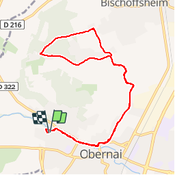
Randonnée Marche de 10,3 km à découvrir à Grand Est, Bas-Rhin, Obernai. Cette randonnée est proposée par randodan.

Description

Obernais, 23 juin 2015<br>
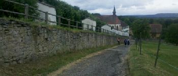
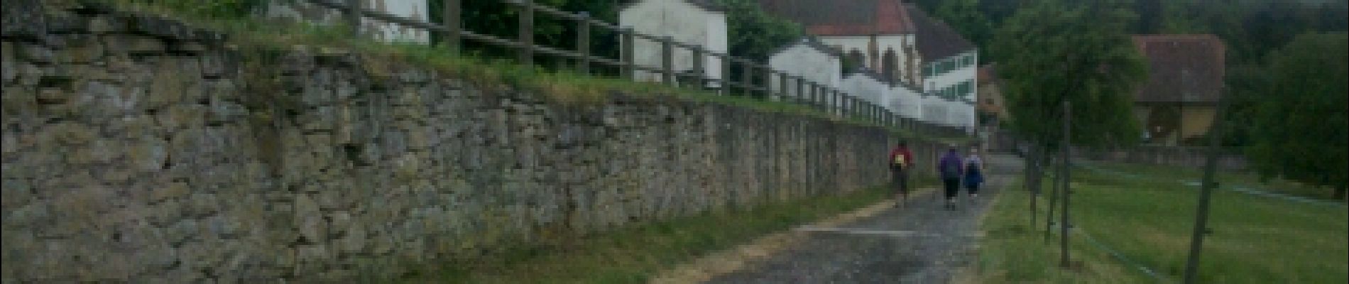
- Couvent du Bischenberg, Le Kilbs -<br>
(d'après la fiche VVF Rando.2)<br>
8h50, départ du VVF.<br>
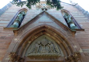
Personne ne veut l'escalier pour démarrer, alors, bitume-bitume . Au Couvent du Bischenberg, très beau Chemin de Croix.<br>
Une petite erreur d'interprétation de la description (fiche) à l'entrée dans Kilbs nous fait rater le chemin du Mont National, et à la place, c'est bitume-bitume :o(. Confusion aussi sur la fiche qui mélange l'escalier et le passage par la route du bas.<br>
Retour bitume-bitume ; 11h30 au VVF.<br>
5 participants (Jo,Ca,Ja,Chan,Da).

Profil altimétrique

Photos

Points d'intérêt

Point d'intérêt Bischoffsheim - 01 - Le Couvent du Bischenberg et son Chemin de Croix - Photo
randodan

Localisation

Pays :
France
Région :
Grand Est
Département/Province :
Bas-Rhin
Commune :
Obernai
Localité :
Unknown
Départ:(Dec)
Départ:(UTM)
386830 ; 5369235 (32U) N.

Commentaires

Veuillez vous connecter pour laisser un commentaire ou une note


intéressant


Randonnées à proximité

Randonnée Marche Ottrott - Le circuit sud du Mur Païen - Photo
Marche
VacheKiri67

Marche

Facile
(2)
Ottrott, Grand Est, Bas-Rhin, France
4,9 km | 6,3 km-effort
1h 56min
Non
Randonnée Marche Ottrott - Le Mont Sainte-Odile depuis Otrott - Photo
Marche
VacheKiri67

Marche

Moyen
(1)
Ottrott, Grand Est, Bas-Rhin, France
13 km | 20 km-effort
6h 18min
Oui
Randonnée Marche Ottrott - Mur Paien complet - Photo
Marche
markrei

Marche

Moyen
(1)
Ottrott, Grand Est, Bas-Rhin, France
12 km | 16,4 km-effort
5h 25min
Oui
Randonnée Marche Obernai - Obernai gare - Mont St Odile - Photo
Marche
tracegps

Marche

Difficile
(2)
Obernai, Grand Est, Bas-Rhin, France
20 km | 29 km-effort
5h 0min
Oui
Randonnée V.T.T. Ottrott - Sainte-Odile East-Face - Photo
V.T.T.
tracegps

V.T.T.

Difficile
(1)
Ottrott, Grand Est, Bas-Rhin, France
24 km | 39 km-effort
3h 0min
Oui
Randonnée A pied Rosheim - Circuit du Vignoble - Photo
A pied
PRO

A pied

Facile
Rosheim, Grand Est, Bas-Rhin, France
8,8 km | 11,7 km-effort
2h 38min
Oui
Randonnée A pied Bischoffsheim - Circuit des Balcons - Photo
A pied
PRO

A pied

Facile
(1)
Bischoffsheim, Grand Est, Bas-Rhin, France
12,4 km | 15,4 km-effort
3h 30min
Oui
Randonnée Marche Obernai - sentier des merveilles - Photo
Marche
semila

Marche

Difficile
(1)
Obernai, Grand Est, Bas-Rhin, France
11 km | 16,6 km-effort
4h 8min
Oui
Randonnée V.T.T. Rosheim - schnacker tour le grand 8 circuit magique - Photo
V.T.T.
raphnou

V.T.T.

Difficile
(1)
Rosheim, Grand Est, Bas-Rhin, France
29 km | 39 km-effort
2h 30min
Oui


Fermer
Mes abonnements