Randonnée Marche Pollestres - POLLESTRES 66 - rando a travers champs prairies et vignes - CANOHES - NYLS - Photo

POLLESTRES 66 - rando a travers champs prairies et vignes - CANOHES - NYLS

 jeff66
jeff66

Utilisateur

© OpenStreetMap contributors
Longueur
Longueur
10,4 km
Altitude max
Altitude max
101 m
Dénivelé positif
Dénivelé positif
98 m
Km-Effort
Km-Effort  
11,7 km
Altitude min
Altitude min
51 m
Dénivelé négatif
Dénivelé négatif
99 m
Boucle
Boucle
Oui
Date de création :
2015-07-20 00:00:00.0
Dernière modification :
2015-07-20 00:00:00.0

(0 Avis)

Marche
Marche
1h55
Difficulté : Moyen

Scannez ce code QR pour ouvrir la randonnée dans l'application SityTrail

Application GPS de randonnée GRATUITE

Logo SityTrail SityTrail

IGN / Instituts géographiques

Télécharger SityTrail sur l'App Store Télécharger SityTrail sur Google Play

Logo SityTrail SityTrail World

Le monde est à vous

Télécharger SityTrail sur l'App Store Télécharger SityTrail sur Google Play Télécharger SityTrail sur Huawei AppGallery

À propos

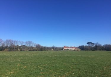
Randonnée Marche de 10,4 km à découvrir à Occitanie, Pyrénées-Orientales, Pollestres. Cette randonnée est proposée par jeff66.

Description

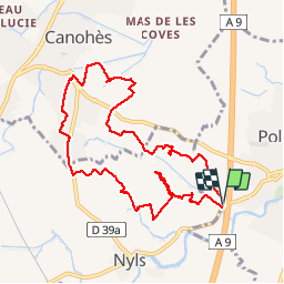
POLLESTRES 66 - Parking le long de la D23a après le pont sur A9 - relais télécom - centre équestre - Estany de Nyls - ferme d'élevage avicole - CANOHES - les clotes - traversée D39 - Agulla Del Rentador - D39 - hcxcontourner le cimetière - chemin de la Ribe petite - quartier résidentiel - Caraig - prendre D39a direction Nyls - la Soleilade - circuit pédestre du mas Bécha - Nyls - correc de Negabous - cimetière - centre équestre - retour par D23a

Profil altimétrique

Photos

Localisation

Pays :
France
Région :
Occitanie
Département/Province :
Pyrénées-Orientales
Commune :
Pollestres
Localité :
Unknown
Départ:(Dec)
Départ:(UTM)
488498 ; 4720205 (31T) N.

Randonnées à proximité

Randonnée Marche Montescot - 66 VILLENEUVE-DE-LA-RAHO grand tour du lac en Sens horaire  - Photo
Marche
jeff66

Marche

Facile
(1)
Montescot, Occitanie, Pyrénées-Orientales, France
6,7 km | 7,5 km-effort
1h 4min
Oui
Randonnée Marche Villeneuve-de-la-Raho - 66 VILLENEUVE-DE-LA-RAHO - grand tour périphérique du lac par les lignes de crêtes  - Photo
Marche
jeff66

Marche

Facile
(2)
Villeneuve-de-la-Raho, Occitanie, Pyrénées-Orientales, France
10 km | 11,5 km-effort
1h 44min
Oui
Randonnée V.T.T. Canohès - canohes - Photo
V.T.T.
haroldtheviking

V.T.T.

Moyen
(2)
Canohès, Occitanie, Pyrénées-Orientales, France
37 km | 44 km-effort
2h 12min
Oui
Randonnée Marche Perpignan - Perpignan  - Photo
Marche
ombrabella

Marche

Très facile
Perpignan, Occitanie, Pyrénées-Orientales, France
18 km | 19,9 km-effort
2h 23min
Non
Randonnée Marche Perpignan - canal Perpignan  - Photo
Marche
Fildesir

Marche

Très facile
Perpignan, Occitanie, Pyrénées-Orientales, France
25 km | 27 km-effort
7h 29min
Non
Randonnée Marche Montescot - 66 VILLENEUVE-DE-LA-RAHO grand tour du lac en Sens horaire  - Photo
Marche
jeff66

Marche

Facile
Montescot, Occitanie, Pyrénées-Orientales, France
6,7 km | 7,5 km-effort
1h 4min
Oui
Randonnée Marche Perpignan - 66 PERPIGNAN - mas Balande, parc des sports, aviateurs, St Martin, MAV, Vertefeuille - Photo
Marche
jeff66

Marche

Facile
Perpignan, Occitanie, Pyrénées-Orientales, France
10,6 km | 11,6 km-effort
1h 52min
Oui
Randonnée Marche Perpignan - Xxx - Photo
Marche
jeff66

Marche

Moyen
Perpignan, Occitanie, Pyrénées-Orientales, France
15,1 km | 16,9 km-effort
2h 26min
Oui
Randonnée Marche Perpignan - 66 PERPIGNAN - autour des mas Du petit et du grand Bresson - Photo
Marche
jeff66

Marche

Facile
Perpignan, Occitanie, Pyrénées-Orientales, France
4,3 km | 4,9 km-effort
52min
Oui


Fermer
Mes abonnements