Randonnée V.T.T. Chiny - B.Izel12A60km908mVTC - Photo

B.Izel12A60km908mVTC

 francois58
francois58

Utilisateur

© OpenStreetMap contributors
Longueur
Longueur
60 km
Altitude max
Altitude max
441 m
Dénivelé positif
Dénivelé positif
1101 m
Km-Effort
Km-Effort  
75 km
Altitude min
Altitude min
264 m
Dénivelé négatif
Dénivelé négatif
1099 m
Boucle
Boucle
Oui
Date de création :
2017-06-19 00:00:00.0
Dernière modification :
2017-06-19 00:00:00.0

(1 Avis)

V.T.T.
V.T.T.
4h49
Difficulté : Moyen

Scannez ce code QR pour ouvrir la randonnée dans l'application SityTrail

Application GPS de randonnée GRATUITE

Logo SityTrail SityTrail

IGN / Instituts géographiques

Télécharger SityTrail sur l'App Store Télécharger SityTrail sur Google Play

Logo SityTrail SityTrail World

Le monde est à vous

Télécharger SityTrail sur l'App Store Télécharger SityTrail sur Google Play Télécharger SityTrail sur Huawei AppGallery

À propos

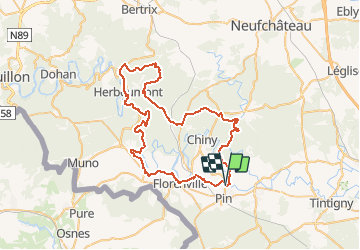
Randonnée V.T.T. de 60 km à découvrir à Wallonie, Luxembourg, Chiny. Cette randonnée est proposée par francois58.

Description

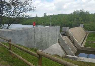
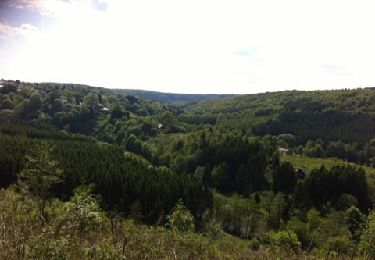
Très belle randonnée : 1/5 campagne, 4/5 forêt - 1/4 macadam - 3/4 empierré.
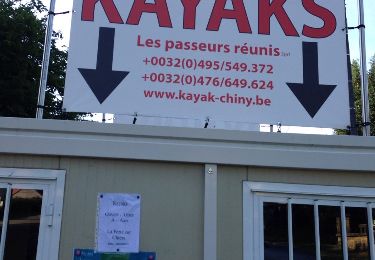
Pause repas possible à la Taverne du Randonneur (Herbeumont) - très sympa !
ATTENTION : prévoir un éclairage pour un passage de qqs centaines de mètres dans un tunnel (trous !).

Profil altimétrique

Points d'intérêt

Point d'intérêt Herbeumont - Taverne Le Randonneur - Photo
francois58
Point d'intérêt Herbeumont - Attention tunnel - Photo
francois58
HERBEUMONT 

Localisation

Pays :
Belgique
Région :
Wallonie
Département/Province :
Luxembourg
Commune :
Chiny
Localité :
Izel
Départ:(Dec)
Départ:(UTM)
671087 ; 5507755 (31U) N.

Commentaires

Veuillez vous connecter pour laisser un commentaire ou une note


Bonjour, Cet itinéraire comporte un tronçon de 500 mètres (Tunnel de Linglé 150 m côté Bertrix 50 m côté Herbeumont) qu'il est INTERDIT de traverser sous peine de poursuites. Veuillez retirer immédiatement cet itinéraire du site. Les propriétaires.


Randonnées à proximité

Randonnée Marche Florenville - RB-Lu-19_Chameleux_via-racc-2 - Photo
Marche
PRO

Marche

Très facile
(2)
Florenville, Wallonie, Luxembourg, Belgique
18 km | 22 km-effort
4h 43min
Oui
Randonnée Marche Florenville - RB-Lu-14_Lacuisine - Photo
Marche
PRO

Marche

Moyen
(3)
Florenville, Wallonie, Luxembourg, Belgique
24 km | 31 km-effort
6h 8min
Oui
Randonnée Marche Chiny - Semois, rochers et étangs - Photo
Marche
Vagabond gaumardennais

Marche

Difficile
(2)
Chiny, Wallonie, Luxembourg, Belgique
14,8 km | 19,4 km-effort
2h 41min
Oui
Randonnée Marche Chiny - Le long de la semois et sur les crêtes de Chiny - Photo
Marche
antoinebaetsle

Marche

Très facile
(1)
Chiny, Wallonie, Luxembourg, Belgique
6,7 km | 8,3 km-effort
1h 53min
Oui
Randonnée Marche Chiny - Autour de la forêt de Chiny - Photo
Marche
Dom62

Marche

Facile
(1)
Chiny, Wallonie, Luxembourg, Belgique
12 km | 15,3 km-effort
2h 37min
Oui
Randonnée Marche Chiny - wandeling chiny - Photo
Marche
luc.delouw

Marche

Très facile
(2)
Chiny, Wallonie, Luxembourg, Belgique
7,4 km | 9,5 km-effort
1h 41min
Oui
Randonnée Marche Florenville - RB-Lu-19_Chameleux_via-racc-1 - Photo
Marche
PRO

Marche

Très facile
(1)
Florenville, Wallonie, Luxembourg, Belgique
12,6 km | 16,3 km-effort
3h 32min
Oui
Randonnée Marche Chiny - RF-Lu-13 - Entre Semois et Vierre : Chiny - Photo
Marche
PRO

Marche

Très facile
(2)
Chiny, Wallonie, Luxembourg, Belgique
10,9 km | 14,1 km-effort
3h 4min
Oui
Randonnée A pied Chiny - 36. Le Charmois - Photo
A pied
PRO

A pied

Facile
Chiny, Wallonie, Luxembourg, Belgique
13,7 km | 16,3 km-effort
3h 42min
Oui


Fermer
Mes abonnements