Randonnée Marche Hoeilaert - Soignes-Hulpe South - Photo
 cgrbxl
cgrbxl

Utilisateur

© OpenStreetMap contributors
Longueur
Longueur
13,9 km
Altitude max
Altitude max
146 m
Dénivelé positif
Dénivelé positif
225 m
Km-Effort
Km-Effort  
16,9 km
Altitude min
Altitude min
67 m
Dénivelé négatif
Dénivelé négatif
226 m
Boucle
Boucle
Oui
Date de création :
2016-07-02 00:00:00.0
Dernière modification :
2016-07-02 00:00:00.0

(3 Avis)

Marche
Marche
3h46
Difficulté : Facile

Scannez ce code QR pour ouvrir la randonnée dans l'application SityTrail

Application GPS de randonnée GRATUITE

Logo SityTrail SityTrail

IGN / Instituts géographiques

Télécharger SityTrail sur l'App Store Télécharger SityTrail sur Google Play

Logo SityTrail SityTrail World

Le monde est à vous

Télécharger SityTrail sur l'App Store Télécharger SityTrail sur Google Play Télécharger SityTrail sur Huawei AppGallery

À propos

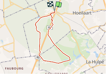
Randonnée Marche de 13,9 km à découvrir à Flandre, Brabant flamand, Hoeilaert. Cette randonnée est proposée par cgrbxl.

Description

14 Km nice walk with the beautiful Hulpe chateau mid way.

Profil altimétrique

Photos

Localisation

Pays :
Belgique
Région :
Flandre
Département/Province :
Brabant flamand
Commune :
Hoeilaert
Localité :
Hoeilaart
Départ:(Dec)
Départ:(UTM)
601701 ; 5625112 (31U) N.

Commentaires

Veuillez vous connecter pour laisser un commentaire ou une note


Très belle marche


Belle promenade. Super facile à suivre avec toutes les photos


Agréable promenade


Randonnées à proximité

Randonnée Marche Hoeilaert - RL-GG-04_Hoielart_Genval - Photo
Marche
PRO

Marche

Très difficile
(5)
Hoeilaert, Flandre, Brabant flamand, Belgique
23 km | 28 km-effort
5h 54min
Non
Randonnée Marche Auderghem - RB-Br-09 Rac02 - Photo
Marche
PRO

Marche

Facile
(9)
Auderghem, Bruxelles-Capitale, Inconnu, Belgique
15,3 km | 18 km-effort
4h 5min
Oui
Randonnée Marche Auderghem - RB-Br-09 - Photo
Marche
PRO

Marche

Moyen
(6)
Auderghem, Bruxelles-Capitale, Inconnu, Belgique
20 km | 25 km-effort
5h 34min
Oui
Randonnée Marche La Hulpe - RB-Bw-12_La-Hulpe_via-racc-1-et-2 - Photo
Marche
PRO

Marche

Difficile
(15)
La Hulpe, Wallonie, Brabant wallon, Belgique
14,3 km | 17,7 km-effort
4h 1min
Oui
Randonnée V.T.T. Uccle - O2bikers_33_foret_de_Soignes - Photo
V.T.T.
GUIDE+

V.T.T.

Très facile
(8)
Uccle, Bruxelles-Capitale, Inconnu, Belgique
25 km | 30 km-effort
3h 18min
Oui
Randonnée V.T.T. Rhode-Saint-Genèse - VTT des etangs - Photo
V.T.T.
GUIDE
pascalou73

V.T.T.

Moyen
(1)
Rhode-Saint-Genèse, Flandre, Brabant flamand, Belgique
31 km | 37 km-effort
2h 24min
Non
Randonnée Marche La Hulpe - La Hulpe - Circuit Natura 2000, des sites qui valent le détour - Bw02 - Photo
Marche
GUIDE+

Marche

Moyen
(5)
La Hulpe, Wallonie, Brabant wallon, Belgique
4,7 km | 5,9 km-effort
1h 16min
Non
Randonnée V.T.T. Rhode-Saint-Genèse - vtt de la forêt de Soigne - Photo
V.T.T.
GUIDE
pascalou73

V.T.T.

Facile
(1)
Rhode-Saint-Genèse, Flandre, Brabant flamand, Belgique
31 km | 38 km-effort
2h 27min
Oui
Randonnée Marche Rhode-Saint-Genèse - De Rhode Saint-Genèse à Groenendaal parl la forêt de Soignes - Photo
Marche
GUIDE
Desrumaux

Marche

Facile
(4)
Rhode-Saint-Genèse, Flandre, Brabant flamand, Belgique
10,3 km | 11,9 km-effort
2h 36min
Oui


Fermer
Mes abonnements