Randonnée Marche Précy-sur-Vrin - Précis projet - Photo
 Pleh
Pleh

Utilisateur

© OpenStreetMap contributors
Longueur
Longueur
8,3 km
Altitude max
Altitude max
177 m
Dénivelé positif
Dénivelé positif
132 m
Km-Effort
Km-Effort  
10,1 km
Altitude min
Altitude min
105 m
Dénivelé négatif
Dénivelé négatif
130 m
Boucle
Boucle
Oui
Date de création :
2019-04-28 13:59:36.302
Dernière modification :
2019-04-28 13:59:36.327

(0 Avis)

Marche
Marche
2h10
Difficulté : Facile

Scannez ce code QR pour ouvrir la randonnée dans l'application SityTrail

Application GPS de randonnée GRATUITE

Logo SityTrail SityTrail

IGN / Instituts géographiques

Télécharger SityTrail sur l'App Store Télécharger SityTrail sur Google Play

Logo SityTrail SityTrail World

Le monde est à vous

Télécharger SityTrail sur l'App Store Télécharger SityTrail sur Google Play Télécharger SityTrail sur Huawei AppGallery

À propos

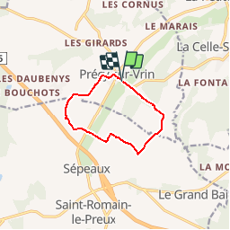
Randonnée Marche de 8,3 km à découvrir à Bourgogne-Franche-Comté, Yonne, Précy-sur-Vrin. Cette randonnée est proposée par Pleh.

Profil altimétrique

Localisation

Pays :
France
Région :
Bourgogne-Franche-Comté
Département/Province :
Yonne
Commune :
Précy-sur-Vrin
Localité :
Unknown
Départ:(Dec)
Départ:(UTM)
518637 ; 5312550 (31T) N.

Randonnées à proximité

Randonnée Marche Cézy - Thèmes 9 Km - Photo
Marche
mesnyjy

Marche

Moyen
(1)
Cézy, Bourgogne-Franche-Comté, Yonne, France
9,1 km | 11,6 km-effort
2h 29min
Oui
Randonnée Marche La Celle-Saint-Cyr - Les foulons-Le moulin d'en bas  - Photo
Marche
papyjv8991

Marche

Facile
La Celle-Saint-Cyr, Bourgogne-Franche-Comté, Yonne, France
5,2 km | 6,4 km-effort
1h 41min
Oui
Randonnée Marche Précy-sur-Vrin - Rando Jovinien Précy sur Vrin (8,3 km) - Photo
Marche
Pleh

Marche

Facile
Précy-sur-Vrin, Bourgogne-Franche-Comté, Yonne, France
8,3 km | 9,8 km-effort
2h 8min
Oui
Randonnée Marche Précy-sur-Vrin - Précy sur Vrin 8,3 km - Photo
Marche
Pleh

Marche

Facile
Précy-sur-Vrin, Bourgogne-Franche-Comté, Yonne, France
8,3 km | 9,9 km-effort
2h 9min
Oui
Randonnée Cheval La Celle-Saint-Cyr - Géro.Etape3 - Photo
Cheval
aucamus

Cheval

Très facile
La Celle-Saint-Cyr, Bourgogne-Franche-Comté, Yonne, France
24 km | 27 km-effort
3h 28min
Non
Randonnée Marche La Celle-Saint-Cyr - La Petite Celle - Le Vrin - point de vue à Thèmes - Photo
Marche
py.bretecher

Marche

Facile
(2)
La Celle-Saint-Cyr, Bourgogne-Franche-Comté, Yonne, France
5,5 km | 6,8 km-effort
Inconnu
Oui
Randonnée Randonnée à dos d'âne La Celle-Saint-Cyr - Geronimo.2023.Compostelle.5. - Photo
Randonnée à dos d'âne
aucamus

Randonnée à dos d'âne

Très facile
La Celle-Saint-Cyr, Bourgogne-Franche-Comté, Yonne, France
19 km | 24 km-effort
Inconnu
Non
Randonnée A pied La Celle-Saint-Cyr - La Celle - Peteloup - Thèmes - La Celle - Photo
A pied
Papymimi

A pied

Facile
(1)
La Celle-Saint-Cyr, Bourgogne-Franche-Comté, Yonne, France
11 km | 13,2 km-effort
3h 0min
Oui
Randonnée A pied La Celle-Saint-Cyr - La Celle St Cyr/Chartreuse 13 km - Photo
A pied
Pleh

A pied

Facile
La Celle-Saint-Cyr, Bourgogne-Franche-Comté, Yonne, France
12,5 km | 15 km-effort
Inconnu
Oui


Fermer
Mes abonnements