Randonnée Marche Saint-Christophe-en-Oisans - RETOUR du REFUGE DU SOREILLER-09-09-2016 - Photo

RETOUR du REFUGE DU SOREILLER-09-09-2016

 RD78-38
RD78-38

Utilisateur

© OpenStreetMap contributors
Longueur
Longueur
5,6 km
Altitude max
Altitude max
2706 m
Dénivelé positif
Dénivelé positif
30 m
Km-Effort
Km-Effort  
9,6 km
Altitude min
Altitude min
1602 m
Dénivelé négatif
Dénivelé négatif
1123 m
Boucle
Boucle
Non
Date de création :
2016-09-12 00:00:00.0
Dernière modification :
2020-07-11 00:22:28.819

(0 Avis)

Marche
Marche
3h02
Difficulté : Moyen

Scannez ce code QR pour ouvrir la randonnée dans l'application SityTrail

Application GPS de randonnée GRATUITE

Logo SityTrail SityTrail

IGN / Instituts géographiques

Télécharger SityTrail sur l'App Store Télécharger SityTrail sur Google Play

Logo SityTrail SityTrail World

Le monde est à vous

Télécharger SityTrail sur l'App Store Télécharger SityTrail sur Google Play Télécharger SityTrail sur Huawei AppGallery

À propos

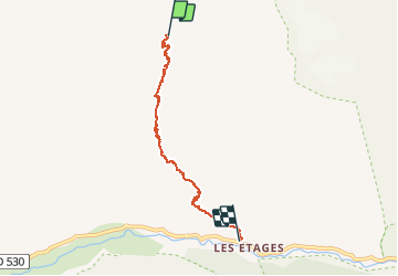
Randonnée Marche de 5,6 km à découvrir à Auvergne-Rhône-Alpes, Isère, Saint-Christophe-en-Oisans. Cette randonnée est proposée par RD78-38.

Description

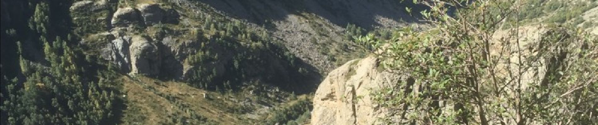
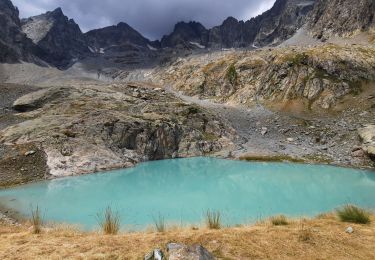
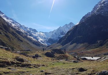
Descente sans aucune difficulté aux milieux de paysages exceptionnels avec des éclairages différents de la montée qui s'effectue par le même trajet.

Profil altimétrique

Photos

22 photos au total. Cliquez sur une photo pour les afficher toutes dans la galerie.

Localisation

Pays :
France
Région :
Auvergne-Rhône-Alpes
Département/Province :
Isère
Commune :
Saint-Christophe-en-Oisans
Localité :
Unknown
Départ:(Dec)
Départ:(UTM)
282629 ; 4982241 (32T) N.

Randonnées à proximité

Randonnée Marche Saint-Christophe-en-Oisans - Lac des Bèches - Photo
Marche
GuyVachet

Marche

Très difficile
Saint-Christophe-en-Oisans, Auvergne-Rhône-Alpes, Isère, France
16 km | 31 km-effort
6h 33min
Oui
Randonnée Marche Saint-Christophe-en-Oisans - Le Refuge de La Lavey - Photo
Marche
patjobou

Marche

Moyen
Saint-Christophe-en-Oisans, Auvergne-Rhône-Alpes, Isère, France
12,2 km | 20 km-effort
5h 52min
Oui
Randonnée Marche Saint-Christophe-en-Oisans - Malraux Refuge du Chateleret - Photo
Marche
rapako

Marche

Facile
Saint-Christophe-en-Oisans, Auvergne-Rhône-Alpes, Isère, France
12,1 km | 19,4 km-effort
5h 26min
Oui
Randonnée Marche Saint-Christophe-en-Oisans - Saint-Christophe-en-Oisans - Vallon des Etages - 6.5km 375m 3h20 - 2018 06 19 - Photo
Marche
Orcal37

Marche

Moyen
Saint-Christophe-en-Oisans, Auvergne-Rhône-Alpes, Isère, France
6,3 km | 11,2 km-effort
3h 20min
Oui
Randonnée Marche Saint-Christophe-en-Oisans - Saint-Christophe-en-Oisans - La Bérarde Cotillat (le Châtelleret) - 10.7km 390m 5h30 (45mn) - 2018 06 22 - Photo
Marche
Orcal37

Marche

Moyen
Saint-Christophe-en-Oisans, Auvergne-Rhône-Alpes, Isère, France
10,8 km | 16 km-effort
5h 30min
Oui
Randonnée Marche Saint-Christophe-en-Oisans - REFUGE DE CHATELLERET depuis LA BERARDE-07-09-2016 - Photo
Marche
RD78-38

Marche

Facile
Saint-Christophe-en-Oisans, Auvergne-Rhône-Alpes, Isère, France
14,9 km | 25 km-effort
6h 30min
Oui
Randonnée Marche Saint-Christophe-en-Oisans - MONTÉE vers LE REFUGE DU SOREILLER-08-09-2016 - Photo
Marche
RD78-38

Marche

Moyen
Saint-Christophe-en-Oisans, Auvergne-Rhône-Alpes, Isère, France
5,6 km | 16,9 km-effort
4h 5min
Non
Randonnée Marche Saint-Christophe-en-Oisans - Saint-Christophe-en-Oisans - Vallée du Vénéon les Etages - 5.2km 170m 3h15 - 2015 06 25 - Photo
Marche
Orcal37

Marche

Facile
Saint-Christophe-en-Oisans, Auvergne-Rhône-Alpes, Isère, France
5,2 km | 7,6 km-effort
3h 15min
Oui
Randonnée Marche Saint-Christophe-en-Oisans - Saint-Christophe-en-Oisans - de Champhorent au Refuge de La Lavey - 12.9km 570m 5h40 (1h00) - 2015 06 24 - Photo
Marche
Orcal37

Marche

Difficile
Saint-Christophe-en-Oisans, Auvergne-Rhône-Alpes, Isère, France
12,9 km | 21 km-effort
5h 40min
Oui


Fermer
Mes abonnements