Randonnée V.T.T. Lacrouzette - Lacrouzette VTT 2016 - Photo

Lacrouzette VTT 2016

 J-Mi
J-Mi

Utilisateur

© OpenStreetMap contributors
Longueur
Longueur
32 km
Altitude max
Altitude max
685 m
Dénivelé positif
Dénivelé positif
682 m
Km-Effort
Km-Effort  
41 km
Altitude min
Altitude min
485 m
Dénivelé négatif
Dénivelé négatif
665 m
Boucle
Boucle
Oui
Date de création :
2016-11-12 00:00:00.0
Dernière modification :
2016-11-12 00:00:00.0

(3 Avis)

V.T.T.
V.T.T.
2h36
Difficulté : Facile

Scannez ce code QR pour ouvrir la randonnée dans l'application SityTrail

Application GPS de randonnée GRATUITE

Logo SityTrail SityTrail

IGN / Instituts géographiques

Télécharger SityTrail sur l'App Store Télécharger SityTrail sur Google Play

Logo SityTrail SityTrail World

Le monde est à vous

Télécharger SityTrail sur l'App Store Télécharger SityTrail sur Google Play Télécharger SityTrail sur Huawei AppGallery

À propos

Randonnée V.T.T. de 32 km à découvrir à Occitanie, Tarn, Lacrouzette. Cette randonnée est proposée par J-Mi.

Description

30 KM de pur bonheur dans le Sidobre avec 600 de D

Profil altimétrique

Localisation

Pays :
France
Région :
Occitanie
Département/Province :
Tarn
Commune :
Lacrouzette
Localité :
Unknown
Départ:(Dec)
Départ:(UTM)
447288 ; 4834310 (31T) N.

Commentaires

Veuillez vous connecter pour laisser un commentaire ou une note


magnifique tour,tous les paysages et tous les chemins merci on s est régalé


Circuit tres bien , technique , ludique de beaux paysages dans cette belle montagne noire


Très beau circuit


Randonnées à proximité

Randonnée Marche Lacrouzette - les rochers de sidobre  - Photo
Marche
leroj73

Marche

Très facile
(1)
Lacrouzette, Occitanie, Tarn, France
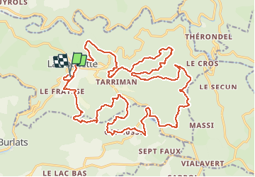
11,9 km | 15,5 km-effort
3h 31min
Oui
Randonnée Marche Lacrouzette - Sidobre  rocs de crémaussel et Lac du Merle 16 kms - Photo
Marche
cappelle

Marche

Très difficile
(1)
Lacrouzette, Occitanie, Tarn, France
15,6 km | 21 km-effort
4h 39min
Oui
Randonnée A pied Lacrouzette - les rochers du sidobre - Photo
A pied
leroj73

A pied

Très facile
(1)
Lacrouzette, Occitanie, Tarn, France
11,2 km | 15,2 km-effort
Inconnu
Oui
Randonnée V.T.T. Lacrouzette - Ronde des rochers 2008 - Photo
V.T.T.
tracegps

V.T.T.

Moyen
(1)
Lacrouzette, Occitanie, Tarn, France
30 km | 39 km-effort
2h 15min
Oui
Randonnée A pied Burlats - Chemin des Fontaines - Photo
A pied
PRO

A pied

Facile
Burlats, Occitanie, Tarn, France
7,3 km | 8,5 km-effort
1h 55min
Non
Randonnée Marche Burlats - Burlats cascade de la truite - Photo
Marche
poisson1103

Marche

Moyen
Burlats, Occitanie, Tarn, France
19,3 km | 30 km-effort
5h 22min
Non
Randonnée Marche Burlats - billets l'Agout 18kms 577m 4h30 - Photo
Marche
guiller

Marche

Facile
Burlats, Occitanie, Tarn, France
18,2 km | 25 km-effort
4h 44min
Oui
Randonnée Marche Lacrouzette - Sidobre - Photo
Marche
pantin

Marche

Moyen
Lacrouzette, Occitanie, Tarn, France
14,7 km | 19,1 km-effort
4h 21min
Oui
Randonnée Marche Burlats - Sidobre Castres  - Photo
Marche
GUIDE
Ada11

Marche

Facile
Burlats, Occitanie, Tarn, France
18,8 km | 26 km-effort
4h 28min
Oui


Fermer
Mes abonnements