Randonnée Marche Sermiers - sermiers  - Photo
 MarieDeBacker
MarieDeBacker

Utilisateur

© OpenStreetMap contributors
Longueur
Longueur
9,9 km
Altitude max
Altitude max
277 m
Dénivelé positif
Dénivelé positif
220 m
Km-Effort
Km-Effort  
12,8 km
Altitude min
Altitude min
133 m
Dénivelé négatif
Dénivelé négatif
219 m
Boucle
Boucle
Oui
Date de création :
2019-07-14 17:45:29.519
Dernière modification :
2019-07-14 17:45:29.576

(0 Avis)

Marche
Marche
2h45
Difficulté : Moyen

Scannez ce code QR pour ouvrir la randonnée dans l'application SityTrail

Application GPS de randonnée GRATUITE

Logo SityTrail SityTrail

IGN / Instituts géographiques

Télécharger SityTrail sur l'App Store Télécharger SityTrail sur Google Play

Logo SityTrail SityTrail World

Le monde est à vous

Télécharger SityTrail sur l'App Store Télécharger SityTrail sur Google Play Télécharger SityTrail sur Huawei AppGallery

À propos

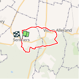
Randonnée Marche de 9,9 km à découvrir à Grand Est, Marne, Sermiers. Cette randonnée est proposée par MarieDeBacker.

Description

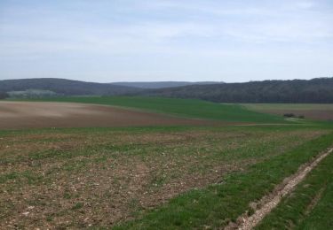
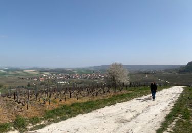
Jolie rando entre foret et vigne, empruntant l'ancien tracé du GR dans la foret.

Profil altimétrique

Localisation

Pays :
France
Région :
Grand Est
Département/Province :
Marne
Commune :
Sermiers
Localité :
Unknown
Départ:(Dec)
Départ:(UTM)
571782 ; 5445520 (31U) N.

Commentaires

Veuillez vous connecter pour laisser un commentaire ou une note


Randonnées à proximité

Randonnée Marche Sermiers - Sermier La Noelle 8,1 kms environ - Photo
Marche
quatre sans cinq

Marche

Moyen
(1)
Sermiers, Grand Est, Marne, France
8,1 km | 9,4 km-effort
2h 7min
Oui
Randonnée Marche Sermiers - SityTrail - parking route d'épernay-version hiver - Photo
Marche
quatre sans cinq

Marche

Moyen
(1)
Sermiers, Grand Est, Marne, France
8,8 km | 9,9 km-effort
1h 35min
Oui
Randonnée V.T.T. Villers-Allerand - La Montagne de Reims - Au SE de Villers-Allerand - Photo
V.T.T.
tracegps

V.T.T.

Difficile
Villers-Allerand, Grand Est, Marne, France
30 km | 38 km-effort
3h 0min
Oui
Randonnée V.T.T. Courtagnon - La Montagne de Reims- De Courtagnon à Germaine - Photo
V.T.T.
tracegps

V.T.T.

Difficile
Courtagnon, Grand Est, Marne, France
26 km | 31 km-effort
2h 15min
Oui
Randonnée Marche Écueil - Ecueil - Chamery 01 11 2012 - Photo
Marche
mousetik

Marche

Facile
Écueil, Grand Est, Marne, France
5,4 km | 7,1 km-effort
Inconnu
Oui
Randonnée Marche Ville-Dommange - 2012-04-01 Ville-Dommange - Ecueil - Photo
Marche
mousetik

Marche

Facile
(1)
Ville-Dommange, Grand Est, Marne, France
8,6 km | 11,2 km-effort
2h 0min
Oui
Randonnée Marche Courtagnon - Coutagnon - Photo
Marche
jybe

Marche

Courtagnon, Grand Est, Marne, France
21 km | 26 km-effort
4h 42min
Non
Randonnée Marche Courtagnon - COURTAGNON 19/10/2014 - Photo
Marche
remi.servel

Marche

Facile
(2)
Courtagnon, Grand Est, Marne, France
9,5 km | 11,4 km-effort
2h 29min
Oui
Randonnée Marche Ville-Dommange - petite balade - Photo
Marche
mousetik

Marche

Très facile
Ville-Dommange, Grand Est, Marne, France
3,5 km | 4 km-effort
1h 9min
Oui


Fermer
Mes abonnements