Randonnée Marche Saint-Jean-de-Bournay - Chapelle St Hugon - Photo
 yvos38
yvos38

Utilisateur

© OpenStreetMap contributors
Longueur
Longueur
3,8 km
Altitude max
Altitude max
522 m
Dénivelé positif
Dénivelé positif
77 m
Km-Effort
Km-Effort  
4,8 km
Altitude min
Altitude min
469 m
Dénivelé négatif
Dénivelé négatif
77 m
Boucle
Boucle
Oui
Date de création :
2016-12-15 00:00:00.0
Dernière modification :
2016-12-15 00:00:00.0

(0 Avis)

Marche
Marche
1h02
Difficulté : Très facile

Scannez ce code QR pour ouvrir la randonnée dans l'application SityTrail

Application GPS de randonnée GRATUITE

Logo SityTrail SityTrail

IGN / Instituts géographiques

Télécharger SityTrail sur l'App Store Télécharger SityTrail sur Google Play

Logo SityTrail SityTrail World

Le monde est à vous

Télécharger SityTrail sur l'App Store Télécharger SityTrail sur Google Play Télécharger SityTrail sur Huawei AppGallery

À propos

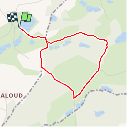
Randonnée Marche de 3,8 km à découvrir à Auvergne-Rhône-Alpes, Isère, Saint-Jean-de-Bournay. Cette randonnée est proposée par yvos38.

Description

Petite promenade sympathique avec passage devant la chapelle St Hugon reconstruite dans les années soixante (chacun appréciera son architecture), puis passage devant le chêne St Hugon muticentenaire.

Profil altimétrique

Localisation

Pays :
France
Région :
Auvergne-Rhône-Alpes
Département/Province :
Isère
Commune :
Saint-Jean-de-Bournay
Localité :
Unknown
Départ:(Dec)
Départ:(UTM)
669234 ; 5038137 (31T) N.

Randonnées à proximité

Randonnée Marche Villeneuve-de-Marc - 20210423 - Photo
Marche
GALIBER

Marche

Très difficile
Villeneuve-de-Marc, Auvergne-Rhône-Alpes, Isère, France
15 km | 19,6 km-effort
4h 0min
Oui
Randonnée Marche Châtonnay - chatonnay - Photo
Marche
lilloue

Marche

Très difficile
Châtonnay, Auvergne-Rhône-Alpes, Isère, France
14,9 km | 19,4 km-effort
4h 58min
Oui
Randonnée V.T.T. Saint-Jean-de-Bournay - Essai  - Photo
V.T.T.
Jocelyn Derville

V.T.T.

Moyen
Saint-Jean-de-Bournay, Auvergne-Rhône-Alpes, Isère, France
18,7 km | 22 km-effort
1h 20min
Oui
Randonnée Marche Saint-Jean-de-Bournay - 1/07 - Photo
Marche
GALIBER

Marche

Très facile
Saint-Jean-de-Bournay, Auvergne-Rhône-Alpes, Isère, France
5,1 km | 7,6 km-effort
1h 39min
Non
Randonnée Marche Lieudieu - lieudieu - Photo
Marche
ronomarlybin

Marche

Très facile
(1)
Lieudieu, Auvergne-Rhône-Alpes, Isère, France
8,3 km | 10,7 km-effort
3h 25min
Non
Randonnée Marche Châtonnay - chatonnay bis - Photo
Marche
bone52

Marche

Très facile
Châtonnay, Auvergne-Rhône-Alpes, Isère, France
13 km | 16,2 km-effort
2h 21min
Oui
Randonnée Marche Saint-Jean-de-Bournay - st jean l'etang de mont joux  - Photo
Marche
phil1178

Marche

Facile
Saint-Jean-de-Bournay, Auvergne-Rhône-Alpes, Isère, France
10,1 km | 11,9 km-effort
2h 43min
Non
Randonnée Marche Châtonnay - ballade des étangs de Chatonnay - Photo
Marche
Nad38

Marche

Facile
Châtonnay, Auvergne-Rhône-Alpes, Isère, France
10,4 km | 12,9 km-effort
1h 54min
Non
Randonnée Marche Lieudieu - lieudieu - Photo
Marche
lilloue

Marche

Difficile
Lieudieu, Auvergne-Rhône-Alpes, Isère, France
13,8 km | 17,6 km-effort
3h 25min
Non


Fermer
Mes abonnements