Randonnée V.T.T. Saint-Zacharie - Jeudaï-Zacharie-23fév2017 - Photo

être à l'heure

© OpenStreetMap contributors
Longueur
Longueur
30 km
Altitude max
Altitude max
525 m
Dénivelé positif
Dénivelé positif
633 m
Km-Effort
Km-Effort  
38 km
Altitude min
Altitude min
270 m
Dénivelé négatif
Dénivelé négatif
631 m
Boucle
Boucle
Oui
Date de création :
2018-08-28 13:37:27.431
Dernière modification :
2019-01-08 16:42:30.215

(0 Avis)

V.T.T.
V.T.T.
2h29
Difficulté : Difficile

Scannez ce code QR pour ouvrir la randonnée dans l'application SityTrail

Application GPS de randonnée GRATUITE

Logo SityTrail SityTrail

IGN / Instituts géographiques

Télécharger SityTrail sur l'App Store Télécharger SityTrail sur Google Play

Logo SityTrail SityTrail World

Le monde est à vous

Télécharger SityTrail sur l'App Store Télécharger SityTrail sur Google Play Télécharger SityTrail sur Huawei AppGallery

À propos

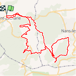
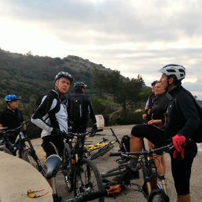
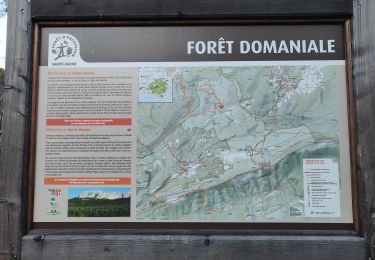
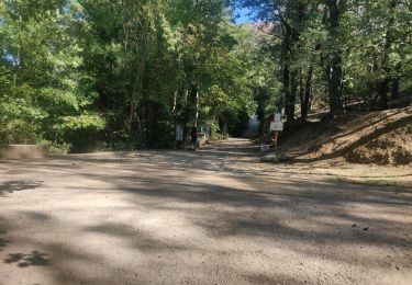
Randonnée V.T.T. de 30 km à découvrir à Provence-Alpes-Côte d'Azur, Var, Saint-Zacharie. Cette randonnée est proposée par JeudaÏ.

Profil altimétrique

Localisation

Pays :
France
Région :
Provence-Alpes-Côte d'Azur
Département/Province :
Var
Commune :
Saint-Zacharie
Localité :
Unknown
Départ:(Dec)
Départ:(UTM)
719245 ; 4807277 (31T) N.

Randonnées à proximité

Randonnée V.T.T. Trets - les contreforts du mont Olympe - Photo
V.T.T.
GUIDE
amiral13

V.T.T.

Facile
(1)
Trets, Provence-Alpes-Côte d'Azur, Bouches-du-Rhône, France
11,8 km | 15,5 km-effort
2h 52min
Oui
Randonnée Marche Auriol - la crete des infernets - Photo
Marche
Coryphene

Marche

Difficile
(1)
Auriol, Provence-Alpes-Côte d'Azur, Bouches-du-Rhône, France
8,6 km | 14 km-effort
3h 22min
Oui
Randonnée Marche Auriol - le ravin des Encanaux - Photo
Marche
GUIDE
amiral13

Marche

Difficile
Auriol, Provence-Alpes-Côte d'Azur, Bouches-du-Rhône, France
7,3 km | 12,2 km-effort
3h 10min
Oui
Randonnée Marche Saint-Zacharie - Source de l'Huveaune  - Photo
Marche
GUIDE
lhomme.ph

Marche

Facile
Saint-Zacharie, Provence-Alpes-Côte d'Azur, Var, France
15,2 km | 19,7 km-effort
4h 24min
Oui
Randonnée Marche Auriol - les Encanaux  - Photo
Marche
cousam

Marche

Difficile
Auriol, Provence-Alpes-Côte d'Azur, Bouches-du-Rhône, France
7,1 km | 11 km-effort
2h 14min
Oui
Randonnée Marche Saint-Zacharie - Sources des Nayes  - Photo
Marche
dudu42

Marche

Moyen
Saint-Zacharie, Provence-Alpes-Côte d'Azur, Var, France
7,6 km | 9,6 km-effort
1h 47min
Oui
Randonnée Marche Auriol - Ravin des Infernets -Tête de chien - Photo
Marche
cousam

Marche

Très difficile
Auriol, Provence-Alpes-Côte d'Azur, Bouches-du-Rhône, France
13,7 km | 22 km-effort
9h 33min
Oui
Randonnée Marche Plan-d'Aups-Sainte-Baume - l'huveaune - Photo
Marche
cousam

Marche

Très difficile
Plan-d'Aups-Sainte-Baume, Provence-Alpes-Côte d'Azur, Var, France
15,4 km | 25 km-effort
7h 52min
Oui
Randonnée Marche Auriol - les Encanaux  - Photo
Marche
Marcsaintcyr

Marche

Moyen
(1)
Auriol, Provence-Alpes-Côte d'Azur, Bouches-du-Rhône, France
12,5 km | 21 km-effort
4h 51min
Oui


Fermer
Mes abonnements