Randonnée Marche Nostang - De Nostang à la pointe du Gouarde - Photo

De Nostang à la pointe du Gouarde

 EricVIBERT
EricVIBERT

Utilisateur

© OpenStreetMap contributors
Longueur
Longueur
9,8 km
Altitude max
Altitude max
23 m
Dénivelé positif
Dénivelé positif
89 m
Km-Effort
Km-Effort  
11 km
Altitude min
Altitude min
-1 m
Dénivelé négatif
Dénivelé négatif
89 m
Boucle
Boucle
Oui
Date de création :
2017-04-09 00:00:00.0
Dernière modification :
2017-04-09 00:00:00.0

(4 Avis)

Marche
Marche
2h36
Difficulté : Facile

Scannez ce code QR pour ouvrir la randonnée dans l'application SityTrail

Application GPS de randonnée GRATUITE

Logo SityTrail SityTrail

IGN / Instituts géographiques

Télécharger SityTrail sur l'App Store Télécharger SityTrail sur Google Play

Logo SityTrail SityTrail World

Le monde est à vous

Télécharger SityTrail sur l'App Store Télécharger SityTrail sur Google Play Télécharger SityTrail sur Huawei AppGallery

À propos

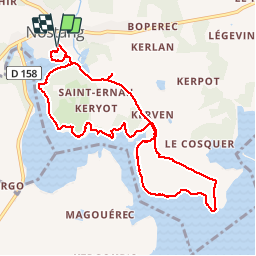
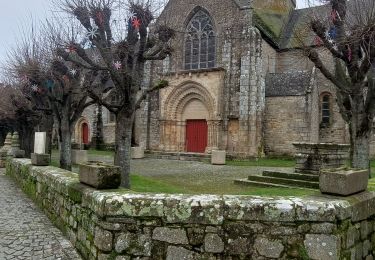
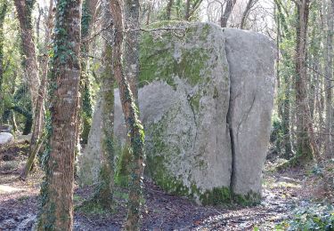
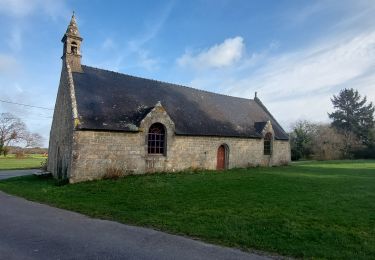
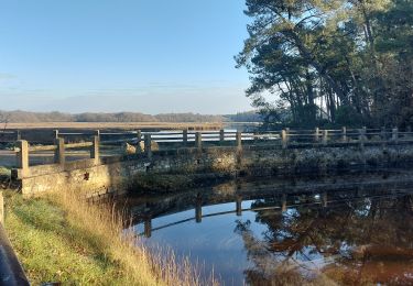
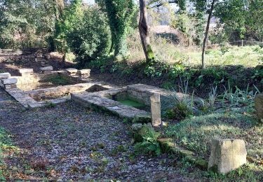
Randonnée Marche de 9,8 km à découvrir à Bretagne, Morbihan, Nostang. Cette randonnée est proposée par EricVIBERT.

Description

vues sur le haut de la Ria d'Etel

Profil altimétrique

Points d'intérêt

Point d'intérêt Nostang - PONTPoint 1 - Photo
EricVIBERT
NOSTANG 
Point d'intérêt Nostang - Point 2RIA - Photo
EricVIBERT
NOSTANG 
Point d'intérêt Nostang - RIAPoint 3 - Photo
EricVIBERT
NOSTANG 
Point d'intérêt Nostang - LA CALEPoint 4 - Photo
EricVIBERT

Localisation

Pays :
France
Région :
Bretagne
Département/Province :
Morbihan
Commune :
Nostang
Localité :
Unknown
Départ:(Dec)
Départ:(UTM)
486022 ; 5288317 (30T) N.

Commentaires

Veuillez vous connecter pour laisser un commentaire ou une note


Très belle randonnée les long de la ria d’Etel. Pas de difficultés. Les portions de route empruntées sont peu passantes.


Randonnées à proximité

Randonnée Vélo Nostang - Nostang  La Gouarde 14/06 - Photo
Vélo
guizouarn

Vélo

Moyen
(1)
Nostang, Bretagne, Morbihan, France
6,8 km | 7,7 km-effort
1h 17min
Oui
Randonnée A pied Nostang - Le Long du Roch - Photo
A pied
PRO

A pied

Facile
Nostang, Bretagne, Morbihan, France
7,5 km | 8,9 km-effort
2h 1min
Oui
Randonnée A pied Sainte-Hélène - Entre bois et landes - Photo
A pied
PRO

A pied

Facile
Sainte-Hélène, Bretagne, Morbihan, France
6,9 km | 7,7 km-effort
1h 44min
Oui
Randonnée A pied Sainte-Hélène - Circuit de Pont Madame - Photo
A pied
PRO

A pied

Facile
Sainte-Hélène, Bretagne, Morbihan, France
5,1 km | 5,8 km-effort
1h 18min
Non
Randonnée Marche Merlevenez - PR_56_Merlevenez_BA_02_Circuit1b_Trevelzun_20240128 - Photo
Marche
patrickdanilo

Marche

Moyen
Merlevenez, Bretagne, Morbihan, France
9,8 km | 10,9 km-effort
2h 28min
Oui
Randonnée Marche Plouhinec - PR_56_Plouhinec_EA_05_Circuit1b_Des-Sous-Bois-De-St-Fiacre_20240106 - Photo
Marche
patrickdanilo

Marche

Très facile
Plouhinec, Bretagne, Morbihan, France
6,8 km | 7,5 km-effort
1h 37min
Oui
Randonnée Marche Plouhinec - PR_56_Plouhinec_DA_04_Circuit4b_De-St-Fiacre-Et-Du-Vamen_20231228 - Photo
Marche
patrickdanilo

Marche

Très facile
Plouhinec, Bretagne, Morbihan, France
9,2 km | 10,2 km-effort
2h 18min
Oui
Randonnée Marche Sainte-Hélène - PR_56_Ste-Helene_CA_03_Circuit1b_Pont-Madame_20231202 - Photo
Marche
patrickdanilo

Marche

Moyen
Sainte-Hélène, Bretagne, Morbihan, France
8,4 km | 9,3 km-effort
1h 37min
Oui
Randonnée Marche Sainte-Hélène - PR_56_Ste-Helene_BA_02_Circuit1b_Entre-Bois-Et-Landes_20231107 - Photo
Marche
patrickdanilo

Marche

Très facile
Sainte-Hélène, Bretagne, Morbihan, France
8,2 km | 9,1 km-effort
1h 40min
Oui


Fermer
Mes abonnements