Randonnée Marche Loubressac - Loubressac loop across the causse - Photo

Loubressac loop across the causse

 panky
panky

Utilisateur

© OpenStreetMap contributors
Longueur
Longueur
12,8 km
Altitude max
Altitude max
418 m
Dénivelé positif
Dénivelé positif
232 m
Km-Effort
Km-Effort  
15,9 km
Altitude min
Altitude min
288 m
Dénivelé négatif
Dénivelé négatif
234 m
Boucle
Boucle
Oui
Date de création :
2017-06-02 00:00:00.0
Dernière modification :
2017-06-02 00:00:00.0

(0 Avis)

Marche
Marche
4h47
Difficulté : Facile

Scannez ce code QR pour ouvrir la randonnée dans l'application SityTrail

Application GPS de randonnée GRATUITE

Logo SityTrail SityTrail

IGN / Instituts géographiques

Télécharger SityTrail sur l'App Store Télécharger SityTrail sur Google Play

Logo SityTrail SityTrail World

Le monde est à vous

Télécharger SityTrail sur l'App Store Télécharger SityTrail sur Google Play Télécharger SityTrail sur Huawei AppGallery

À propos

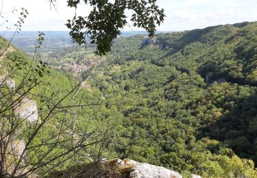
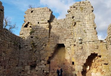
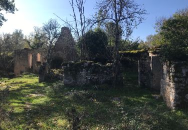
Randonnée Marche de 12,8 km à découvrir à Occitanie, Lot, Loubressac. Cette randonnée est proposée par panky.

Description

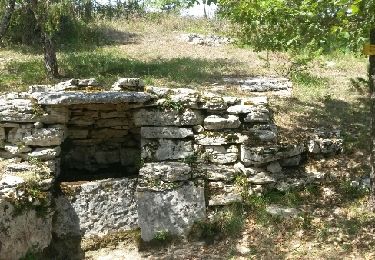
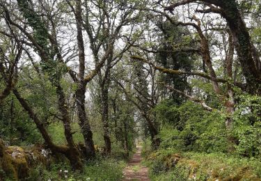
Beautiful views from top of falaises over autoire & gorge, lovely walk along top of causse lots wildflowers & dolmen.

Profil altimétrique

Localisation

Pays :
France
Région :
Occitanie
Département/Province :
Lot
Commune :
Loubressac
Localité :
Unknown
Départ:(Dec)
Départ:(UTM)
405568 ; 4969399 (31T) N.

Randonnées à proximité

Randonnée Marche Loubressac - Nos plus beaux villages - Photo
Marche
alain2306

Marche

Difficile
(1)
Loubressac, Occitanie, Lot, France
9,9 km | 14,2 km-effort
3h 0min
Oui
Randonnée Marche Prudhomat - autour de castelnau - Photo
Marche
lefrancm

Marche

Très facile
(1)
Prudhomat, Occitanie, Lot, France
3,5 km | 4,8 km-effort
1h 48min
Non
Randonnée Marche Loubressac - Loubressac-Château des Anglais - Photo
Marche
werth

Marche

Facile
Loubressac, Occitanie, Lot, France
8,6 km | 12,1 km-effort
2h 21min
Oui
Randonnée A pied Saint-Jean-Lespinasse - St Jean Lespinasse - La Césarine - Photo
A pied
PRO

A pied

Facile
Saint-Jean-Lespinasse, Occitanie, Lot, France
3,8 km | 5,9 km-effort
1h 20min
Oui
Randonnée Marche Carennac - Magnagues - Photo
Marche
Gaillard Isabelle

Marche

Très facile
Carennac, Occitanie, Lot, France
16,8 km | 21 km-effort
4h 51min
Oui
Randonnée Marche Loubressac - autoire cascade siran - Photo
Marche
Forsans

Marche

Moyen
Loubressac, Occitanie, Lot, France
5,5 km | 8,4 km-effort
1h 55min
Non
Randonnée Marche Carennac - Ruines de Taillefer - Photo
Marche
neleda

Marche

Très facile
Carennac, Occitanie, Lot, France
6,4 km | 8,2 km-effort
1h 54min
Non
Randonnée Marche Loubressac - Laguizayrie - Photo
Marche
Gaillard Isabelle

Marche

Facile
Loubressac, Occitanie, Lot, France
15,9 km | 20 km-effort
3h 59min
Oui
Randonnée Marche Saint-Jean-Lespinasse - La Causse de Lauriol - Photo
Marche
richardsimopons

Marche

Saint-Jean-Lespinasse, Occitanie, Lot, France
10,6 km | 14,2 km-effort
3h 6min
Oui


Fermer
Mes abonnements