Randonnée Marche Dinant - GR 129 sud - Photo
 luffi22
luffi22

Utilisateur

© OpenStreetMap contributors
Longueur
Longueur
259 km
Altitude max
Altitude max
463 m
Dénivelé positif
Dénivelé positif
5358 m
Km-Effort
Km-Effort  
329 km
Altitude min
Altitude min
90 m
Dénivelé négatif
Dénivelé négatif
5064 m
Boucle
Boucle
Non
Date de création :
2017-06-07 00:00:00.0
Dernière modification :
2017-06-07 00:00:00.0

(0 Avis)

Marche
Marche
64h26
Difficulté : Difficile

Scannez ce code QR pour ouvrir la randonnée dans l'application SityTrail

Application GPS de randonnée GRATUITE

Logo SityTrail SityTrail

IGN / Instituts géographiques

Télécharger SityTrail sur l'App Store Télécharger SityTrail sur Google Play

Logo SityTrail SityTrail World

Le monde est à vous

Télécharger SityTrail sur l'App Store Télécharger SityTrail sur Google Play Télécharger SityTrail sur Huawei AppGallery

À propos

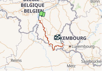
Randonnée Marche de 259 km à découvrir à Wallonie, Namur, Dinant. Cette randonnée est proposée par luffi22.

Description

traverser de Dinant-Arlon

modification d'itinéraire du 18 février 2017 appliquer!

Profil altimétrique

Localisation

Pays :
Belgique
Région :
Wallonie
Département/Province :
Namur
Commune :
Dinant
Localité :
Dinant
Départ:(Dec)
Départ:(UTM)
636001 ; 5569426 (31U) N.

Randonnées à proximité

Randonnée Marche Dinant - RB-Na-24_Anseremme - Photo
Marche
PRO

Marche

Moyen
(14)
Dinant, Wallonie, Namur, Belgique
19,2 km | 26 km-effort
5h 34min
Oui
Randonnée Marche Yvoir - RB-Na-03_Houx - Photo
Marche
PRO

Marche

Difficile
(10)
Yvoir, Wallonie, Namur, Belgique
22 km | 30 km-effort
7h 1min
Oui
Randonnée Marche Onhaye - RB-Na-C2 La vallée du Flavion et le château moyenâgeux de Montaigle - complet - Photo
Marche
PRO

Marche

Très difficile
(2)
Onhaye, Wallonie, Namur, Belgique
20 km | 25 km-effort
5h 25min
Oui
Randonnée Marche Dinant - Balade à Dinant - La Réserve Naturelle de Moniat - Photo
Marche
GUIDE
Desrumaux

Marche

Très facile
(1)
Dinant, Wallonie, Namur, Belgique
8,4 km | 10,9 km-effort
3h 54min
Oui
Randonnée Marche Dinant - D'Anseremme à Dinant - Photo
Marche
GUIDE
Desrumaux

Marche

Facile
(3)
Dinant, Wallonie, Namur, Belgique
8,3 km | 11,8 km-effort
2h 34min
Oui
Randonnée Marche Dinant - Balade à Bouvignes - Photo
Marche
GUIDE
Desrumaux

Marche

Facile
(3)
Dinant, Wallonie, Namur, Belgique
4,8 km | 7,2 km-effort
1h 34min
Oui
Randonnée Marche Dinant - Balade en Réserve Naturelle de Devant Bouvignes - Photo
Marche
GUIDE
Desrumaux

Marche

Très facile
(3)
Dinant, Wallonie, Namur, Belgique
4,9 km | 6,9 km-effort
1h 32min
Oui
Randonnée Marche Dinant - Dinant: autour de la Citadelle.  - Photo
Marche
godi

Marche

Facile
(4)
Dinant, Wallonie, Namur, Belgique
5,7 km | 7,5 km-effort
1h 40min
Oui
Randonnée Marche Onhaye - RB-Na-C2 La vallée du Flavion et le château moyenâgeux de Montaigle - Raccourci - Photo
Marche
PRO

Marche

Difficile
(5)
Onhaye, Wallonie, Namur, Belgique
13 km | 16,2 km-effort
3h 29min
Oui


Fermer
Mes abonnements