Randonnée V.T.T. Pagny-sur-Moselle - Pagny-sur-Moselle_EC_G - Photo
 PhilippeC54
PhilippeC54

Utilisateur

© OpenStreetMap contributors
Longueur
Longueur
24 km
Altitude max
Altitude max
372 m
Dénivelé positif
Dénivelé positif
467 m
Km-Effort
Km-Effort  
30 km
Altitude min
Altitude min
185 m
Dénivelé négatif
Dénivelé négatif
467 m
Boucle
Boucle
Oui
Date de création :
2017-06-13 00:00:00.0
Dernière modification :
2017-06-13 00:00:00.0

(0 Avis)

V.T.T.
V.T.T.
1h58
Difficulté : Moyen

Scannez ce code QR pour ouvrir la randonnée dans l'application SityTrail

Application GPS de randonnée GRATUITE

Logo SityTrail SityTrail

IGN / Instituts géographiques

Télécharger SityTrail sur l'App Store Télécharger SityTrail sur Google Play

Logo SityTrail SityTrail World

Le monde est à vous

Télécharger SityTrail sur l'App Store Télécharger SityTrail sur Google Play Télécharger SityTrail sur Huawei AppGallery

À propos

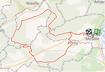
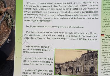
Randonnée V.T.T. de 24 km à découvrir à Grand Est, Meurthe-et-Moselle, Pagny-sur-Moselle. Cette randonnée est proposée par PhilippeC54.

Description

Pour groupe Grands école cyclo

Profil altimétrique

Localisation

Pays :
France
Région :
Grand Est
Département/Province :
Meurthe-et-Moselle
Commune :
Pagny-sur-Moselle
Localité :
Unknown
Départ:(Dec)
Départ:(UTM)
282028 ; 5429794 (32U) N.

Randonnées à proximité

Randonnée A pied Arry - Circuit d'Arry Nord - Photo
A pied
PRO

A pied

Facile
Arry, Grand Est, Moselle, France
3,4 km | 4,2 km-effort
57min
Non
Randonnée Marche Pagny-sur-Moselle - Pagny sur Moselle - Photo
Marche
joelclaudel

Marche

Très facile
(1)
Pagny-sur-Moselle, Grand Est, Meurthe-et-Moselle, France
18,1 km | 23 km-effort
4h 55min
Oui
Randonnée Marche Arry - Arry - côte Saint Pierre - Vezon - Marieulles - Lorry Mardigny - Arry  - Photo
Marche
jean-marie.parachini

Marche

Moyen
Arry, Grand Est, Moselle, France
13,9 km | 18 km-effort
24h 12min
Oui
Randonnée Marche Champey-sur-Moselle - CHAMPEY - LA FRONTIERE - Photo
Marche
jean-marie.parachini

Marche

Facile
Champey-sur-Moselle, Grand Est, Meurthe-et-Moselle, France
10,7 km | 14,5 km-effort
3h 31min
Oui
Randonnée Marche Arnaville - ARNAVILLE - LES AÏTRES MEDIEVAUX - Photo
Marche
jean-marie.parachini

Marche

Facile
Arnaville, Grand Est, Meurthe-et-Moselle, France
12,7 km | 15,6 km-effort
3h 51min
Oui
Randonnée Marche Arnaville - ARNAVILLE - LA VALLEE DU RUPT DE MAD - Photo
Marche
jean-marie.parachini

Marche

Facile
Arnaville, Grand Est, Meurthe-et-Moselle, France
9,9 km | 13,5 km-effort
3h 55min
Oui
Randonnée Marche Pagny-sur-Moselle - PAGNY SUR MOSELLE - VAL ET PLATEAU - Photo
Marche
jean-marie.parachini

Marche

Moyen
Pagny-sur-Moselle, Grand Est, Meurthe-et-Moselle, France
18,1 km | 23 km-effort
6h 46min
Oui
Randonnée Marche Prény - Forêt de Preny dévastée quelle dommage - Photo
Marche
bitiba

Marche

Moyen
Prény, Grand Est, Meurthe-et-Moselle, France
7,4 km | 9,7 km-effort
1h 14min
Non
Randonnée Marche Prény - Marche Prény 2017 - Photo
Marche
pgydbt

Marche

Moyen
(1)
Prény, Grand Est, Meurthe-et-Moselle, France
9,5 km | 13 km-effort
2h 41min
Oui


Fermer
Mes abonnements