Randonnée V.T.T. Châlons-en-Champagne - Châlons Boucle sud - Photo
 Poillerat
Poillerat

Utilisateur

© OpenStreetMap contributors
Longueur
Longueur
38 km
Altitude max
Altitude max
151 m
Dénivelé positif
Dénivelé positif
316 m
Km-Effort
Km-Effort  
42 km
Altitude min
Altitude min
79 m
Dénivelé négatif
Dénivelé négatif
316 m
Boucle
Boucle
Oui
Date de création :
2014-12-10 00:00:00.0
Dernière modification :
2014-12-10 00:00:00.0

(0 Avis)

V.T.T.
V.T.T.
--
Difficulté : Moyen

Scannez ce code QR pour ouvrir la randonnée dans l'application SityTrail

Application GPS de randonnée GRATUITE

Logo SityTrail SityTrail

IGN / Instituts géographiques

Télécharger SityTrail sur l'App Store Télécharger SityTrail sur Google Play

Logo SityTrail SityTrail World

Le monde est à vous

Télécharger SityTrail sur l'App Store Télécharger SityTrail sur Google Play Télécharger SityTrail sur Huawei AppGallery

À propos

Randonnée V.T.T. de 38 km à découvrir à Grand Est, Marne, Châlons-en-Champagne. Cette randonnée est proposée par Poillerat.

Profil altimétrique

Localisation

Pays :
France
Région :
Grand Est
Département/Province :
Marne
Commune :
Châlons-en-Champagne
Localité :
Unknown
Départ:(Dec)
Départ:(UTM)
599887 ; 5423543 (31U) N.

Randonnées à proximité

Randonnée V.T.T. Châlons-en-Champagne - Vallée et Champagne crayeuse - Photo
V.T.T.
tracegps

V.T.T.

Moyen
(1)
Châlons-en-Champagne, Grand Est, Marne, France
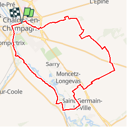
35 km | 38 km-effort
2h 30min
Oui
Randonnée Vélo électrique Châlons-en-Champagne - Chalons en Champagne Vitry le François  - Photo
Vélo électrique
FPortier

Vélo électrique

Très facile
Châlons-en-Champagne, Grand Est, Marne, France
32 km | 34 km-effort
3h 25min
Non
Randonnée Marche Châlons-en-Champagne - La Via Francigena - Châlons en Champagne- Vitry le François - Photo
Marche
tracegps

Marche

Moyen
Châlons-en-Champagne, Grand Est, Marne, France
45 km | 49 km-effort
10h 0min
Non
Randonnée Marche Châlons-en-Champagne - Chemin de Compostelle, Voie de Vézelay GR654® De Châlons en Champagne à La Chaussée sur Marne - Photo
Marche
tracegps

Marche

Difficile
Châlons-en-Champagne, Grand Est, Marne, France
24 km | 26 km-effort
4h 49min
Non
Randonnée Marche nordique Châlons-en-Champagne - Châlons en Champagnbe 10 620m +54m - Photo
Marche nordique
DanielROLLET

Marche nordique

Facile
Châlons-en-Champagne, Grand Est, Marne, France
10,6 km | 11,3 km-effort
2h 20min
Oui
Randonnée Cyclotourisme Châlons-en-Champagne - Chalons - Sainte-Marie du Lac 62 km - Photo
Cyclotourisme
GUIDE
jeanmarcMasson

Cyclotourisme

Très difficile
Châlons-en-Champagne, Grand Est, Marne, France
62 km | 66 km-effort
4h 31min
Non
Randonnée Vélo Châlons-en-Champagne - 20070610Arcis - Photo
Vélo
gpstracks

Vélo

Très facile
Châlons-en-Champagne, Grand Est, Marne, France
62 km | 68 km-effort
Inconnu
Non
Randonnée Marche nordique Recy - recy 10,5 km 13 02 2024 - Photo
Marche nordique
riri51

Marche nordique

Très facile
Recy, Grand Est, Marne, France
10,7 km | 11,5 km-effort
2h 4min
Oui
Randonnée Marche Châlons-en-Champagne - L'Epine 19 500m +130m - Photo
Marche
DanielROLLET

Marche

Très difficile
Châlons-en-Champagne, Grand Est, Marne, France
19,5 km | 21 km-effort
4h 41min
Oui


Fermer
Mes abonnements