Randonnée Course à pied Saint-Léger-Vauban - la pierre qui vire - Photo
 dadodeca
dadodeca

Utilisateur

© OpenStreetMap contributors
Longueur
Longueur
29 km
Altitude max
Altitude max
565 m
Dénivelé positif
Dénivelé positif
741 m
Km-Effort
Km-Effort  
39 km
Altitude min
Altitude min
260 m
Dénivelé négatif
Dénivelé négatif
897 m
Boucle
Boucle
Non
Date de création :
2018-06-26 15:47:32.357
Dernière modification :
2018-06-26 15:47:32.357

(0 Avis)

Course à pied
Course à pied
2h06
Difficulté : Moyen

Scannez ce code QR pour ouvrir la randonnée dans l'application SityTrail

Application GPS de randonnée GRATUITE

Logo SityTrail SityTrail

IGN / Instituts géographiques

Télécharger SityTrail sur l'App Store Télécharger SityTrail sur Google Play

Logo SityTrail SityTrail World

Le monde est à vous

Télécharger SityTrail sur l'App Store Télécharger SityTrail sur Google Play Télécharger SityTrail sur Huawei AppGallery

À propos

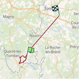
Randonnée Course à pied de 29 km à découvrir à Bourgogne-Franche-Comté, Yonne, Saint-Léger-Vauban. Cette randonnée est proposée par dadodeca.

Description

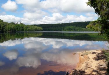
Brizards et Trinquelin. Trace GPS non fiable sur plusieurs portions après les Brizards et dans gorges du Trinquelin ainsi que la fin. réel 12km et 310m

Profil altimétrique

Photos

Localisation

Pays :
France
Région :
Bourgogne-Franche-Comté
Département/Province :
Yonne
Commune :
Saint-Léger-Vauban
Localité :
Unknown
Départ:(Dec)
Départ:(UTM)
580110 ; 5245622 (31T) N.

Randonnées à proximité

Randonnée Marche Saint-Agnan - tour de st agnan - Photo
Marche
famillerudent

Marche

Facile
Saint-Agnan, Bourgogne-Franche-Comté, Nièvre, France
8,8 km | 10,5 km-effort
2h 1min
Oui
Randonnée Marche Saint-Léger-Vauban - Abbaye-Quarre-Abbaye - Photo
Marche
Yannick89

Marche

Très facile
Saint-Léger-Vauban, Bourgogne-Franche-Comté, Yonne, France
19,2 km | 25 km-effort
5h 12min
Oui
Randonnée Marche Saint-Agnan - Saint Agnan - Photo
Marche
GUIDE
lucclaes

Marche

Très difficile
Saint-Agnan, Bourgogne-Franche-Comté, Nièvre, France
23 km | 30 km-effort
6h 50min
Oui
Randonnée Marche Saint-Agnan - saint agnan - Photo
Marche
bougnaou

Marche

Très facile
Saint-Agnan, Bourgogne-Franche-Comté, Nièvre, France
9,7 km | 11,5 km-effort
2h 48min
Oui
Randonnée V.T.T. Quarré-les-Tombes - Grande Traversée du Morvan : Quarré les Tombes - Saulieu - Photo
V.T.T.
tracegps

V.T.T.

Difficile
Quarré-les-Tombes, Bourgogne-Franche-Comté, Yonne, France
46 km | 59 km-effort
5h 30min
Non
Randonnée V.T.T. Saint-Agnan - Espace VTT FFC Parc du Morvan - Circuit n°23 - Saint Agnan - Photo
V.T.T.
tracegps

V.T.T.

Facile
(1)
Saint-Agnan, Bourgogne-Franche-Comté, Nièvre, France
8,9 km | 10,7 km-effort
40min
Oui
Randonnée Marche Saint-Agnan - lac St Agnan  - Photo
Marche
lepompi

Marche

Moyen
Saint-Agnan, Bourgogne-Franche-Comté, Nièvre, France
8,5 km | 10,1 km-effort
2h 6min
Oui
Randonnée Marche Saint-Agnan - Tourdu lac de St Agnan - Photo
Marche
Benteux

Marche

Très facile
Saint-Agnan, Bourgogne-Franche-Comté, Nièvre, France
8,5 km | 10,1 km-effort
2h 17min
Oui
Randonnée V.T.T. Quarré-les-Tombes - 2 Quarré Saulieu montsauche les Settons 80km 1613m D+ - Photo
V.T.T.
topolino

V.T.T.

Très difficile
Quarré-les-Tombes, Bourgogne-Franche-Comté, Yonne, France
80 km | 101 km-effort
7h 1min
Non


Fermer
Mes abonnements