Trail Mountain bike Val-des-Prés - Montgenèvre et col de la Lauze - Photo
 tracegps
tracegps

User

© OpenStreetMap contributors
Length
Length
38 km
Max alt
Max alt
2515 m
Uphill gradient
Uphill gradient
1444 m
Km-Effort
Km-Effort  
57 km
Min alt
Min alt
1356 m
Downhill gradient
Downhill gradient
1444 m
Boucle
Boucle
Yes
Creation date :
2014-12-10 00:00:00.0
Updated on :
2014-12-10 00:00:00.0

(1 Reviews)

Mountain bike
Mountain bike
3h30
Difficulty : Very difficult

Scan this QR Code to open this trail in the SityTrail application

FREE GPS app for hiking

Logo SityTrail SityTrail

IGN / Geographical institutes

Download SityTrail from the App Store Download SityTrail from Google Play

Logo SityTrail SityTrail World

The world is yours!

Download SityTrail from the App Store Download SityTrail from Google Play Download SityTrail on Huawei AppGallery

About

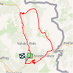
Trail Mountain bike of 38 km to be discovered at Provence-Alpes-Côte d'Azur, Hautes-Alpes, Val-des-Prés. This trail is proposed by tracegps.

Description

03 Aout 2005 Reprise des VTT, Ludo nous emmène sur l’une des boucles de la coupe de France de VTT marathon de Montgenèvre, temps de nouveau beau et paysages superbes, après le Col de la Lauze et sa descente, retour à partir de Plampinet avec Soph qui assurera un train pas si reposant ! Toutes les détails ICI

Elevation profile

Photos

Positioning

Country:
France
Region :
Provence-Alpes-Côte d'Azur
Department/Province :
Hautes-Alpes
Municipality :
Val-des-Prés
Location:
Unknown
Start:(UTM)
316490 ; 4976632 (32T) N.

Comments

Please log in to post a review or rate the element


beau circuit (je suis assez ce matin et la trace est encore bien roulable)


Trails nearby

Trail Walking Briançon - Briançon Schappe-3 têtes - Photo
Walking
Orcal37

Walking

Easy
(2)
Briançon, Provence-Alpes-Côte d'Azur, Hautes-Alpes, France
6.5 km | 11 km-effort
2h 5min
Yes
Trail Walking Montgenèvre - Les crêtes du Chalvet - Photo
Walking
GUIDE
amiral13

Walking

Medium
Montgenèvre, Provence-Alpes-Côte d'Azur, Hautes-Alpes, France
12 km | 23 km-effort
6h 3min
Yes
Trail Walking Val-des-Prés - le Chenaillet et le grand charvia - Photo
Walking
GUIDE
amiral13

Walking

Medium
Val-des-Prés, Provence-Alpes-Côte d'Azur, Hautes-Alpes, France
11.3 km | 19.5 km-effort
4h 17min
No
Trail Walking Montgenèvre - le sommet de Château Jouan et le fort de Janus - Photo
Walking
GUIDE
amiral13

Walking

Difficult
Montgenèvre, Provence-Alpes-Côte d'Azur, Hautes-Alpes, France
13.8 km | 24 km-effort
4h 15min
Yes
Trail Walking Briançon - Circuit: Fort des 3 Têtes et Fort Dauphin - Photo
Walking
GUIDE
lhomme.ph

Walking

Easy
(2)
Briançon, Provence-Alpes-Côte d'Azur, Hautes-Alpes, France
7.4 km | 11.9 km-effort
2h 40min
Yes
Trail Walking Briançon - Briancon: Fort des Trois tètes - Photo
Walking
GUIDE
lhomme.ph

Walking

Very easy
Briançon, Provence-Alpes-Côte d'Azur, Hautes-Alpes, France
5 km | 8.5 km-effort
2h 8min
Yes
Trail Walking Briançon - Briancon: Le tour du Fort des 3 Têtes   - Photo
Walking
GUIDE
lhomme.ph

Walking

Medium
(1)
Briançon, Provence-Alpes-Côte d'Azur, Hautes-Alpes, France
7.7 km | 12.7 km-effort
1h 50min
Yes
Trail Mountain bike Montgenèvre - tour de montgenevre - Photo
Mountain bike
Vincentetourmy

Mountain bike

Very difficult
(1)
Montgenèvre, Provence-Alpes-Côte d'Azur, Hautes-Alpes, France
32 km | 50 km-effort
3h 15min
Yes
Trail Mountain bike Briançon - Briançon -Fort Gondran -Montgenevre  - Photo
Mountain bike
delalex

Mountain bike

Difficult
Briançon, Provence-Alpes-Côte d'Azur, Hautes-Alpes, France
24 km | 33 km-effort
2h 16min
No


Close
My subscriptions