Trail Mountain bike Champcella - Espace VTT FFC Pays des Ecrins - Circuit n°10 - Circuit de Rame - Photo

Espace VTT FFC Pays des Ecrins - Circuit n°10 - Circuit de Rame

 tracegps
tracegps

User

© OpenStreetMap contributors
Length
Length
4.1 km
Max alt
Max alt
941 m
Uphill gradient
Uphill gradient
35 m
Km-Effort
Km-Effort  
4.6 km
Min alt
Min alt
919 m
Downhill gradient
Downhill gradient
32 m
Boucle
Boucle
Yes
Creation date :
2014-12-10 00:00:00.0
Updated on :
2014-12-10 00:00:00.0

(0 Reviews)

Mountain bike
Mountain bike
19m
Difficulty : Easy

Scan this QR Code to open this trail in the SityTrail application

FREE GPS app for hiking

Logo SityTrail SityTrail

IGN / Geographical institutes

Download SityTrail from the App Store Download SityTrail from Google Play

Logo SityTrail SityTrail World

The world is yours!

Download SityTrail from the App Store Download SityTrail from Google Play Download SityTrail on Huawei AppGallery

About

Trail Mountain bike of 4.1 km to be discovered at Provence-Alpes-Côte d'Azur, Hautes-Alpes, Champcella. This trail is proposed by tracegps.

Description

Espace VTT FFC Pays des Ecrins Circuit labellisé par la Fédération Française de Cyclisme. Espace VTT FFC Pays des Ecrins – Circuit n°10 - Circuit de Rame Téléchargez le Topo Guide des circuits VTT FFC du Pays des Ecrins.

Elevation profile

Photos

Positioning

Country:
France
Region :
Provence-Alpes-Côte d'Azur
Department/Province :
Hautes-Alpes
Municipality :
Champcella
Location:
Unknown
Start:(UTM)
308111 ; 4956676 (32T) N.

Trails nearby

Trail Walking Freissinières - crête en bordure vallée Freissinieres - Photo
Walking
gildascb

Walking

Medium
(2)
Freissinières, Provence-Alpes-Côte d'Azur, Hautes-Alpes, France
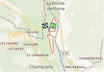
14.7 km | 26 km-effort
4h 52min
Yes
Trail Walking Champcella - Gouffre de Gourfouran - Photo
Walking
CYCLOHC

Walking

Easy
(2)
Champcella, Provence-Alpes-Côte d'Azur, Hautes-Alpes, France
5.1 km | 8.1 km-effort
2h 2min
Yes
Trail Walking Champcella - FRESSINIERES - SEYES 16.3KM - Photo
Walking
jpb83

Walking

Medium
(1)
Champcella, Provence-Alpes-Côte d'Azur, Hautes-Alpes, France
16.3 km | 28 km-effort
5h 44min
Yes
Trail Walking La Roche-de-Rame - Lac de l'Ascension - La Roche de Rame - Photo
Walking
tracegps

Walking

Difficult
(1)
La Roche-de-Rame, Provence-Alpes-Côte d'Azur, Hautes-Alpes, France
14.3 km | 25 km-effort
4h 30min
Yes
Trail Mountain bike Freissinières - traversée fressiniere reotier - Photo
Mountain bike
tchoua

Mountain bike

Difficult
Freissinières, Provence-Alpes-Côte d'Azur, Hautes-Alpes, France
36 km | 52 km-effort
3h 32min
Yes
Trail Touring skiing Champcella - Bienvenue à la citadelle de Roche Charnière au Ponteil - Photo
Touring skiing
tchoua

Touring skiing

Difficult
Champcella, Provence-Alpes-Côte d'Azur, Hautes-Alpes, France
10.1 km | 22 km-effort
2h 46min
Yes
Trail Walking Freissinières - tour de fressiniere - Photo
Walking
tchoua

Walking

Medium
Freissinières, Provence-Alpes-Côte d'Azur, Hautes-Alpes, France
25 km | 43 km-effort
6h 16min
Yes
Trail Walking Saint-Crépin - St Crépin Thurifère vers hameau de Guion Chantal - Photo
Walking
damlou

Walking

Difficult
Saint-Crépin, Provence-Alpes-Côte d'Azur, Hautes-Alpes, France
5 km | 9.9 km-effort
2h 30min
Yes
Trail Walking La Roche-de-Rame - la grande barre par cabane des aiguilles  - Photo
Walking
tchoua

Walking

Very difficult
La Roche-de-Rame, Provence-Alpes-Côte d'Azur, Hautes-Alpes, France
13.7 km | 27 km-effort
3h 34min
Yes


Close
My subscriptions