Trail Walking Burlats - billets l'Agout 18kms 577m 4h30 - Photo

billets l'Agout 18kms 577m 4h30

 guiller
guiller

User

© OpenStreetMap contributors
Length
Length
18.2 km
Max alt
Max alt
447 m
Uphill gradient
Uphill gradient
521 m
Km-Effort
Km-Effort  
25 km
Min alt
Min alt
178 m
Downhill gradient
Downhill gradient
520 m
Boucle
Boucle
Yes
Creation date :
2019-01-15 14:58:06.935
Updated on :
2019-01-15 14:58:06.935

(0 Reviews)

Walking
Walking
4h44
Difficulty : Easy

Scan this QR Code to open this trail in the SityTrail application

FREE GPS app for hiking

Logo SityTrail SityTrail

IGN / Geographical institutes

Download SityTrail from the App Store Download SityTrail from Google Play

Logo SityTrail SityTrail World

The world is yours!

Download SityTrail from the App Store Download SityTrail from Google Play Download SityTrail on Huawei AppGallery

About

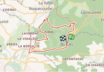
Trail Walking of 18.2 km to be discovered at Occitania, Tarn, Burlats. This trail is proposed by guiller.

Description

beau parcours ombragé, peut être réalisé par températures élevées, nombreux points d'eau pour les chiens

Elevation profile

Photos

Points of interest

Point of interest Burlats - Point 10 - Photo
guiller
BURLATS 

Positioning

Country:
France
Region :
Occitania
Department/Province :
Tarn
Municipality :
Burlats
Location:
Unknown
Start:(UTM)
445065 ; 4831813 (31T) N.

Trails nearby

Trail Walking Lacrouzette - les rochers de sidobre  - Photo
Walking
leroj73

Walking

Very easy
(1)
Lacrouzette, Occitania, Tarn, France
11.9 km | 15.5 km-effort
3h 31min
Yes
Trail Walking Lacrouzette - OR-7523970--Lacrouzette:2017-06-10 Sidobre rocs de crémaussel et Lac du Merle - Photo
Walking
cappelle

Walking

Very difficult
(1)
Lacrouzette, Occitania, Tarn, France
15.6 km | 21 km-effort
4h 39min
Yes
Trail On foot Lacrouzette - les rochers du sidobre - Photo
On foot
leroj73

On foot

Very easy
(1)
Lacrouzette, Occitania, Tarn, France
11.2 km | 15.2 km-effort
Unknown
Yes
Trail Mountain bike Lacrouzette - Lacrouzette VTT 2016 - Photo
Mountain bike
J-Mi

Mountain bike

Easy
(3)
Lacrouzette, Occitania, Tarn, France
32 km | 41 km-effort
2h 36min
Yes
Trail Mountain bike Lacrouzette - Ronde des rochers 2008 - Photo
Mountain bike
tracegps

Mountain bike

Medium
(1)
Lacrouzette, Occitania, Tarn, France
30 km | 39 km-effort
2h 15min
Yes
Trail On foot Burlats - Chemin des Fontaines - Photo
On foot
PRO

On foot

Easy
Burlats, Occitania, Tarn, France
7.3 km | 8.5 km-effort
1h 55min
No
Trail Walking Burlats - Burlats cascade de la truite - Photo
Walking
poisson1103

Walking

Medium
Burlats, Occitania, Tarn, France
19.3 km | 30 km-effort
5h 22min
No
Trail Mountain bike Castres - 20141119_123639 - Photo
Mountain bike
boraumir

Mountain bike

Easy
(1)
Castres, Occitania, Tarn, France
16.2 km | 21 km-effort
1h 35min
Yes
Trail Walking Noailhac - 81-Prades-Fialessuch -30/03/2014 - Photo
Walking
Jovila

Walking

Easy
Noailhac, Occitania, Tarn, France
11.4 km | 16.7 km-effort
3h 4min
Yes


Close
My subscriptions