Trail Walking Souchez - Souchez Lorette Carency - Photo

Souchez Lorette Carency

 tracegps
tracegps

User

© OpenStreetMap contributors
Length
Length
9.7 km
Max alt
Max alt
173 m
Uphill gradient
Uphill gradient
165 m
Km-Effort
Km-Effort  
11.9 km
Min alt
Min alt
74 m
Downhill gradient
Downhill gradient
164 m
Boucle
Boucle
Yes
Creation date :
2014-12-10 00:00:00.0
Updated on :
2014-12-10 00:00:00.0

(0 Reviews)

Walking
Walking
2h00
Difficulty : Medium

Scan this QR Code to open this trail in the SityTrail application

FREE GPS app for hiking

Logo SityTrail SityTrail

IGN / Geographical institutes

Download SityTrail from the App Store Download SityTrail from Google Play

Logo SityTrail SityTrail World

The world is yours!

Download SityTrail from the App Store Download SityTrail from Google Play Download SityTrail on Huawei AppGallery

About

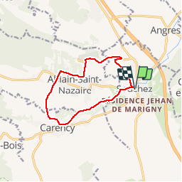
Trail Walking of 9.7 km to be discovered at Hauts-de-France, Pas-de-Calais, Souchez. This trail is proposed by tracegps.

Description

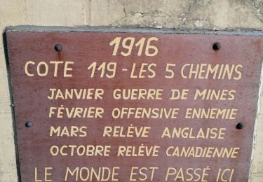
Randonnée au départ de Souchez qui monte au cimetière de Notre Dame de Lorette redescend sur Ablain St Nazaire, passe par Carency et rejoint Souchez.

Elevation profile

Photos

Positioning

Country:
France
Region :
Hauts-de-France
Department/Province :
Pas-de-Calais
Municipality :
Souchez
Location:
Unknown
Start:(UTM)
481618 ; 5582115 (31U) N.

Comments

Please log in to post a review or rate the element


Belle marche Ça grimpe pour Madame surtout quand on le fait à l'envers Détour par l'anneau de la mémoire Emouvant


Trails nearby

Trail Walking Mont-Saint-Éloi - Autour du Mont-Saint-Éloi - Photo
Walking
tracegps

Walking

Difficult
(3)
Mont-Saint-Éloi, Hauts-de-France, Pas-de-Calais, France
14.3 km | 16.7 km-effort
3h 34min
Yes
Trail Walking Liévin - 50 km Lievin en nocturne - Photo
Walking
tracegps

Walking

Very difficult
(1)
Liévin, Hauts-de-France, Pas-de-Calais, France
52 km | 61 km-effort
9h 0min
Yes
Trail Nordic walking Mont-Saint-Éloi - Les trois abbayes  - Photo
Nordic walking
Castor65

Nordic walking

Easy
Mont-Saint-Éloi, Hauts-de-France, Pas-de-Calais, France
16.2 km | 18.9 km-effort
3h 24min
Yes
Trail Walking Angres - randonnée pinchonvalles - Photo
Walking
Chene62

Walking

Very difficult
Angres, Hauts-de-France, Pas-de-Calais, France
27 km | 0 m-effort
3h 24min
No
Trail Other activity Liévin - boucle Liévin - Photo
Other activity
crijack

Other activity

Very easy
Liévin, Hauts-de-France, Pas-de-Calais, France
11 km | 12.3 km-effort
2h 2min
Yes
Trail Other activity Liévin - boucle Liévin - Photo
Other activity
crijack

Other activity

Very easy
Liévin, Hauts-de-France, Pas-de-Calais, France
11 km | 12.3 km-effort
2h 2min
Yes
Trail Running Aix-Noulette - aix noulette sity guide 25,3 km D530+ - Photo
Running
jamboxland

Running

Medium
Aix-Noulette, Hauts-de-France, Pas-de-Calais, France
23 km | 30 km-effort
2h 45min
Yes
Trail Walking Neuville-Saint-Vaast - tour Neuville p1 - Photo
Walking
Gilbert62580

Walking

Easy
Neuville-Saint-Vaast, Hauts-de-France, Pas-de-Calais, France
4 km | 4.5 km-effort
1h 1min
No
Trail Walking Souchez - Souchez-Noulette-Lorette-Ablain - Photo
Walking
tracegps

Walking

Easy
Souchez, Hauts-de-France, Pas-de-Calais, France
6.7 km | 8.4 km-effort
1h 45min
Yes


Close
My subscriptions