Trail Mountain bike Alençon - Croix de Médavy, Signal d'Ecouves et Croix Madame. - Photo

Croix de Médavy, Signal d'Ecouves et Croix Madame.

 tracegps
tracegps

User

© OpenStreetMap contributors
Length
Length
44 km
Max alt
Max alt
426 m
Uphill gradient
Uphill gradient
743 m
Km-Effort
Km-Effort  
54 km
Min alt
Min alt
141 m
Downhill gradient
Downhill gradient
745 m
Boucle
Boucle
Yes
Creation date :
2014-12-10 00:00:00.0
Updated on :
2014-12-10 00:00:00.0

(0 Reviews)

Mountain bike
Mountain bike
2h15
Difficulty : Medium

Scan this QR Code to open this trail in the SityTrail application

FREE GPS app for hiking

Logo SityTrail SityTrail

IGN / Geographical institutes

Download SityTrail from the App Store Download SityTrail from Google Play

Logo SityTrail SityTrail World

The world is yours!

Download SityTrail from the App Store Download SityTrail from Google Play Download SityTrail on Huawei AppGallery

About

Trail Mountain bike of 44 km to be discovered at Normandy, Orne, Alençon. This trail is proposed by tracegps.

Description

Cette boucle au départ d'Alençon vous propose de pédaler à travers la forêt d'Écouves en passant par la Croix de Médavy, le signal d'Écouves (point culminant du massif forestier) et par le carrefour de la Croix Madame. Quelques montées avec ponctuellement de gros pourcentages et beaucoup de petits sentiers rendant le parcours très agréable surtout par temps sec. La descente de la Croix Madame à la plaine est assez longue et par endroit cassante. Mais elle reste très ludique et agréable. Le retour à Alençon se fait par le chemin habituel et ne présente aucune difficulté.

Elevation profile

Positioning

Country:
France
Region :
Normandy
Department/Province :
Orne
Municipality :
Alençon
Location:
Unknown
Start:(UTM)
284283 ; 5368718 (31U) N.

Trails nearby

Trail Walking Arçonnay - Arconnay - Photo
Walking
jackls

Walking

Medium
(1)
Arçonnay, Pays de la Loire, Sarthe, France
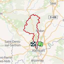
25 km | 28 km-effort
5h 28min
Yes
Trail Mountain bike Alençon - Montée à la croix de Médavy par route et descente par GR et chemins - Photo
Mountain bike
tracegps

Mountain bike

Easy
(1)
Alençon, Normandy, Orne, France
33 km | 40 km-effort
1h 34min
Yes
Trail Cycle Alençon - Véloscénie 3ème étape  - Photo
Cycle
destras

Cycle

Easy
Alençon, Normandy, Orne, France
116 km | 133 km-effort
7h 29min
No
Trail Mountain bike Saint-Germain-du-Corbéis - Le bois  de vaux - Photo
Mountain bike
yvesportier

Mountain bike

Medium
(2)
Saint-Germain-du-Corbéis, Normandy, Orne, France
35 km | 39 km-effort
2h 16min
Yes
Trail Mountain bike Saint-Germain-du-Corbéis - chapelle St Evroult/château de Vaux - Photo
Mountain bike
yvesportier

Mountain bike

Medium
(1)
Saint-Germain-du-Corbéis, Normandy, Orne, France
34 km | 39 km-effort
2h 8min
Yes
Trail Cycle Alençon - Alençon, Héloup, Gesnes le Gandelin, Arçonnay, Alençon - Photo
Cycle
tracegps

Cycle

Medium
Alençon, Normandy, Orne, France
30 km | 33 km-effort
1h 10min
Yes
Trail Bicycle tourism Alençon - La véloscénie - Alencon - Madré - Tronçon 1 - Photo
Bicycle tourism
GUIDE
jeanmarcMasson

Bicycle tourism

Very difficult
Alençon, Normandy, Orne, France
40 km | 45 km-effort
Unknown
No
Trail Bicycle tourism Alençon - Activity - Photo
Bicycle tourism
GUIDE
jeanmarcMasson

Bicycle tourism

Very difficult
Alençon, Normandy, Orne, France
155 km | 173 km-effort
Unknown
No
Trail Walking Saint-Paterne - Le Chevain - brullemail - Photo
Walking
Béa57

Walking

Very difficult
Saint-Paterne - Le Chevain, Pays de la Loire, Sarthe, France
40 km | 46 km-effort
4h 24min
No


Close
My subscriptions