Trail Walking Dommarien - Le creux de la Chaudière - Dommarien - Chassigny - Photo

Le creux de la Chaudière - Dommarien - Chassigny

 tracegps
tracegps

User

© OpenStreetMap contributors
Length
Length
13.1 km
Max alt
Max alt
360 m
Uphill gradient
Uphill gradient
199 m
Km-Effort
Km-Effort  
15.8 km
Min alt
Min alt
271 m
Downhill gradient
Downhill gradient
199 m
Boucle
Boucle
Yes
Creation date :
2014-12-10 00:00:00.0
Updated on :
2014-12-10 00:00:00.0

(0 Reviews)

Walking
Walking
4h00
Difficulty : Difficult

Scan this QR Code to open this trail in the SityTrail application

FREE GPS app for hiking

Logo SityTrail SityTrail

IGN / Geographical institutes

Download SityTrail from the App Store Download SityTrail from Google Play

Logo SityTrail SityTrail World

The world is yours!

Download SityTrail from the App Store Download SityTrail from Google Play Download SityTrail on Huawei AppGallery

About

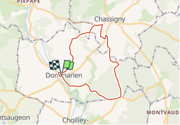
Trail Walking of 13.1 km to be discovered at Grand Est, Haute-Marne, Dommarien. This trail is proposed by tracegps.

Description

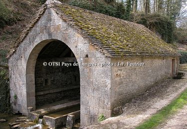
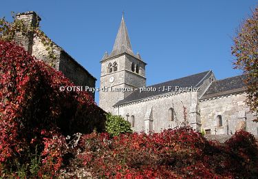
Office de Tourisme du Pays de Langres Circuit balisé. La Randonnée est le plus sûr moyen pour découvrir les secrets du Pays de Langres et des 4 lacs, ses villages entre Champagne et Bourgogne, ses légendes, sa nature généreuse, et bien d’autres surprises encore… Du camping de Dommarien, prendre la direction du village en traversant le pont. Tourner ensuite à droite et poursuivre jusqu’à la sortie du village. Prendre à gauche, passer devant une exploitation agricole et continuer jusqu’au prochain carrefour de chemin.. La suite est téléchargeable ICI Nota : Les données de l'OT du Pays de Langres sont officielles et restent la référence; toute différence dans le kilométrage provient d'un décalage de calcul entre les différents logiciels.

Elevation profile

Photos

Positioning

Country:
France
Region :
Grand Est
Department/Province :
Haute-Marne
Municipality :
Dommarien
Location:
Unknown
Start:(UTM)
676016 ; 5284092 (31T) N.

Trails nearby

Trail Cycle Le Montsaugeonnais - De la Coulange au Badin - Vaux - sous - Aubigny - Photo
Cycle
tracegps

Cycle

Medium
Le Montsaugeonnais, Grand Est, Haute-Marne, France
30 km | 36 km-effort
2h 30min
Yes
Trail Walking Le Montsaugeonnais - Dans les Bois de Montanson - Vaux sous Aubigny - Photo
Walking
tracegps

Walking

Medium
Le Montsaugeonnais, Grand Est, Haute-Marne, France
11.2 km | 15.1 km-effort
2h 30min
Yes
Trail Mountain bike Le Montsaugeonnais - Les Grandes Charmes - Photo
Mountain bike
tracegps

Mountain bike

Medium
Le Montsaugeonnais, Grand Est, Haute-Marne, France
16.2 km | 20 km-effort
2h 0min
Yes
Trail Walking Le Montsaugeonnais - Les Grandes Charmes - Photo
Walking
tracegps

Walking

Difficult
Le Montsaugeonnais, Grand Est, Haute-Marne, France
16.2 km | 20 km-effort
4h 0min
Yes
Trail Mountain bike Dommarien - Le creux de la Chaudière - Dommarien - Chassigny - Photo
Mountain bike
tracegps

Mountain bike

Medium
Dommarien, Grand Est, Haute-Marne, France
13.1 km | 15.8 km-effort
1h 45min
Yes


Close
My subscriptions