Trail Walking Roquebrune-sur-Argens - 20190206 Petites Maures 2ème edition - Photo

20190206 Petites Maures 2ème edition

 Sugg
Sugg

User

© OpenStreetMap contributors
Length
Length
15.9 km
Max alt
Max alt
247 m
Uphill gradient
Uphill gradient
531 m
Km-Effort
Km-Effort  
23 km
Min alt
Min alt
4 m
Downhill gradient
Downhill gradient
530 m
Boucle
Boucle
Yes
Creation date :
2019-03-22 16:57:34.558
Updated on :
2019-03-22 16:57:34.558

(0 Reviews)

Walking
Walking
4h49
Difficulty : Medium

Scan this QR Code to open this trail in the SityTrail application

FREE GPS app for hiking

Logo SityTrail SityTrail

IGN / Geographical institutes

Download SityTrail from the App Store Download SityTrail from Google Play

Logo SityTrail SityTrail World

The world is yours!

Download SityTrail from the App Store Download SityTrail from Google Play Download SityTrail on Huawei AppGallery

About

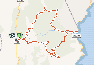
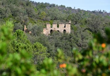
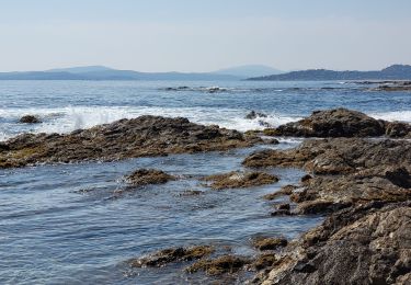
Trail Walking of 15.9 km to be discovered at Provence-Alpes-Côte d'Azur, Var, Roquebrune-sur-Argens. This trail is proposed by Sugg.

Description

6 février 2019. Rando guidée par Pierre
20 randonneurs
réédition de 2016 avec variante car pic-nic sur la plage
Beau temps

Elevation profile

Photos

Positioning

Country:
France
Region :
Provence-Alpes-Côte d'Azur
Department/Province :
Var
Municipality :
Roquebrune-sur-Argens
Location:
Unknown
Start:(UTM)
311465 ; 4803792 (32T) N.

Trails nearby

Trail Walking Fréjus - Etang de Villepey - Photo
Walking
marmotte83

Walking

Very easy
(2)
Fréjus, Provence-Alpes-Côte d'Azur, Var, France
6.5 km | 7 km-effort
3h 4min
Yes
Trail Walking Sainte-Maxime - la baumette - Photo
Walking
perrucheone

Walking

Easy
(1)
Sainte-Maxime, Provence-Alpes-Côte d'Azur, Var, France
8.1 km | 10.6 km-effort
2h 25min
Yes
Trail Walking Roquebrune-sur-Argens - 200526 Les Issambres - Photo
Walking
bebenoit83

Walking

Medium
(1)
Roquebrune-sur-Argens, Provence-Alpes-Côte d'Azur, Var, France
8.3 km | 12.2 km-effort
2h 33min
Yes
Trail Walking Roquebrune-sur-Argens - la Gaillarde  - Photo
Walking
GUIDE
nadinebondoux

Walking

Easy
Roquebrune-sur-Argens, Provence-Alpes-Côte d'Azur, Var, France
6.5 km | 10.1 km-effort
1h 59min
Yes
Trail Walking Roquebrune-sur-Argens - Gaillarde - Photo
Walking
erikr

Walking

Easy
(2)
Roquebrune-sur-Argens, Provence-Alpes-Côte d'Azur, Var, France
8.3 km | 12.7 km-effort
2h 40min
Yes
Trail Walking Fréjus - VVA 2109 Etangs de Villepey - Photo
Walking
jmheydorff

Walking

Easy
(1)
Fréjus, Provence-Alpes-Côte d'Azur, Var, France
17 km | 19.6 km-effort
4h 13min
Yes
Trail Walking Roquebrune-sur-Argens - Col du Bougnon : la Garonnette - Photo
Walking
ETMU5496

Walking

Medium
Roquebrune-sur-Argens, Provence-Alpes-Côte d'Azur, Var, France
17.6 km | 28 km-effort
6h 16min
Yes
Trail Walking Roquebrune-sur-Argens - La Bergerie - Piste des Clapiers - Bastide Abbe - Photo
Walking
LtZIP

Walking

Easy
Roquebrune-sur-Argens, Provence-Alpes-Côte d'Azur, Var, France
10.2 km | 13.4 km-effort
2h 39min
Yes
Trail Walking Roquebrune-sur-Argens - LES ISSAMBRES - BOUCLE PAR SAN PEIRE - Photo
Walking
jean-marie.parachini

Walking

Easy
Roquebrune-sur-Argens, Provence-Alpes-Côte d'Azur, Var, France
8.8 km | 11.5 km-effort
5h 6min
Yes


Close
My subscriptions