Trail Walking Faux-la-Montagne - faux et le lac - Photo
 viam19
viam19

User

© OpenStreetMap contributors
Length
Length
15.2 km
Max alt
Max alt
771 m
Uphill gradient
Uphill gradient
286 m
Km-Effort
Km-Effort  
19 km
Min alt
Min alt
626 m
Downhill gradient
Downhill gradient
285 m
Boucle
Boucle
Yes
Creation date :
2019-03-07 15:01:05.429
Updated on :
2019-03-07 15:01:05.429

(0 Reviews)

Walking
Walking
4h06
Difficulty : Medium

Scan this QR Code to open this trail in the SityTrail application

FREE GPS app for hiking

Logo SityTrail SityTrail

IGN / Geographical institutes

Download SityTrail from the App Store Download SityTrail from Google Play

Logo SityTrail SityTrail World

The world is yours!

Download SityTrail from the App Store Download SityTrail from Google Play Download SityTrail on Huawei AppGallery

About

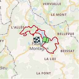
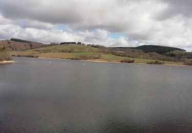
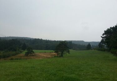
Trail Walking of 15.2 km to be discovered at New Aquitaine, Creuse, Faux-la-Montagne. This trail is proposed by viam19.

Description

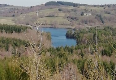
rando en boucle avec le tour du lac

Elevation profile

Photos

Positioning

Country:
France
Region :
New Aquitaine
Department/Province :
Creuse
Municipality :
Faux-la-Montagne
Location:
Unknown
Start:(UTM)
417273 ; 5066793 (31T) N.

Trails nearby

Trail Walking Peyrelevade - Fred lac du Chammet  - Photo
Walking
arnoultjf

Walking

Medium
Peyrelevade, New Aquitaine, Corrèze, France
6.7 km | 8.7 km-effort
1h 52min
Yes
Trail Walking Gentioux-Pigerolles - Gentilhomme pigerolles  - Photo
Walking
Alainschost

Walking

Gentioux-Pigerolles, New Aquitaine, Creuse, France
12.8 km | 17.2 km-effort
4h 1min
Yes
Trail Mountain bike Gentioux-Pigerolles - Circuit au Nord Est de Gentioux-Pigerolles - Photo
Mountain bike
tracegps

Mountain bike

Medium
Gentioux-Pigerolles, New Aquitaine, Creuse, France
17 km | 22 km-effort
2h 0min
Yes
Trail Walking Gentioux-Pigerolles - Circuit au Nord Est de Gentioux-Pigerolles - Photo
Walking
tracegps

Walking

Medium
Gentioux-Pigerolles, New Aquitaine, Creuse, France
17 km | 22 km-effort
6h 0min
Yes
Trail Mountain bike Royère-de-Vassivière - Lac de Vassivière - Vauveix - Photo
Mountain bike
tracegps

Mountain bike

Difficult
Royère-de-Vassivière, New Aquitaine, Creuse, France
35 km | 44 km-effort
3h 30min
No
Trail Mountain bike Royère-de-Vassivière - Le lac de Vassivière - Faux - Gentioux - Photo
Mountain bike
tracegps

Mountain bike

Difficult
Royère-de-Vassivière, New Aquitaine, Creuse, France
56 km | 70 km-effort
5h 0min
Yes
Trail Walking Faux-la-Montagne - Faux la montagne - Le Chammet  - Photo
Walking
Gegetop

Walking

Medium
Faux-la-Montagne, New Aquitaine, Creuse, France
15.8 km | 19.6 km-effort
4h 8min
Yes
Trail Walking Peyrelevade - Fred lac du chamet - Photo
Walking
arnoultjf

Walking

Very easy
Peyrelevade, New Aquitaine, Corrèze, France
8.7 km | 10 km-effort
2h 56min
Yes
Trail Walking Royère-de-Vassivière - tombe des officiers  - Photo
Walking
JoelHerve

Walking

Very easy
Royère-de-Vassivière, New Aquitaine, Creuse, France
16 km | 20 km-effort
5h 22min
Yes


Close
My subscriptions