Trail Walking Grandvillars - Circuit de Grandvillars - Photo
 tracegps
tracegps

User

© OpenStreetMap contributors
Length
Length
6.5 km
Max alt
Max alt
393 m
Uphill gradient
Uphill gradient
82 m
Km-Effort
Km-Effort  
7.6 km
Min alt
Min alt
343 m
Downhill gradient
Downhill gradient
82 m
Boucle
Boucle
Yes
Creation date :
2014-12-10 00:00:00.0
Updated on :
2014-12-10 00:00:00.0

(1 Reviews)

Walking
Walking
1h34
Difficulty : Easy

Scan this QR Code to open this trail in the SityTrail application

FREE GPS app for hiking

Logo SityTrail SityTrail

IGN / Geographical institutes

Download SityTrail from the App Store Download SityTrail from Google Play

Logo SityTrail SityTrail World

The world is yours!

Download SityTrail from the App Store Download SityTrail from Google Play Download SityTrail on Huawei AppGallery

About

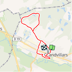
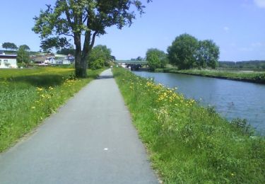
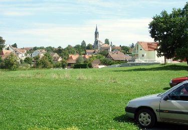
Trail Walking of 6.5 km to be discovered at Bourgogne-Franche-Comté, Territoire-de-Belfort, Grandvillars. This trail is proposed by tracegps.

Description

Circuit proposé par la Communauté de Communes du Sud Territoire et la Commune de Grandvillars. Départ de la place du 18 novembre, face au cimetière de Grandvillars. Retrouvez ce circuit sur le site de la Communauté de Communes du Sud Territoire.

Elevation profile

Photos

Positioning

Country:
France
Region :
Bourgogne-Franche-Comté
Department/Province :
Territoire-de-Belfort
Municipality :
Grandvillars
Location:
Unknown
Start:(UTM)
347394 ; 5266994 (32T) N.

Comments

Please log in to post a review or rate the element


Trails nearby

Trail Walking Boron - Balade de Normanvillars - Boron - Photo
Walking
tracegps

Walking

Medium
(4)
Boron, Bourgogne-Franche-Comté, Territoire-de-Belfort, France
11.3 km | 12.9 km-effort
3h 0min
Yes
Trail Walking Fêche-l'Église - balade - Photo
Walking
GUIDE
David25400

Walking

Very easy
Fêche-l'Église, Bourgogne-Franche-Comté, Territoire-de-Belfort, France
7.5 km | 8.8 km-effort
2h 44min
No
Trail Walking Méziré - champi feches - Photo
Walking
GUIDE
David25400

Walking

Very easy
Méziré, Bourgogne-Franche-Comté, Territoire-de-Belfort, France
3.2 km | 3.8 km-effort
1h 49min
Yes
Trail Mountain bike Dampierre-les-Bois - VTT Territoire et Doubs - Dampierre-les-Bois  - Photo
Mountain bike
tracegps

Mountain bike

Difficult
(1)
Dampierre-les-Bois, Bourgogne-Franche-Comté, Doubs, France
41 km | 48 km-effort
3h 15min
Yes
Trail Walking Faverois - Circuit de Faverois - Photo
Walking
tracegps

Walking

Medium
Faverois, Bourgogne-Franche-Comté, Territoire-de-Belfort, France
8.4 km | 9.7 km-effort
2h 4min
Yes
Trail Cycle Delle - Découverte de la route de la carpe frite - Delle - Photo
Cycle
tracegps

Cycle

Difficult
Delle, Bourgogne-Franche-Comté, Territoire-de-Belfort, France
50 km | 58 km-effort
3h 30min
Yes
Trail Walking Méziré - balade - Photo
Walking
GUIDE
David25400

Walking

Very easy
Méziré, Bourgogne-Franche-Comté, Territoire-de-Belfort, France
3.2 km | 3.9 km-effort
2h 14min
Yes
Trail Walking Méziré - Fesches_le_Chatel 181020 AM - Photo
Walking
GUIDE
David25400

Walking

Very easy
Méziré, Bourgogne-Franche-Comté, Territoire-de-Belfort, France
15.6 km | 19.5 km-effort
3h 12min
No
Trail Walking Bourogne - Bourogne Froidefontaine - Photo
Walking
Papamoju

Walking

Very easy
Bourogne, Bourgogne-Franche-Comté, Territoire-de-Belfort, France
6.4 km | 6.9 km-effort
1h 39min
Yes


Close
My subscriptions