Trail Mountain bike Volvic - La Tatave 2012 - Photo
© OpenStreetMap contributors
Length
Length
49 km
Max alt
Max alt
1192 m
Uphill gradient
Uphill gradient
1352 m
Km-Effort
Km-Effort  
67 km
Min alt
Min alt
583 m
Downhill gradient
Downhill gradient
1353 m
Boucle
Boucle
Yes
Creation date :
2014-12-10 00:00:00.0
Updated on :
2014-12-10 00:00:00.0

(0 Reviews)

Mountain bike
Mountain bike
--
Difficulty : Difficult

Scan this QR Code to open this trail in the SityTrail application

FREE GPS app for hiking

Logo SityTrail SityTrail

IGN / Geographical institutes

Download SityTrail from the App Store Download SityTrail from Google Play

Logo SityTrail SityTrail World

The world is yours!

Download SityTrail from the App Store Download SityTrail from Google Play Download SityTrail on Huawei AppGallery

About

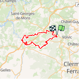
Trail Mountain bike of 49 km to be discovered at Auvergne-Rhône-Alpes, Puy-de-Dôme, Volvic. This trail is proposed by b00002473.

Description

Parcours 50 km VTT la Tatave 2012

Elevation profile

Positioning

Country:
France
Region :
Auvergne-Rhône-Alpes
Department/Province :
Puy-de-Dôme
Municipality :
Volvic
Location:
Unknown
Start:(UTM)
499461 ; 5080504 (31T) N.

Trails nearby

Trail On foot Loubeyrat - La Vallee des Prades - Photo
On foot
PRO

On foot

Easy
(1)
Loubeyrat, Auvergne-Rhône-Alpes, Puy-de-Dôme, France
11.1 km | 15.6 km-effort
3h 33min
Yes
Trail Walking Enval - Enval_Gorges - Photo
Walking
GUIDE
jagarnier

Walking

Medium
(1)
Enval, Auvergne-Rhône-Alpes, Puy-de-Dôme, France
9.1 km | 13.2 km-effort
2h 45min
Yes
Trail Walking Châtel-Guyon - Chazeron sans souci - Photo
Walking
Gegetop

Walking

Easy
(1)
Châtel-Guyon, Auvergne-Rhône-Alpes, Puy-de-Dôme, France
6.6 km | 9.7 km-effort
1h 45min
Yes
Trail Walking Châtel-Guyon - Boucle de Rochepradière en passant par Douhady - Photo
Walking
Gegetop

Walking

Easy
(1)
Châtel-Guyon, Auvergne-Rhône-Alpes, Puy-de-Dôme, France
6.7 km | 9.7 km-effort
2h 6min
Yes
Trail Mountain bike Volvic - Tour du Puy de Dôme en VTT - Photo
Mountain bike
tracegps

Mountain bike

Very difficult
(1)
Volvic, Auvergne-Rhône-Alpes, Puy-de-Dôme, France
62 km | 85 km-effort
5h 30min
Yes
Trail Nordic walking Saint-Ours - La louchadiere - Photo
Nordic walking
Gegetop

Nordic walking

Difficult
(1)
Saint-Ours, Auvergne-Rhône-Alpes, Puy-de-Dôme, France
11 km | 16.2 km-effort
2h 48min
Yes
Trail Walking Volvic - Les sources de Volvic - Photo
Walking
tracegps

Walking

Medium
(2)
Volvic, Auvergne-Rhône-Alpes, Puy-de-Dôme, France
10.9 km | 14.3 km-effort
3h 0min
Yes
Trail Walking Saint-Ours - Les Puys de Jumes et la Coquille par Beauregard - Photo
Walking
tracegps

Walking

Difficult
(2)
Saint-Ours, Auvergne-Rhône-Alpes, Puy-de-Dôme, France
8.6 km | 12.1 km-effort
3h 0min
Yes
Trail Walking Volvic - Egaules (près de Luzet) - Photo
Walking
tracegps

Walking

Difficult
(1)
Volvic, Auvergne-Rhône-Alpes, Puy-de-Dôme, France
8.8 km | 10.8 km-effort
2h 45min
Yes


Close
My subscriptions