Trail Winter sports Haut-Intyamon - Montbovon - Cuvignes - Prés d''Albeuve - Photo

Montbovon - Cuvignes - Prés d''Albeuve

© OpenStreetMap contributors
Length
Length
22 km
Max alt
Max alt
1332 m
Uphill gradient
Uphill gradient
891 m
Km-Effort
Km-Effort  
34 km
Min alt
Min alt
777 m
Downhill gradient
Downhill gradient
891 m
Boucle
Boucle
Yes
Creation date :
2014-12-11 00:00:00.0
Updated on :
2014-12-11 00:00:00.0

(0 Reviews)

Winter sports
Winter sports
--
Difficulty : Unknown

Scan this QR Code to open this trail in the SityTrail application

FREE GPS app for hiking

Logo SityTrail SityTrail

IGN / Geographical institutes

Download SityTrail from the App Store Download SityTrail from Google Play

Logo SityTrail SityTrail World

The world is yours!

Download SityTrail from the App Store Download SityTrail from Google Play Download SityTrail on Huawei AppGallery

About

Trail Winter sports of 22 km to be discovered at Fribourg, Gruyère District. This trail is proposed by vttnature.
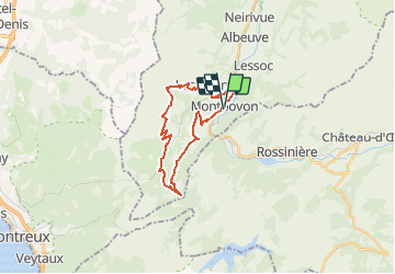
Description

Longueur : 27 Km
Déniveléé positive : 960 m

Topo : Départ du stade de Bouleyres. A l''entrée de la forêt, prendre à droite. Longer la Trême et rejoindre Broc par la forêt. A la sortie du village, prendre à droite la direction Motélon. Arrivé au ruisseau, le suivre jusqu''à la Pinte du Pralet. 200 m après, prendre à droite le chemin de montagne. Grimpée de 4 Km jusqu''au chalet Le Coulat. Portage jusqu''au col. Descendre le pâturage jusqu''à la route revêtue. Après 1 Km sur celle-ci, prendre à droite l''ancien chemin. Descendre jusqu''au village d''Estavennens. Continuer et avant le pont sur la Sarine, prendre à droite et longer la rivière jusqu''à Broc. Revenir à Bulle par la forêt.

Elevation profile

Positioning

Country:
Switzerland
Region :
Fribourg
Department/Province :
Gruyère District
Municipality :
Haut-Intyamon
Location:
Unknown
Start:(UTM)
349845 ; 5149901 (32T) N.

Trails nearby

Trail Cycle Rossinière - Rossinière - Vevey - Photo
Cycle
karawatsj

Cycle

Very difficult
Rossinière, Vaud, District de la Riviera-Pays-d’Enhaut, Switzerland
88 km | 115 km-effort
5h 56min
No
Trail Walking Haut-Intyamon - st_test3 - Photo
Walking
GUIDE+

Walking

Very easy
Haut-Intyamon, Fribourg, Gruyère District, Switzerland
7.5 km | 11 km-effort
2h 34min
No
Trail Walking Haut-Intyamon - Comba d’Avau – Montbovon - Photo
Walking
gpiller

Walking

Medium
Haut-Intyamon, Fribourg, Gruyère District, Switzerland
8.1 km | 12 km-effort
2h 30min
Yes
Trail Snowshoes  - Albeuve-Les Avants - Photo
Snowshoes
lroux

Snowshoes

Very easy
, Fribourg, Gruyère District, Switzerland
18.9 km | 35 km-effort
Unknown
No
Trail Walking Châtel-Saint-Denis - tour du Vuipey - Photo
Walking
jbrichard

Walking

Very easy
Châtel-Saint-Denis, Fribourg, District de la Veveyse, Switzerland
3.7 km | 7.2 km-effort
Unknown
No
Trail Other activity  - RAF 2008 - Photo
Other activity
pierrepraz

Other activity

Very easy
, Fribourg, Gruyère District, Switzerland
5 km | 9.5 km-effort
Unknown
No
Trail Other activity  - Les Cases - Jaman - Photo
Other activity
pierrepraz

Other activity

Very easy
, Fribourg, Gruyère District, Switzerland
3.4 km | 7.3 km-effort
Unknown
No
Trail Other activity Châtel-Saint-Denis - Dent de Lys - Photo
Other activity
daniel

Other activity

Very easy
Châtel-Saint-Denis, Fribourg, District de la Veveyse, Switzerland
4 km | 10 km-effort
2h 59min
No
Trail Other activity  - FR - Dent de Lys, Montbovon - Photo
Other activity
sterrettaz

Other activity

Very easy
, Fribourg, Gruyère District, Switzerland
4.2 km | 14 km-effort
Unknown
No


Close
My subscriptions