Trail Other activity Montreux - SCA-02-B-Les Avants - col de Jaman - Photo
 Dgubler
Dgubler

User

© OpenStreetMap contributors
Length
Length
3.6 km
Max alt
Max alt
1513 m
Uphill gradient
Uphill gradient
560 m
Km-Effort
Km-Effort  
9.3 km
Min alt
Min alt
973 m
Downhill gradient
Downhill gradient
22 m
Boucle
Boucle
No
Creation date :
2014-12-11 00:00:00.0
Updated on :
2014-12-11 00:00:00.0

(0 Reviews)

Other activity
Other activity
--
Difficulty : Unknown

Scan this QR Code to open this trail in the SityTrail application

FREE GPS app for hiking

Logo SityTrail SityTrail

IGN / Geographical institutes

Download SityTrail from the App Store Download SityTrail from Google Play

Logo SityTrail SityTrail World

The world is yours!

Download SityTrail from the App Store Download SityTrail from Google Play Download SityTrail on Huawei AppGallery

About

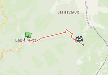
Trail Other activity of 3.6 km to be discovered at Vaud, District de la Riviera-Pays-d’Enhaut, Montreux. This trail is proposed by Dgubler.

Description

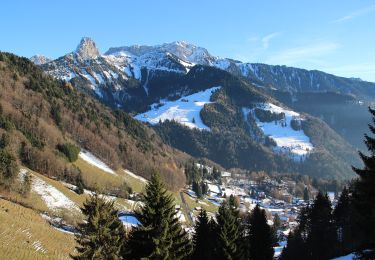
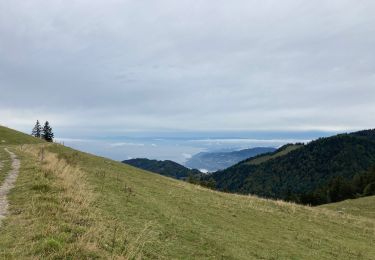
Nous avons fait cette randonnée le 16 octobre 2003 (Axel n''avait pas encore 5 ans !) par une magnifique journée d''automne : le col par mer de brouillard vaut vraiment le voyage !

If, like us on 16 October 2003, you hike on a beautiful autumn day, you might see the "cloud see" covered Lake Geneva.

Elevation profile

Positioning

Country:
Switzerland
Region :
Vaud
Department/Province :
District de la Riviera-Pays-d’Enhaut
Municipality :
Montreux
Location:
Unknown
Start:(UTM)
342021 ; 5146458 (32T) N.

Trails nearby

Trail Walking Montreux - Montreux - Villeneuve - Le Bouveret - Photo
Walking
GUIDE+

Walking

Very easy
(1)
Montreux, Vaud, District de la Riviera-Pays-d’Enhaut, Switzerland
14.5 km | 16.4 km-effort
Unknown
No
Trail On foot Montreux - Sentier des Narcisses - Photo
On foot
PRO

On foot

Easy
Montreux, Vaud, District de la Riviera-Pays-d’Enhaut, Switzerland
5.4 km | 9.8 km-effort
2h 13min
Yes
Trail Walking Montreux - Le PACCOTA  - Photo
Walking
GioA10

Walking

Easy
Montreux, Vaud, District de la Riviera-Pays-d’Enhaut, Switzerland
5 km | 7.2 km-effort
1h 54min
Yes
Trail Walking Veytaux - st_Rochers-de-Naye - Photo
Walking
GUIDE+

Walking

Very easy
Veytaux, Vaud, District de la Riviera-Pays-d’Enhaut, Switzerland
6.4 km | 11.1 km-effort
1h 42min
No
Trail Mountain bike Blonay - Les Pléiades - Photo
Mountain bike
GUIDE+

Mountain bike

Very easy
Blonay, Vaud, District de la Riviera-Pays-d’Enhaut, Switzerland
35 km | 44 km-effort
11h 26min
No
Trail Walking Montreux - Dent de Jaman - Rochers - de Naye - Photo
Walking
GUIDE+

Walking

Very easy
(1)
Montreux, Vaud, District de la Riviera-Pays-d’Enhaut, Switzerland
3.4 km | 6.6 km-effort
Unknown
No
Trail On foot Montreux - Les Gorges du Chauderon - Photo
On foot
famiski

On foot

Easy
Montreux, Vaud, District de la Riviera-Pays-d’Enhaut, Switzerland
6.7 km | 11.8 km-effort
2h 40min
Yes
Trail On foot Montreux - Itinéraire course à pied : Boucle Hauts-de-Caux - Sonchaux - Photo
On foot
famiski

On foot

Easy
Montreux, Vaud, District de la Riviera-Pays-d’Enhaut, Switzerland
9.8 km | 15.4 km-effort
3h 30min
Yes
Trail Running Montreux - Itinéraire course à pied : Tour du Cubly - Photo
Running
famiski

Running

Medium
Montreux, Vaud, District de la Riviera-Pays-d’Enhaut, Switzerland
5.5 km | 9.9 km-effort
35min
Yes


Close
My subscriptions