Trail Other activity Montreux - SCA-02-C-Col de Jaman - Montbovon - Photo
 Dgubler
Dgubler

User

© OpenStreetMap contributors
Length
Length
8.9 km
Max alt
Max alt
1511 m
Uphill gradient
Uphill gradient
146 m
Km-Effort
Km-Effort  
13.2 km
Min alt
Min alt
797 m
Downhill gradient
Downhill gradient
856 m
Boucle
Boucle
No
Creation date :
2014-12-11 00:00:00.0
Updated on :
2014-12-11 00:00:00.0

(0 Reviews)

Other activity
Other activity
--
Difficulty : Unknown

Scan this QR Code to open this trail in the SityTrail application

FREE GPS app for hiking

Logo SityTrail SityTrail

IGN / Geographical institutes

Download SityTrail from the App Store Download SityTrail from Google Play

Logo SityTrail SityTrail World

The world is yours!

Download SityTrail from the App Store Download SityTrail from Google Play Download SityTrail on Huawei AppGallery

About

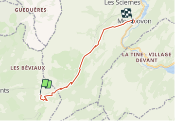
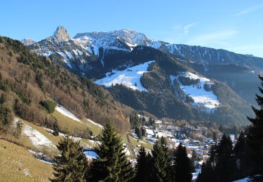
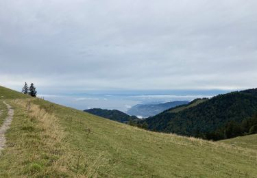
Trail Other activity of 8.9 km to be discovered at Vaud, District de la Riviera-Pays-d’Enhaut, Montreux. This trail is proposed by Dgubler.

Description

Dans le sens indiqué, ça descend ! Nous l''avons fait en famille le 16 octobre 2003, jusqu''à la halte des Cases où on peut reprendre le train pour Les Avants et Montreux. Le sentier est fléché "Sentier historique n°2". Voir aussi www.montbovon.ch.

A downhill hike, of which we did the first part on 16 October 2003.

Elevation profile

Positioning

Country:
Switzerland
Region :
Vaud
Department/Province :
District de la Riviera-Pays-d’Enhaut
Municipality :
Montreux
Location:
Unknown
Start:(UTM)
344646 ; 5146222 (32T) N.

Trails nearby

Trail On foot Montreux - Sentier des Narcisses - Photo
On foot
PRO

On foot

Easy
Montreux, Vaud, District de la Riviera-Pays-d’Enhaut, Switzerland
5.4 km | 9.8 km-effort
2h 13min
Yes
Trail Walking Montreux - Le PACCOTA  - Photo
Walking
GioA10

Walking

Easy
Montreux, Vaud, District de la Riviera-Pays-d’Enhaut, Switzerland
5 km | 7.2 km-effort
1h 54min
Yes
Trail Walking Veytaux - st_Rochers-de-Naye - Photo
Walking
GUIDE+

Walking

Very easy
Veytaux, Vaud, District de la Riviera-Pays-d’Enhaut, Switzerland
6.4 km | 11.1 km-effort
1h 42min
No
Trail Walking Montreux - Dent de Jaman - Rochers - de Naye - Photo
Walking
GUIDE+

Walking

Very easy
(1)
Montreux, Vaud, District de la Riviera-Pays-d’Enhaut, Switzerland
3.4 km | 6.6 km-effort
Unknown
No
Trail On foot Montreux - Itinéraire course à pied : Boucle Hauts-de-Caux - Sonchaux - Photo
On foot
famiski

On foot

Easy
Montreux, Vaud, District de la Riviera-Pays-d’Enhaut, Switzerland
9.8 km | 15.4 km-effort
3h 30min
Yes
Trail Running Montreux - Itinéraire course à pied : Tour du Cubly - Photo
Running
famiski

Running

Medium
Montreux, Vaud, District de la Riviera-Pays-d’Enhaut, Switzerland
5.5 km | 9.9 km-effort
35min
Yes
Trail Walking Montreux - train  Montreux - Photo
Walking
aubr

Walking

Difficult
Montreux, Vaud, District de la Riviera-Pays-d’Enhaut, Switzerland
9.2 km | 14.2 km-effort
39min
No
Trail Walking Montreux - Les Avants - Photo
Walking
henriclement

Walking

Easy
Montreux, Vaud, District de la Riviera-Pays-d’Enhaut, Switzerland
5.1 km | 7.5 km-effort
2h 31min
No
Trail Running Montreux - Montreux rocher de Naye - Photo
Running
Albust

Running

Difficult
Montreux, Vaud, District de la Riviera-Pays-d’Enhaut, Switzerland
25 km | 49 km-effort
8h 57min
No


Close
My subscriptions