Trail Walking Gex - GEX  : le tour du Creux de l''Envers - Photo

GEX : le tour du Creux de l''Envers

 otgex
otgex

User

© OpenStreetMap contributors
Length
Length
6.5 km
Max alt
Max alt
754 m
Uphill gradient
Uphill gradient
197 m
Km-Effort
Km-Effort  
9.1 km
Min alt
Min alt
594 m
Downhill gradient
Downhill gradient
192 m
Boucle
Boucle
Yes
Creation date :
2014-12-11 00:00:00.0
Updated on :
2014-12-11 00:00:00.0

(0 Reviews)

Walking
Walking
2h00
Difficulty : Unknown

Scan this QR Code to open this trail in the SityTrail application

FREE GPS app for hiking

Logo SityTrail SityTrail

IGN / Geographical institutes

Download SityTrail from the App Store Download SityTrail from Google Play

Logo SityTrail SityTrail World

The world is yours!

Download SityTrail from the App Store Download SityTrail from Google Play Download SityTrail on Huawei AppGallery

About

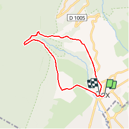
Trail Walking of 6.5 km to be discovered at Auvergne-Rhône-Alpes, Ain, Gex. This trail is proposed by otgex.

Description

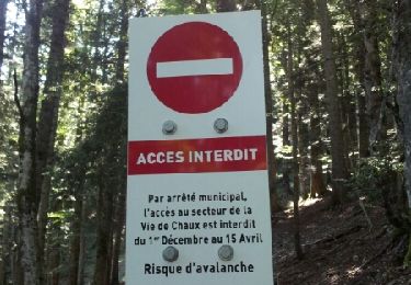
Au départ de l''Office de Tourisme (chalet d''accueil au rond point du Patio à Gex), prendre la direction St Genis-Pouilly/centre ville (1) ; au carrefour (intersection route de Lyon/rue du commerce/rue de Genève), prendre la rue "Léone de Joinville (2), passez le pont du Journans et commencez la montée en direction du Jura.

Toujours en montant, à la 2ème patte d''oie, prendre à droite le chemin des "Galas" (3) sur environ 300 mètres ; au croisement, à droite, vous empruntez la route forestière du Creux de l''Envers (4).

Vous arrivez sur une grande place (5); continuez ensuite tout droit le chemin caillouteux descendant légèrement sur 500 mètres. Au virage (6), tournez à droite, passez devant un abri forestier puis le pont. Restez sur la route principale au croisement suivant.

Passez devant le bâtiment de la colonie "la Noyelle" (volets rouges) (7). Poursuivez toujours cette route (route de la Noyelle), puis prenez la route de Rogeland (8), vous arrivez place Perdtemps; descendez la route pour passer devant l''église puis la mairie. Descendez la rue des terreaux et tournez à gauche en bas de la rue pour revenir devant le chalet de l''Office de Tourisme.

Elevation profile

Points of interest

Point of interest Gex - église  - Photo
otgex
Point of interest Gex - 7) - Photo
otgex
GEX 
Point of interest Gex - 5) - Photo
otgex
GEX 
Point of interest Gex - O.T. - Photo
otgex
GEX 

Positioning

Country:
France
Region :
Auvergne-Rhône-Alpes
Department/Province :
Ain
Municipality :
Gex
Location:
Unknown
Start:(UTM)
273688 ; 5135162 (32T) N.

Trails nearby

Trail Running Mijoux - UTTJ 2015-2 - Photo
Running
bourel.jacques

Running

Very difficult
(1)
Mijoux, Auvergne-Rhône-Alpes, Ain, France
57 km | 92 km-effort
18h 13min
No
Trail Walking Gex - Balade à Col de la Faucille, Gex - Photo
Walking
Gaiato

Walking

Very difficult
Gex, Auvergne-Rhône-Alpes, Ain, France
86 km | 135 km-effort
9h 23min
No
Trail Bicycle tourism Mijoux - LES ROUSSES - COL DE LA FAUCILLE  - Photo
Bicycle tourism
jean-marie.parachini

Bicycle tourism

Very difficult
Mijoux, Auvergne-Rhône-Alpes, Ain, France
54 km | 68 km-effort
4h 57min
No
Trail Walking Gex - la faucille - montrond - Photo
Walking
thierrytm

Walking

Medium
Gex, Auvergne-Rhône-Alpes, Ain, France
12.4 km | 22 km-effort
1h 35min
No
Trail Walking Mijoux - GR 9 Étape 8 - Mijoux - Refuge de la Loge - Photo
Walking
pcugnod

Walking

Difficult
Mijoux, Auvergne-Rhône-Alpes, Ain, France
14.9 km | 24 km-effort
5h 37min
No
Trail Snowshoes Mijoux - MTROND 2019 - Photo
Snowshoes
UDGI54

Snowshoes

Difficult
(1)
Mijoux, Auvergne-Rhône-Alpes, Ain, France
9.2 km | 14.1 km-effort
2h 55min
No
Trail Walking Mijoux - Mijoux_Colomby de Gex D+ 1523 21.6 km 20150825 - Photo
Walking
cmike39

Walking

Very easy
Mijoux, Auvergne-Rhône-Alpes, Ain, France
22 km | 38 km-effort
8h 22min
No
Trail Walking Échenevex - Sources de l''Allondon - Echenevex - Photo
Walking
tracegps

Walking

Medium
Échenevex, Auvergne-Rhône-Alpes, Ain, France
3.5 km | 4.4 km-effort
2h 0min
Yes
Trail Walking Gex - Le colomby de gex - Photo
Walking
tippex01

Walking

Difficult
(1)
Gex, Auvergne-Rhône-Alpes, Ain, France
14 km | 24 km-effort
4h 30min
Yes


Close
My subscriptions