Trail Walking Gex - GEX - VESANCY : en passant par la campagne - Photo

GEX - VESANCY : en passant par la campagne

 otgex
otgex

User

© OpenStreetMap contributors
Length
Length
8.8 km
Max alt
Max alt
770 m
Uphill gradient
Uphill gradient
217 m
Km-Effort
Km-Effort  
11.7 km
Min alt
Min alt
598 m
Downhill gradient
Downhill gradient
215 m
Boucle
Boucle
Yes
Creation date :
2014-12-11 00:00:00.0
Updated on :
2014-12-11 00:00:00.0

(0 Reviews)

Walking
Walking
2h30
Difficulty : Unknown

Scan this QR Code to open this trail in the SityTrail application

FREE GPS app for hiking

Logo SityTrail SityTrail

IGN / Geographical institutes

Download SityTrail from the App Store Download SityTrail from Google Play

Logo SityTrail SityTrail World

The world is yours!

Download SityTrail from the App Store Download SityTrail from Google Play Download SityTrail on Huawei AppGallery

About

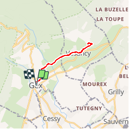
Trail Walking of 8.8 km to be discovered at Auvergne-Rhône-Alpes, Ain, Gex. This trail is proposed by otgex.

Description

Au départ de l''Office de Tourisme (chalet d''accueil à Gex), prenez à droite, direction la Poste. Puis aux feux, prenez à nouveau à droite : rue de Gex-La Ville.
Après environ 1 km, prenez la route perpendiculaire sur votre gauche (face au Jura) : la rue des Usiniers (1). Remontez la jusqu''au prochain carrefour (une ancienne ferme gessienne fait l''angle).
Prenez alors à droite (rue de la Forêt de Disse) sur environ 500 mètres (2). Au virage, suivez le panneau rando "Paroset 625 mètres d''altitude" (3).
Suivez la direction "Gex-Vesancy" et prenez le chemin carrossable en sous-bois. Suivez ce chemin sur environ 1 km. Vous retrouvez ensuite la route goudronnée. Arrivé à la patte d''oie, prenez tout droit la route de Bottenay (4) qui monte. Vous entrez dans le village de Vesancy. Continuez sur 500 mètres et  remontez la rue du Château (5). A la patte d''oie, prenez la route de la Chapelle jusqu''au croisement à la Croix (6). Ici s''arrête la balade simple pour Vesancy.

Variante : vous pouvez prolonger par la petite route goudronnée qui monte sur environ 700 mètres (7) pour aller jusqu''à la Chapelle de Riantmont. Arrivé au parking, prenez le chemin caillouteux et passez la clotûre. Découvrez alors la magnifique chapelle de Riantmont.
Pour revenir au village, reprenez la même route jusqu''au village puis jusqu''à Gex.

Elevation profile

Points of interest

Point of interest Vesancy - 5) château - Photo
otgex
VESANCY 
Point of interest Gex - Départ - Photo
otgex
GEX 
Point of interest Vesancy - 4) Rte de Bottenay - Photo
otgex

Positioning

Country:
France
Region :
Auvergne-Rhône-Alpes
Department/Province :
Ain
Municipality :
Gex
Location:
Unknown
Start:(UTM)
273690 ; 5135164 (32T) N.

Trails nearby

Trail Running Mijoux - UTTJ 2015-2 - Photo
Running
bourel.jacques

Running

Very difficult
(1)
Mijoux, Auvergne-Rhône-Alpes, Ain, France
57 km | 92 km-effort
18h 13min
No
Trail Walking Gex - Balade à Col de la Faucille, Gex - Photo
Walking
Gaiato

Walking

Very difficult
Gex, Auvergne-Rhône-Alpes, Ain, France
86 km | 135 km-effort
9h 23min
No
Trail Bicycle tourism Mijoux - LES ROUSSES - COL DE LA FAUCILLE  - Photo
Bicycle tourism
jean-marie.parachini

Bicycle tourism

Very difficult
Mijoux, Auvergne-Rhône-Alpes, Ain, France
54 km | 68 km-effort
4h 57min
No
Trail Walking Gex - la faucille - montrond - Photo
Walking
thierrytm

Walking

Medium
Gex, Auvergne-Rhône-Alpes, Ain, France
12.4 km | 22 km-effort
1h 35min
No
Trail Walking Mijoux - GR 9 Étape 8 - Mijoux - Refuge de la Loge - Photo
Walking
pcugnod

Walking

Difficult
Mijoux, Auvergne-Rhône-Alpes, Ain, France
14.9 km | 24 km-effort
5h 37min
No
Trail Snowshoes Mijoux - MTROND 2019 - Photo
Snowshoes
UDGI54

Snowshoes

Difficult
(1)
Mijoux, Auvergne-Rhône-Alpes, Ain, France
9.2 km | 14.1 km-effort
2h 55min
No
Trail Walking Mijoux - Mijoux_Colomby de Gex D+ 1523 21.6 km 20150825 - Photo
Walking
cmike39

Walking

Very easy
Mijoux, Auvergne-Rhône-Alpes, Ain, France
22 km | 38 km-effort
8h 22min
No
Trail Walking Échenevex - Sources de l''Allondon - Echenevex - Photo
Walking
tracegps

Walking

Medium
Échenevex, Auvergne-Rhône-Alpes, Ain, France
3.5 km | 4.4 km-effort
2h 0min
Yes
Trail Walking Gex - Le colomby de gex - Photo
Walking
tippex01

Walking

Difficult
(1)
Gex, Auvergne-Rhône-Alpes, Ain, France
14 km | 24 km-effort
4h 30min
Yes


Close
My subscriptions