Trail Walking Volvic - Les Goulots-Lambertèche  - Photo

Les Goulots-Lambertèche

 Gegetop
Gegetop

User

© OpenStreetMap contributors
Length
Length
12.1 km
Max alt
Max alt
897 m
Uphill gradient
Uphill gradient
223 m
Km-Effort
Km-Effort  
15 km
Min alt
Min alt
775 m
Downhill gradient
Downhill gradient
222 m
Boucle
Boucle
Yes
Creation date :
2015-07-16 00:00:00.0
Updated on :
2015-07-16 00:00:00.0

(1 Reviews)

Walking
Walking
2h37
Difficulty : Easy

Scan this QR Code to open this trail in the SityTrail application

FREE GPS app for hiking

Logo SityTrail SityTrail

IGN / Geographical institutes

Download SityTrail from the App Store Download SityTrail from Google Play

Logo SityTrail SityTrail World

The world is yours!

Download SityTrail from the App Store Download SityTrail from Google Play Download SityTrail on Huawei AppGallery

About

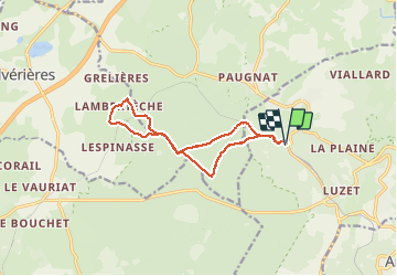
Trail Walking of 12.1 km to be discovered at Auvergne-Rhône-Alpes, Puy-de-Dôme, Volvic. This trail is proposed by Gegetop.

Elevation profile

Photos

Points of interest

Point of interest Pulvérières - Point 1 - Photo
Gegetop
PULVÉRIÈRES 
Point of interest Pulvérières - Point 2 - Photo
Gegetop
PULVÉRIÈRES 

Positioning

Country:
France
Region :
Auvergne-Rhône-Alpes
Department/Province :
Puy-de-Dôme
Municipality :
Volvic
Location:
Unknown
Start:(UTM)
499529 ; 5079714 (31T) N.

Comments

Please log in to post a review or rate the element


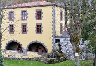
belle ballade en grande partie en forêt.


Trails nearby

Trail Walking Chanat-la-Mouteyre - Chanat_Trois_Villages - Photo
Walking
GUIDE
jagarnier

Walking

Medium
(1)
Chanat-la-Mouteyre, Auvergne-Rhône-Alpes, Puy-de-Dôme, France
10 km | 14 km-effort
3h 0min
Yes
Trail Walking Enval - Enval_Gorges - Photo
Walking
GUIDE
jagarnier

Walking

Medium
(1)
Enval, Auvergne-Rhône-Alpes, Puy-de-Dôme, France
9.1 km | 13.2 km-effort
2h 45min
Yes
Trail Walking Sayat - Sayat_Repaire_Gaulois - Photo
Walking
GUIDE
jagarnier

Walking

Easy
(1)
Sayat, Auvergne-Rhône-Alpes, Puy-de-Dôme, France
6.1 km | 9.3 km-effort
1h 59min
Yes
Trail Walking Châtel-Guyon - Boucle de Rochepradière en passant par Douhady - Photo
Walking
Gegetop

Walking

Easy
(1)
Châtel-Guyon, Auvergne-Rhône-Alpes, Puy-de-Dôme, France
6.7 km | 9.7 km-effort
2h 6min
Yes
Trail Mountain bike Volvic - Tour du Puy de Dôme en VTT - Photo
Mountain bike
tracegps

Mountain bike

Very difficult
(1)
Volvic, Auvergne-Rhône-Alpes, Puy-de-Dôme, France
62 km | 85 km-effort
5h 30min
Yes
Trail Nordic walking Saint-Ours - La louchadiere - Photo
Nordic walking
Gegetop

Nordic walking

Difficult
(1)
Saint-Ours, Auvergne-Rhône-Alpes, Puy-de-Dôme, France
11 km | 16.2 km-effort
2h 48min
Yes
Trail Walking Volvic - Les sources de Volvic - Photo
Walking
tracegps

Walking

Medium
(2)
Volvic, Auvergne-Rhône-Alpes, Puy-de-Dôme, France
10.9 km | 14.3 km-effort
3h 0min
Yes
Trail Walking Saint-Ours - Les Puys de Jumes et la Coquille par Beauregard - Photo
Walking
tracegps

Walking

Difficult
(2)
Saint-Ours, Auvergne-Rhône-Alpes, Puy-de-Dôme, France
8.6 km | 12.1 km-effort
3h 0min
Yes
Trail Walking Volvic - Egaules (près de Luzet) - Photo
Walking
tracegps

Walking

Difficult
(1)
Volvic, Auvergne-Rhône-Alpes, Puy-de-Dôme, France
8.8 km | 10.8 km-effort
2h 45min
Yes


Close
My subscriptions