Trail Walking Irun - Camino del Norte - Photo

Randonnées de l'Institut National Géographique

© OpenStreetMap contributors
Length
Length
815 km
Max alt
Max alt
713 m
Uphill gradient
Uphill gradient
17638 m
Km-Effort
Km-Effort  
1049 km
Min alt
Min alt
-6 m
Downhill gradient
Downhill gradient
17252 m
Boucle
Boucle
No
Creation date :
2015-09-01 00:00:00.0
Updated on :
2015-09-01 00:00:00.0

(0 Reviews)

Walking
Walking
8h53
Difficulty : Unknown

Scan this QR Code to open this trail in the SityTrail application

FREE GPS app for hiking

Logo SityTrail SityTrail

IGN / Geographical institutes

Download SityTrail from the App Store Download SityTrail from Google Play

Logo SityTrail SityTrail World

The world is yours!

Download SityTrail from the App Store Download SityTrail from Google Play Download SityTrail on Huawei AppGallery

About

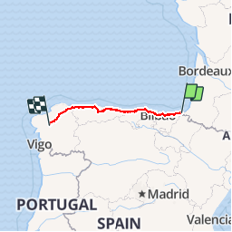
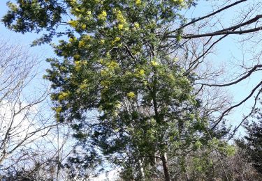
Trail Walking of 815 km to be discovered at Autonomous Community of the Basque Country, Gipuzkoa, Irun. This trail is proposed by Institut Géographique National.

Elevation profile

Positioning

Country:
Spain
Region :
Autonomous Community of the Basque Country
Department/Province :
Gipuzkoa
Municipality :
Irun
Location:
Unknown
Start:(UTM)
598437 ; 4800293 (30T) N.

Trails nearby

Trail Walking Biriatou - Biriatou et lac Poiriers - Photo
Walking
RVMASSON

Walking

Medium
(1)
Biriatou, New Aquitaine, Pyrénées-Atlantiques, France
10.1 km | 17.1 km-effort
3h 45min
Yes
Trail Walking Hondarribia/Fontarrabie - roro - Photo
Walking
chantal40

Walking

Very easy
(1)
Hondarribia/Fontarrabie, Autonomous Community of the Basque Country, Gipuzkoa, Spain
21 km | 31 km-effort
9h 10min
No
Trail Walking Hondarribia/Fontarrabie - Jaizkibel - Chemin côtier - Cap du Figuier - Notre-Dame de Guadalupe - Photo
Walking
georgein

Walking

Very easy
(3)
Hondarribia/Fontarrabie, Autonomous Community of the Basque Country, Gipuzkoa, Spain
13.7 km | 18.9 km-effort
3h 59min
Yes
Trail Walking Irun - Ibarla - Cascade d'Aitzondo - Ermitage san Martzial 2024 01 21 - Photo
Walking
DECHAMPD

Walking

Very difficult
Irun, Autonomous Community of the Basque Country, Gipuzkoa, Spain
12.1 km | 19.7 km-effort
4h 28min
Yes
Trail Walking Hondarribia/Fontarrabie - Pasaia les vallées des couleurs - Photo
Walking
ChristopheLefauconnier

Walking

Difficult
Hondarribia/Fontarrabie, Autonomous Community of the Basque Country, Gipuzkoa, Spain
11.9 km | 18 km-effort
4h 34min
Yes
Trail Walking Hondarribia/Fontarrabie - Fondarrabie sentier côtier bis  - Photo
Walking
GUIDE
antignacs

Walking

Easy
Hondarribia/Fontarrabie, Autonomous Community of the Basque Country, Gipuzkoa, Spain
13.1 km | 18 km-effort
3h 56min
Yes
Trail On foot Irun - SL-GI 1006 Cascada de Aitzondo - Photo
On foot
PRO

On foot

Easy
Irun, Autonomous Community of the Basque Country, Gipuzkoa, Spain
6 km | 8.4 km-effort
1h 54min
Yes
Trail Walking Hondarribia/Fontarrabie - hondarribia cap figuier - Photo
Walking
marchev

Walking

Medium
Hondarribia/Fontarrabie, Autonomous Community of the Basque Country, Gipuzkoa, Spain
15.1 km | 21 km-effort
5h 15min
Yes
Trail Walking Biriatou - biriatou chemin de la foret - Photo
Walking
brindacier

Walking

Easy
Biriatou, New Aquitaine, Pyrénées-Atlantiques, France
4 km | 6.4 km-effort
1h 21min
No


Close
My subscriptions