Trail Running Stavelot - Stavelot_9km - Photo
 florkin
florkin

User

© OpenStreetMap contributors
Length
Length
9.9 km
Max alt
Max alt
511 m
Uphill gradient
Uphill gradient
276 m
Km-Effort
Km-Effort  
13.6 km
Min alt
Min alt
281 m
Downhill gradient
Downhill gradient
274 m
Boucle
Boucle
Yes
Creation date :
2016-06-12 00:00:00.0
Updated on :
2016-06-12 00:00:00.0

(2 Reviews)

Running
Running
1h00
Difficulty : Easy

Scan this QR Code to open this trail in the SityTrail application

FREE GPS app for hiking

Logo SityTrail SityTrail

IGN / Geographical institutes

Download SityTrail from the App Store Download SityTrail from Google Play

Logo SityTrail SityTrail World

The world is yours!

Download SityTrail from the App Store Download SityTrail from Google Play Download SityTrail on Huawei AppGallery

About

Trail Running of 9.9 km to be discovered at Wallonia, Liège, Stavelot. This trail is proposed by florkin.

Elevation profile

Positioning

Country:
Belgium
Region :
Wallonia
Department/Province :
Liège
Municipality :
Stavelot
Location:
Stavelot
Start:(UTM)
708379 ; 5586514 (31U) N.

Comments

Please log in to post a review or rate the element


Mooie toch, maar wel veel ongelijke oppervlakte...maar dat was juist leuk. Helaas een paar stukken verhard. Verder goed aangegeven.


Trails nearby

Trail Walking Trois-Ponts - RB-Lg-29_Wanne - Photo
Walking
PRO

Walking

Very difficult
(5)
Trois-Ponts, Wallonia, Liège, Belgium
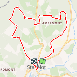
22 km | 29 km-effort
6h 9min
Yes
Trail Walking Trois-Ponts - RB-Lg-27_Trois-Ponts - Photo
Walking
PRO

Walking

Very difficult
(7)
Trois-Ponts, Wallonia, Liège, Belgium
23 km | 33 km-effort
6h 58min
Yes
Trail Walking Stavelot - 2021-06-30_12h14m27_stavelot_13km_new - Photo
Walking
GUIDE
mumu.larandonneuse

Walking

Medium
(2)
Stavelot, Wallonia, Liège, Belgium
13.4 km | 19.8 km-effort
4h 30min
Yes
Trail Walking Stavelot - 2021-03-10_14h59m08_1227 - Photo
Walking
GUIDE
mumu.larandonneuse

Walking

Difficult
(3)
Stavelot, Wallonia, Liège, Belgium
18.8 km | 26 km-effort
5h 53min
No
Trail Walking Trois-Ponts - RB-Lg-29_Wanne_via-racc-2 - Photo
Walking
PRO

Walking

Very difficult
(3)
Trois-Ponts, Wallonia, Liège, Belgium
14.2 km | 19.2 km-effort
4h 21min
Yes
Trail Walking Trois-Ponts - RB-Lg-27_Trois-Ponts_via-racc - Photo
Walking
PRO

Walking

Very difficult
(1)
Trois-Ponts, Wallonia, Liège, Belgium
17 km | 25 km-effort
5h 12min
Yes
Trail Walking Stavelot - Chemin des Sources |stage 3 STAVELOT - HOCKAI - Photo
Walking
PRO

Walking

Very difficult
(1)
Stavelot, Wallonia, Liège, Belgium
19 km | 25 km-effort
5h 45min
No
Trail Trail Stavelot - Extratrail - Stavelot (red) 23km - Photo
Trail
PRO

Trail

Very difficult
(1)
Stavelot, Wallonia, Liège, Belgium
23 km | 35 km-effort
Unknown
Yes
Trail Trail Stavelot - Extra Trail - Stavelot (blue) 13km - Photo
Trail
PRO

Trail

Difficult
(1)
Stavelot, Wallonia, Liège, Belgium
13.4 km | 19.5 km-effort
Unknown
Yes


Close
My subscriptions