Trail Walking Chamonix-Mont-Blanc - La cascade du dard - Photo
 pascalou73
pascalou73

User GUIDE

© OpenStreetMap contributors
Length
Length
8.2 km
Max alt
Max alt
1409 m
Uphill gradient
Uphill gradient
406 m
Km-Effort
Km-Effort  
13.6 km
Min alt
Min alt
1029 m
Downhill gradient
Downhill gradient
409 m
Boucle
Boucle
Yes
Creation date :
2016-09-05 00:00:00.0
Updated on :
2016-09-05 00:00:00.0

(0 Reviews)

Walking
Walking
2h00
Difficulty : Medium

Scan this QR Code to open this trail in the SityTrail application

FREE GPS app for hiking

Logo SityTrail SityTrail

IGN / Geographical institutes

Download SityTrail from the App Store Download SityTrail from Google Play

Logo SityTrail SityTrail World

The world is yours!

Download SityTrail from the App Store Download SityTrail from Google Play Download SityTrail on Huawei AppGallery

About

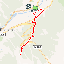
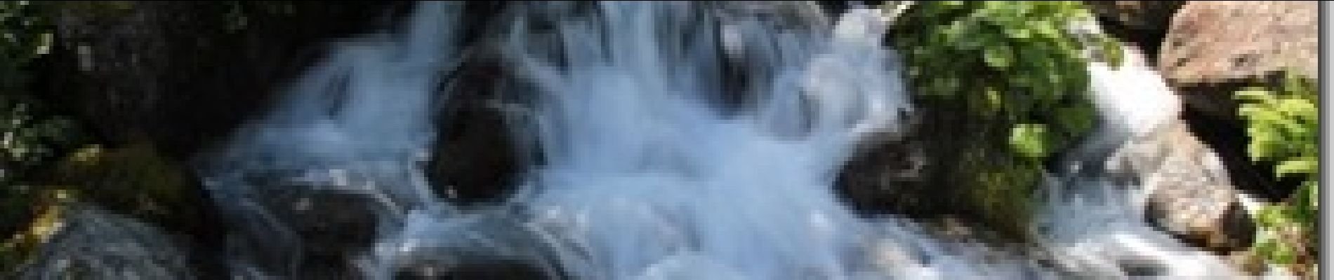
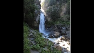
Trail Walking of 8.2 km to be discovered at Auvergne-Rhône-Alpes, Upper Savoy, Chamonix-Mont-Blanc. This trail is proposed by pascalou73.

Description

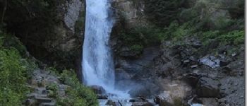
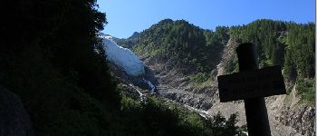
Au départ de chamonix vous pouvez aller voir une trés belle cascade avec un beau petit établissement et ensuite vous pouvez aller au point de vue sur le glacier des Bossons .

Elevation profile

Photos

Points of interest

Point of interest Dinant - 001 - Photo
pascalou73
DINANT 
Point of interest Chamonix-Mont-Blanc - chamonix - Photo
pascalou73
CHAMONIX-MONT-BLANC 
Point of interest Chamonix-Mont-Blanc - chamonix - Photo
pascalou73
CHAMONIX-MONT-BLANC 
Point of interest Chamonix-Mont-Blanc - chamonix - Photo
pascalou73
CHAMONIX-MONT-BLANC 
Point of interest Chamonix-Mont-Blanc - chamonix - Photo
pascalou73
CHAMONIX-MONT-BLANC 

Positioning

Country:
France
Region :
Auvergne-Rhône-Alpes
Department/Province :
Upper Savoy
Municipality :
Chamonix-Mont-Blanc
Location:
Unknown
Start:(UTM)
334160 ; 5086788 (32T) N.

Trails nearby

Trail Running Chamonix-Mont-Blanc - The North Face© Ultra Trail du Mont-Blanc© UTMB 2008 - Photo
Running
tracegps

Running

Very difficult
(2)
Chamonix-Mont-Blanc, Auvergne-Rhône-Alpes, Upper Savoy, France
160 km | 288 km-effort
46h 0min
Yes
Trail Walking Chamonix-Mont-Blanc - Circuit de la Mer de Glace - Chamonix Mont Blanc - Photo
Walking
tracegps

Walking

Difficult
(2)
Chamonix-Mont-Blanc, Auvergne-Rhône-Alpes, Upper Savoy, France
13.3 km | 24 km-effort
5h 30min
Yes
Trail Walking Chamonix-Mont-Blanc - Glacier des Bossons Les Houches Chamonix - Photo
Walking
tracegps

Walking

Difficult
(2)
Chamonix-Mont-Blanc, Auvergne-Rhône-Alpes, Upper Savoy, France
13.1 km | 28 km-effort
5h 0min
Yes
Trail Running Chamonix-Mont-Blanc - Hôtel Arveyron au Chalet de la Floria - Photo
Running
Albust

Running

Medium
(1)
Chamonix-Mont-Blanc, Auvergne-Rhône-Alpes, Upper Savoy, France
10.4 km | 15.5 km-effort
1h 28min
Yes
Trail Walking Chamonix-Mont-Blanc - Le lac bleus - Photo
Walking
GUIDE
pascalou73

Walking

Medium
Chamonix-Mont-Blanc, Auvergne-Rhône-Alpes, Upper Savoy, France
17.1 km | 35 km-effort
6h 57min
Yes
Trail Mountain bike Chamonix-Mont-Blanc - vtt à Chamonix - Photo
Mountain bike
GUIDE
pascalou73

Mountain bike

Medium
Chamonix-Mont-Blanc, Auvergne-Rhône-Alpes, Upper Savoy, France
15.9 km | 19.5 km-effort
1h 30min
No
Trail Other activity Chamonix-Mont-Blanc - vallée blanche - Photo
Other activity
jnpollet

Other activity

Difficult
(1)
Chamonix-Mont-Blanc, Auvergne-Rhône-Alpes, Upper Savoy, France
19.8 km | 30 km-effort
3h 21min
No
Trail Walking Chamonix-Mont-Blanc - aller/retour La Floria Chamonix  - Photo
Walking
jeff2

Walking

Easy
Chamonix-Mont-Blanc, Auvergne-Rhône-Alpes, Upper Savoy, France
5.6 km | 9.9 km-effort
1h 22min
Yes
Trail Walking Les Houches - boucle aiguillette des houches ,refuge bel-lachat - Photo
Walking
carton-fils@orange.fr

Walking

Very difficult
Les Houches, Auvergne-Rhône-Alpes, Upper Savoy, France
10.4 km | 24 km-effort
2h 49min
Yes


Close
My subscriptions