Trail Walking Scherwiller - Huehnelmuehl - Bernstein - Photo

Huehnelmuehl - Bernstein

 Schnacka
Schnacka

User

© OpenStreetMap contributors
Length
Length
15.5 km
Max alt
Max alt
563 m
Uphill gradient
Uphill gradient
517 m
Km-Effort
Km-Effort  
22 km
Min alt
Min alt
199 m
Downhill gradient
Downhill gradient
517 m
Boucle
Boucle
Yes
Creation date :
2017-03-05 00:00:00.0
Updated on :
2017-03-05 00:00:00.0

(0 Reviews)

Walking
Walking
4h35
Difficulty : Medium

Scan this QR Code to open this trail in the SityTrail application

FREE GPS app for hiking

Logo SityTrail SityTrail

IGN / Geographical institutes

Download SityTrail from the App Store Download SityTrail from Google Play

Logo SityTrail SityTrail World

The world is yours!

Download SityTrail from the App Store Download SityTrail from Google Play Download SityTrail on Huawei AppGallery

About

Trail Walking of 15.5 km to be discovered at Grand Est, Bas-Rhin, Scherwiller. This trail is proposed by Schnacka.

Description

Départ de la Huenelmuhle par le château de l'Ortenbourg, puis château de Bernstein, descente sur Dambach et retour par le Vignoble.

Elevation profile

Positioning

Country:
France
Region :
Grand Est
Department/Province :
Bas-Rhin
Municipality :
Scherwiller
Location:
Unknown
Start:(UTM)
380595 ; 5349721 (32U) N.

Trails nearby

Trail Walking Dambach-la-Ville - Les ruines de Bernstein et d'Ortenbourg par la forêt - Photo
Walking
VacheKiri67

Walking

Medium
(1)
Dambach-la-Ville, Grand Est, Bas-Rhin, France
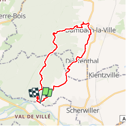
13 km | 18.5 km-effort
4h 38min
Yes
Trail Walking Châtenois - Le Hahnenberg et les balcons Sélestat - Photo
Walking
VacheKiri67

Walking

Medium
(2)
Châtenois, Grand Est, Bas-Rhin, France
12 km | 17.2 km-effort
4h 29min
Yes
Trail Walking Sélestat - Sentier de l'Illwald - Photo
Walking
tracegps

Walking

Medium
(1)
Sélestat, Grand Est, Bas-Rhin, France
13.2 km | 14.6 km-effort
3h 45min
Yes
Trail Walking Châtenois - Le Haut Koenigsbourg de Val de Ville - Photo
Walking
tracegps

Walking

Difficult
(1)
Châtenois, Grand Est, Bas-Rhin, France
16.8 km | 25 km-effort
5h 0min
Yes
Trail Mountain bike Thanvillé - Circuit de la Gadouille - Photo
Mountain bike
tracegps

Mountain bike

Difficult
(3)
Thanvillé, Grand Est, Bas-Rhin, France
18.4 km | 27 km-effort
1h 40min
Yes
Trail Walking Dambach-la-Ville - suuntoapp-Hiking-2023-12-26T08-42-47Z - Photo
Walking
GUIDE
holtzv

Walking

Very difficult
Dambach-la-Ville, Grand Est, Bas-Rhin, France
14.3 km | 21 km-effort
4h 43min
Yes
Trail Walking Kintzheim - suuntoapp-Hiking-2023-10-15T07-53-44Z - Photo
Walking
GUIDE
holtzv

Walking

Medium
Kintzheim, Grand Est, Bas-Rhin, France
18.5 km | 28 km-effort
6h 16min
Yes
Trail Walking Scherwiller - chateau  de ortenbourg - Photo
Walking
dudu42

Walking

Very easy
(1)
Scherwiller, Grand Est, Bas-Rhin, France
4.6 km | 7.9 km-effort
1h 29min
Yes
Trail Electric bike Sélestat - Vignoble  - Photo
Electric bike
apa

Electric bike

Very easy
Sélestat, Grand Est, Bas-Rhin, France
50 km | 57 km-effort
3h 4min
No


Close
My subscriptions