Trail Walking Sainte-Sabine-sur-Longève - Sainte-Sabine-sur-Longève - Photo
 Manoto
Manoto

User

© OpenStreetMap contributors
Length
Length
9.9 km
Max alt
Max alt
180 m
Uphill gradient
Uphill gradient
158 m
Km-Effort
Km-Effort  
12 km
Min alt
Min alt
87 m
Downhill gradient
Downhill gradient
156 m
Boucle
Boucle
Yes
Creation date :
2014-12-10 00:00:00.0
Updated on :
2014-12-10 00:00:00.0

(1 Reviews)

Walking
Walking
2h00
Difficulty : Easy

Scan this QR Code to open this trail in the SityTrail application

FREE GPS app for hiking

Logo SityTrail SityTrail

IGN / Geographical institutes

Download SityTrail from the App Store Download SityTrail from Google Play

Logo SityTrail SityTrail World

The world is yours!

Download SityTrail from the App Store Download SityTrail from Google Play Download SityTrail on Huawei AppGallery

About

Trail Walking of 9.9 km to be discovered at Pays de la Loire, Sarthe, Sainte-Sabine-sur-Longève. This trail is proposed by Manoto.

Description

Balisage violet

Elevation profile

Positioning

Country:
France
Region :
Pays de la Loire
Department/Province :
Sarthe
Municipality :
Sainte-Sabine-sur-Longève
Location:
Unknown
Start:(UTM)
283864 ; 5336030 (31U) N.

Comments

Please log in to post a review or rate the element


Trails nearby

Trail Walking Sainte-Sabine-sur-Longève - ST Sabine - Photo
Walking
uyuniness

Walking

Very easy
Sainte-Sabine-sur-Longève, Pays de la Loire, Sarthe, France
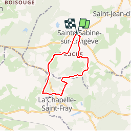
9.7 km | 11.7 km-effort
2h 0min
Yes
Trail Horseback riding La Chapelle-Saint-Fray - la chapelle/la bazoge - Photo
Horseback riding
xst

Horseback riding

Medium
(1)
La Chapelle-Saint-Fray, Pays de la Loire, Sarthe, France
20 km | 25 km-effort
3h 9min
Yes
Trail Mountain bike La Chapelle-Saint-Fray - la Bazoge - Photo
Mountain bike
xst

Mountain bike

Easy
La Chapelle-Saint-Fray, Pays de la Loire, Sarthe, France
15.9 km | 19.6 km-effort
2h 18min
Yes
Trail Mountain bike La Bazoge - Circuit du Roussard - La Bazoge - Photo
Mountain bike
tracegps

Mountain bike

Medium
La Bazoge, Pays de la Loire, Sarthe, France
23 km | 28 km-effort
1h 10min
Yes
Trail Walking La Bazoge - La Bazoge - Photo
Walking
Manoto

Walking

Very easy
(2)
La Bazoge, Pays de la Loire, Sarthe, France
15.5 km | 18.9 km-effort
Unknown
Yes
Trail Walking Mézières-sous-Lavardin - Mézières-sous-Lavardin - Photo
Walking
Manoto

Walking

Very easy
Mézières-sous-Lavardin, Pays de la Loire, Sarthe, France
12.7 km | 15.7 km-effort
Unknown
Yes
Trail Nordic walking Mézières-sous-Lavardin - Méziére - Photo
Nordic walking
clauderando

Nordic walking

Very easy
Mézières-sous-Lavardin, Pays de la Loire, Sarthe, France
10.5 km | 12.9 km-effort
2h 36min
Yes
Trail Walking La Chapelle-Saint-Fray - La chapelle St fray circuit bleu - Photo
Walking
mamyzine

Walking

Difficult
La Chapelle-Saint-Fray, Pays de la Loire, Sarthe, France
8.8 km | 11.5 km-effort
2h 44min
Yes
Trail Horseback riding La Chapelle-Saint-Fray - la chapelle.la bazoges - Photo
Horseback riding
xst

Horseback riding

Very easy
La Chapelle-Saint-Fray, Pays de la Loire, Sarthe, France
20 km | 25 km-effort
2h 53min
Yes


Close
My subscriptions