8.8 km | 10.9 km-effort
Pierrepont Rando vtt
dom54400
User
Length
13.5 km
Max alt
333 m
Uphill gradient
210 m
Km-Effort
16.3 km
Min alt
231 m
Downhill gradient
210 m
Boucle
Yes
Creation date :
2017-07-31 00:00:00.0
Updated on :
2017-07-31 00:00:00.0
1h05
Difficulty : Medium
FREE GPS app for hiking
About
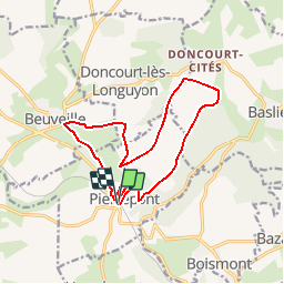
Trail Mountain bike of 13.5 km to be discovered at Grand Est, Meurthe-et-Moselle, Pierrepont. This trail is proposed by dom54400.
Description
Rando VTT Pierrepont et plaines Baslieux Doncourt, Beuveille
Positioning
Country:
France
Region :
Grand Est
Department/Province :
Meurthe-et-Moselle
Municipality :
Pierrepont
Location:
Unknown
Start:(Dec)
Start:(UTM)
696626 ; 5477120 (31U) N.
Comments
Trails nearby
L'arrière front allemand - Saint-Pierrevillers
Cycle
Difficult
Saint-Pierrevillers,
Grand Est,
Meuse,
France
46 km | 52 km-effort
3h 0min
Yes
DONCOURT 08-09-16
Walking
Medium
Doncourt-lès-Longuyon,
Grand Est,
Meurthe-et-Moselle,
France
10.5 km | 13.2 km-effort
2h 52min
Yes
BOISMONT 2023-12-21
Walking
Medium
Boismont,
Grand Est,
Meurthe-et-Moselle,
France
7.2 km | 8.3 km-effort
1h 42min
Yes
les convers
Walking
Medium
Montigny-sur-Chiers,
Grand Est,
Meurthe-et-Moselle,
France
8.4 km | 10.1 km-effort
2h 42min
Yes
Fermont
Walking
Medium
Viviers-sur-Chiers,
Grand Est,
Meurthe-et-Moselle,
France
9.6 km | 11.6 km-effort
2h 25min
No
Fermont 2023-04-27
Walking
Medium
Viviers-sur-Chiers,
Grand Est,
Meurthe-et-Moselle,
France
8.9 km | 10.7 km-effort
2h 21min
Yes
Boismont 2022-06-02
Walking
Easy
Boismont,
Grand Est,
Meurthe-et-Moselle,
France
9.8 km | 12 km-effort
2h 39min
Yes