Trail Walking Lavelanet - BOUCLE Ste Rufine, Raissac, Péreille d'en Bas et Haut, retour Cambière Bensa - Photo

BOUCLE Ste Rufine, Raissac, Péreille d'en Bas et Haut, retour Cambière Bensa

 jopost
jopost

User

© OpenStreetMap contributors
Length
Length
13.3 km
Max alt
Max alt
833 m
Uphill gradient
Uphill gradient
598 m
Km-Effort
Km-Effort  
21 km
Min alt
Min alt
519 m
Downhill gradient
Downhill gradient
597 m
Boucle
Boucle
Yes
Creation date :
2018-04-16 21:36:35.345
Updated on :
2021-06-07 18:09:49.61

(0 Reviews)

Walking
Walking
4h34
Difficulty : Easy

Scan this QR Code to open this trail in the SityTrail application

FREE GPS app for hiking

Logo SityTrail SityTrail

IGN / Geographical institutes

Download SityTrail from the App Store Download SityTrail from Google Play

Logo SityTrail SityTrail World

The world is yours!

Download SityTrail from the App Store Download SityTrail from Google Play Download SityTrail on Huawei AppGallery

About

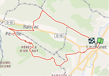
Trail Walking of 13.3 km to be discovered at Occitania, Ariège, Lavelanet. This trail is proposed by jopost.

Description

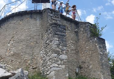
boucle rando-touristique des Croix, Chapelles et Églises.
Départ du Rond-point vers l'ancienne chapelle Ste Rufine continuez sur la crête et tournez à gauche vers l'église de Raissac, puis allez à la croix de Péreille et vers l'église de Péreille d'en bas, revenez et tournez à droite vers Péreille d'en Haut, passez devant la stèle des maquisarts et continuez vers Rabaute, n'oubliez pas de tourner vers Cambière (croix mais allez à gauche) retour en visitant la chapelle de Bensa puis revenez au rond point par la rue Pasteur

Elevation profile

Photos

Positioning

Country:
France
Region :
Occitania
Department/Province :
Ariège
Municipality :
Lavelanet
Location:
Unknown
Start:(UTM)
406040 ; 4754003 (31T) N.

Trails nearby

Trail Electric bike Lavelanet - Lavelanet Ste Colombe lac Montbel retour Laroque  - Photo
Electric bike
jopost

Electric bike

Medium
Lavelanet, Occitania, Ariège, France
40 km | 44 km-effort
4h 30min
Yes
Trail On foot Laroque-d'Olmes - Les Crètes du Plantaurel - Photo
On foot
PRO

On foot

Easy
Laroque-d'Olmes, Occitania, Ariège, France
11.8 km | 17.3 km-effort
3h 55min
Yes
Trail Walking Montferrier - découverte du château de montsegur et du village par montferroer - Photo
Walking
fab0202

Walking

Medium
Montferrier, Occitania, Ariège, France
12.6 km | 21 km-effort
3h 42min
Yes
Trail Walking Lavelanet - Camping Village des Bons-Hommes pour balade-grillade - Photo
Walking
jopost

Walking

Very easy
Lavelanet, Occitania, Ariège, France
4.8 km | 6.5 km-effort
2h 14min
Yes
Trail Walking Montferrier - Sentier cathare - Château de Montsegur - Photo
Walking
toutankhcarton

Walking

Medium
Montferrier, Occitania, Ariège, France
12.6 km | 21 km-effort
4h 48min
Yes
Trail Walking Lavelanet - boucle soula le bac  - Photo
Walking
jopost

Walking

Difficult
Lavelanet, Occitania, Ariège, France
7.3 km | 10.8 km-effort
3h 13min
Yes
Trail Walking Lavelanet - Tour de Péreille - Photo
Walking
RR31

Walking

Very easy
Lavelanet, Occitania, Ariège, France
14.7 km | 19.1 km-effort
4h 3min
Yes
Trail Walking Lavelanet - Lavelanet Belesta Ivry - Photo
Walking
RR31

Walking

Medium
Lavelanet, Occitania, Ariège, France
25 km | 32 km-effort
6h 42min
No
Trail Mountain bike Lavelanet - Grande Traversée VTT FFC Ariège Pyrénées - Etape 4 - Lavelanet - Chalabre - Photo
Mountain bike
tracegps

Mountain bike

Easy
Lavelanet, Occitania, Ariège, France
18.3 km | 20 km-effort
1h 19min
No


Close
My subscriptions