Trail Walking Cros - Le Pouget- Mas de Boissière  - Photo

Le Pouget- Mas de Boissière

© OpenStreetMap contributors
Length
Length
9.5 km
Max alt
Max alt
608 m
Uphill gradient
Uphill gradient
365 m
Km-Effort
Km-Effort  
14.4 km
Min alt
Min alt
245 m
Downhill gradient
Downhill gradient
363 m
Boucle
Boucle
Yes
Creation date :
2018-04-16 23:54:11.79
Updated on :
2018-04-16 23:54:11.79

(0 Reviews)

Walking
Walking
2h29
Difficulty : Easy

Scan this QR Code to open this trail in the SityTrail application

FREE GPS app for hiking

Logo SityTrail SityTrail

IGN / Geographical institutes

Download SityTrail from the App Store Download SityTrail from Google Play

Logo SityTrail SityTrail World

The world is yours!

Download SityTrail from the App Store Download SityTrail from Google Play Download SityTrail on Huawei AppGallery

About

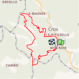
Trail Walking of 9.5 km to be discovered at Occitania, Gard, Cros. This trail is proposed by zoe.vienne.

Description

À trois km au nord de St Hippolyte du Fort, boucle faite le 1er Octobre 2017 dans le sens inverse des aiguilles d'une montre, ce qui donne une longue montée sur une large piste forestière et une descente plus raide dans un chemin caillouteux. Peut être qu'en sens inverse cette randonnée aurait plus d'intérêt. Sinon, belle vue sur les Jumelles et beau paysage d'automne.

Elevation profile

Photos

Positioning

Country:
France
Region :
Occitania
Department/Province :
Gard
Municipality :
Cros
Location:
Unknown
Start:(UTM)
566404 ; 4870566 (31T) N.

Trails nearby

Trail Walking La Cadière-et-Cambo - CAMBO - MONTAGNE DE LA FAGE - 7.6Km - 02h20 - Dénivelé 285 m - Photo
Walking
dansmabulle

Walking

Medium
(1)
La Cadière-et-Cambo, Occitania, Gard, France
7.6 km | 11.2 km-effort
2h 29min
Yes
Trail On foot Colognac - 30 du Cayrel au Camp Barrat 20/02/24 - Photo
On foot
silvestreclaudine

On foot

Medium
Colognac, Occitania, Gard, France
16 km | 25 km-effort
5h 38min
Yes
Trail Walking Sumène - 30 les crêtes des cagnasses,a la fage 15/11/23 - Photo
Walking
silvestreclaudine

Walking

Very difficult
Sumène, Occitania, Gard, France
17 km | 26 km-effort
5h 13min
Yes
Trail Walking Saint-Roman-de-Codières - st roman de codieres - Photo
Walking
toinou30

Walking

Medium
Saint-Roman-de-Codières, Occitania, Gard, France
16.2 km | 24 km-effort
6h 11min
Yes
Trail Road bike Saint-Hippolyte-du-Fort - St hippolyte Sumène  - Photo
Road bike
GUIDE
Roger Philippe Wallez

Road bike

Very difficult
Saint-Hippolyte-du-Fort, Occitania, Gard, France
46 km | 54 km-effort
3h 18min
Yes
Trail Walking Saint-Hippolyte-du-Fort - 30  Roquefourcade 16-03_23 - Photo
Walking
silvestreclaudine

Walking

Very difficult
Saint-Hippolyte-du-Fort, Occitania, Gard, France
17.1 km | 24 km-effort
6h 37min
Yes
Trail Walking Saint-Roman-de-Codières - St Roman de Codiere 2 - Photo
Walking
guyzinz

Walking

Medium
Saint-Roman-de-Codières, Occitania, Gard, France
13.7 km | 20 km-effort
4h 36min
Yes
Trail Walking Sumène - Cézas Prieuré St Martin - Photo
Walking
LBarel

Walking

Medium
Sumène, Occitania, Gard, France
6.2 km | 9.5 km-effort
2h 25min
Yes
Trail Walking Saint-Roman-de-Codières - St Roman de Codiere - Photo
Walking
guyzinz

Walking

Medium
(1)
Saint-Roman-de-Codières, Occitania, Gard, France
14.1 km | 21 km-effort
4h 15min
Yes


Close
My subscriptions