Trail Walking Bourron-Marlotte - Grez Nemours - Photo
 gal75len
gal75len

User

© OpenStreetMap contributors
Length
Length
24 km
Max alt
Max alt
123 m
Uphill gradient
Uphill gradient
269 m
Km-Effort
Km-Effort  
28 km
Min alt
Min alt
54 m
Downhill gradient
Downhill gradient
279 m
Boucle
Boucle
No
Creation date :
2018-04-17 13:09:27.459
Updated on :
2019-05-28 16:59:37.782

(1 Reviews)

Walking
Walking
6h52
Difficulty : Unknown

Scan this QR Code to open this trail in the SityTrail application

FREE GPS app for hiking

Logo SityTrail SityTrail

IGN / Geographical institutes

Download SityTrail from the App Store Download SityTrail from Google Play

Logo SityTrail SityTrail World

The world is yours!

Download SityTrail from the App Store Download SityTrail from Google Play Download SityTrail on Huawei AppGallery

About

Trail Walking of 24 km to be discovered at Ile-de-France, Seine-et-Marne, Bourron-Marlotte. This trail is proposed by gal75len.

Elevation profile

Positioning

Country:
France
Region :
Ile-de-France
Department/Province :
Seine-et-Marne
Municipality :
Bourron-Marlotte
Location:
Unknown
Start:(UTM)
477222 ; 5353340 (31U) N.

Comments

Please log in to post a review or rate the element


Belle rando surtout en automne


Trails nearby

Trail Walking Fontainebleau - GLM-150311 - PVerte-Fourceau-Béatrix - Photo
Walking
randodan

Walking

Medium
(1)
Fontainebleau, Ile-de-France, Seine-et-Marne, France
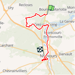
16.5 km | 20 km-effort
6h 0min
Yes
Trail Walking Fontainebleau - Rocher Fourceau-Petit Mont Chauvet SR210523Ve?? fmg - Photo
Walking
fmg

Walking

Very difficult
(1)
Fontainebleau, Ile-de-France, Seine-et-Marne, France
19.5 km | 24 km-effort
5h 27min
Yes
Trail On foot La Genevraye - Du canal du Loing au berges du Lunain - Photo
On foot
PRO

On foot

Easy
La Genevraye, Ile-de-France, Seine-et-Marne, France
5.1 km | 5.5 km-effort
1h 15min
No
Trail Walking Fontainebleau - Fontainebleau tour est - Photo
Walking

Walking

Difficult
(4)
Fontainebleau, Ile-de-France, Seine-et-Marne, France
22 km | 27 km-effort
6h 10min
Yes
Trail Walking Villiers-sous-Grez - Villiers sous grez / Larchant - Photo
Walking
becor94

Walking

Very difficult
Villiers-sous-Grez, Ile-de-France, Seine-et-Marne, France
24 km | 29 km-effort
5h 31min
Yes
Trail Walking Recloses - Recloses Ve120124 pm - Photo
Walking
fmg

Walking

Medium
(1)
Recloses, Ile-de-France, Seine-et-Marne, France
8.9 km | 10.5 km-effort
2h 23min
Yes
Trail Walking Recloses - Recloses ve 120124 am - Photo
Walking
fmg

Walking

Medium
(1)
Recloses, Ile-de-France, Seine-et-Marne, France
10.8 km | 12.6 km-effort
2h 52min
Yes
Trail Walking Recloses - Boucle recloses Nemours Grez/loing - Photo
Walking
chessyca

Walking

Medium
(1)
Recloses, Ile-de-France, Seine-et-Marne, France
30 km | 34 km-effort
6h 20min
Yes
Trail On foot Bourron-Marlotte - Boucle 30 km Bourron Marlotte - Montigny/ Loing / Grez - Photo
On foot
chessyca

On foot

Difficult
Bourron-Marlotte, Ile-de-France, Seine-et-Marne, France
28 km | 32 km-effort
7h 14min
Yes


Close
My subscriptions