Trail Walking La Faurie - R40   Les Marmites du Diable - Photo

Les Hautes Alpes à découvrir ! GUIDE+

© OpenStreetMap contributors
Length
Length
5.9 km
Max alt
Max alt
1178 m
Uphill gradient
Uphill gradient
341 m
Km-Effort
Km-Effort  
10.4 km
Min alt
Min alt
838 m
Downhill gradient
Downhill gradient
341 m
Boucle
Boucle
Yes
Creation date :
2018-03-23 05:41:00.281
Updated on :
2018-10-17 06:40:31.811

(6 Reviews)

Walking
Walking
2h07
Difficulty : Medium

Scan this QR Code to open this trail in the SityTrail application

FREE GPS app for hiking

Logo SityTrail SityTrail

IGN / Geographical institutes

Download SityTrail from the App Store Download SityTrail from Google Play

Logo SityTrail SityTrail World

The world is yours!

Download SityTrail from the App Store Download SityTrail from Google Play Download SityTrail on Huawei AppGallery

About

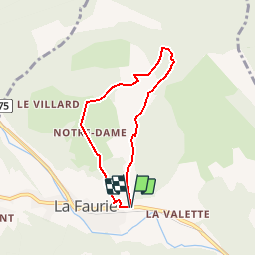
Trail Walking of 5.9 km to be discovered at Provence-Alpes-Côte d'Azur, Hautes-Alpes, La Faurie. This trail is proposed by Camping Les Rives du Lac.

Description

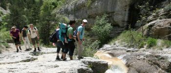
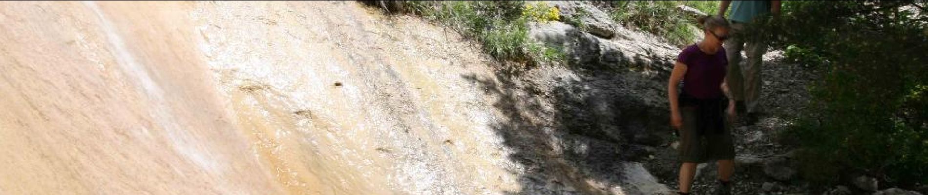
A varied hike, starting along the pots (where you can swim), then crossing a forest before accessing a track. On the way down, you can stop at the Orthodox Monastery of Notre Dame. In summer, avoid Saturday because the traffic is dense on the road to Grenoble. It is particularly in this stream that our guides introduce children and beginners to canyoning. A steep part to climb, be careful not to slip.

Elevation profile

Photos

Points of interest

Point of interest La Faurie - Départ Marmites du diable - Photo
CampingLesRivesduLac
Point of interest La Faurie - Marmites du diable - Photo
CampingLesRivesduLac

Positioning

Country:
France
Region :
Provence-Alpes-Côte d'Azur
Department/Province :
Hautes-Alpes
Municipality :
La Faurie
Location:
Unknown
Start:(UTM)
718200 ; 4938550 (31T) N.

Comments

Please log in to post a review or rate the element


Hele mooie wandeling! Met een gezin gelopen van 8, 10 en 11 jaar. Je moet voor deze wandeling goed zelf kunnen lopen. Het is een pittige klim langs smalle paden. Je loopt langs mooie riviertjes. Terug weg is een flinke daling op een brede pad. Goede schoenen met grip is wel van belang tijdens de wandeling. Wij zijn rond 10:00u vertrokken en liepen tijdens de klim in de schaduw, tijdens het dalen liepen we in de zon.


Très chouette! Bien indiqué et aménagé. Faite en mai, il nous a fallu déchausser plusieurs fois pour traverser la rivière mais en plein été il doit y avoir moins d’eau. Petit bonhomme de 4 ans a fait toute la montée et redescendu en porte bébé. La montée est escarpée, il faut mettre les mains, s’accrocher aux câbles et c’est ça qui est rigolo pour les enfants aventuriers. En revanche j’avoue qu’il faut que les parents soient assez confiants car il y a des passages délicats. Évidemment, on a mis plus de temps que prévu mais c’était prévu! Tout ça pour dire que ça se fait en dessous de 10 ans, ça dépend des enfants et des parents :)


Très belle balade mais très technique sur la montée. Ne surtout pas faire avec des enfants de moins de 10 ans.


Très belle rando ! Des passages raides dans la montée.


Beautiful! Wouldn't advise to do this trail with kids under 10.


Trails nearby

Trail Walking Aspres-sur-Buëch - R42   La Longeagne - Photo
Walking
GUIDE+

Walking

Very easy
(1)
Aspres-sur-Buëch, Provence-Alpes-Côte d'Azur, Hautes-Alpes, France
7.1 km | 11.2 km-effort
2h 23min
Yes
Trail On foot Aspres-sur-Buëch - 9587028 - Photo
On foot
GUIDE+

On foot

Easy
Aspres-sur-Buëch, Provence-Alpes-Côte d'Azur, Hautes-Alpes, France
3.4 km | 5.3 km-effort
1h 12min
Yes
Trail Running Aspres-sur-Buëch - Trail 06 - La Longeagne - Photo
Running
GUIDE+

Running

Difficult
Aspres-sur-Buëch, Provence-Alpes-Côte d'Azur, Hautes-Alpes, France
9.7 km | 19.1 km-effort
2h 0min
Yes
Trail Mountain bike Aspres-sur-Buëch - Gorges de l'Agnielle - Photo
Mountain bike
jeanboulay

Mountain bike

Medium
Aspres-sur-Buëch, Provence-Alpes-Côte d'Azur, Hautes-Alpes, France
12 km | 16.7 km-effort
2h 25min
Yes
Trail Mountain bike Saint-Pierre-d'Argençon - HA J3 long - Photo
Mountain bike
thierryd

Mountain bike

Very easy
(4)
Saint-Pierre-d'Argençon, Provence-Alpes-Côte d'Azur, Hautes-Alpes, France
34 km | 42 km-effort
2h 45min
No
Trail Walking La Faurie - SityTrail - SityTrail - La Vallette - Agnielles - Marmites du Diable - Photo
Walking
kurt-vh

Walking

Very difficult
La Faurie, Provence-Alpes-Côte d'Azur, Hautes-Alpes, France
15.6 km | 28 km-effort
6h 15min
Yes
Trail Walking Aspres-sur-Buëch - Montagne Saint-Apôtre  - Photo
Walking
PapouBertrand

Walking

Very difficult
Aspres-sur-Buëch, Provence-Alpes-Côte d'Azur, Hautes-Alpes, France
9.9 km | 19.4 km-effort
5h 17min
Yes
Trail Walking Veynes - Champi - Photo
Walking
jlv05

Walking

Very easy
Veynes, Provence-Alpes-Côte d'Azur, Hautes-Alpes, France
10.8 km | 13.7 km-effort
1h 54min
No
Trail Walking Aspres-sur-Buëch - col de seille  - Photo
Walking
tyax93

Walking

Easy
Aspres-sur-Buëch, Provence-Alpes-Côte d'Azur, Hautes-Alpes, France
4.2 km | 8.2 km-effort
1h 44min
No


Close
My subscriptions