Trail Walking Plan-d'Aups-Sainte-Baume - 83 ste baume grotte aux oeufs et elie cabre - Photo

83 ste baume grotte aux oeufs et elie cabre

© OpenStreetMap contributors
Length
Length
11.7 km
Max alt
Max alt
1028 m
Uphill gradient
Uphill gradient
453 m
Km-Effort
Km-Effort  
17.6 km
Min alt
Min alt
667 m
Downhill gradient
Downhill gradient
421 m
Boucle
Boucle
No
Creation date :
2018-04-17 19:19:22.731
Updated on :
2018-04-17 19:19:22.731

(0 Reviews)

Walking
Walking
5h48
Difficulty : Unknown

Scan this QR Code to open this trail in the SityTrail application

FREE GPS app for hiking

Logo SityTrail SityTrail

IGN / Geographical institutes

Download SityTrail from the App Store Download SityTrail from Google Play

Logo SityTrail SityTrail World

The world is yours!

Download SityTrail from the App Store Download SityTrail from Google Play Download SityTrail on Huawei AppGallery

About

Trail Walking of 11.7 km to be discovered at Provence-Alpes-Côte d'Azur, Var, Plan-d'Aups-Sainte-Baume. This trail is proposed by himba26100.

Description

jp joelle 18 02 18

Elevation profile

Points of interest

Point of interest Plan-d'Aups-Sainte-Baume - Point 1 - Photo
himba26100
PLAN-D'AUPS-SAINTE-BAUME 
Point of interest Plan-d'Aups-Sainte-Baume - Point 2 - Photo
himba26100
PLAN-D'AUPS-SAINTE-BAUME 

Positioning

Country:
France
Region :
Provence-Alpes-Côte d'Azur
Department/Province :
Var
Municipality :
Plan-d'Aups-Sainte-Baume
Location:
Unknown
Start:(UTM)
723445 ; 4801773 (31T) N.

Trails nearby

Trail Walking Plan-d'Aups-Sainte-Baume - Sainte Baume 8,5 km - Photo
Walking
GUIDE
rvapeldo

Walking

Medium
(1)
Plan-d'Aups-Sainte-Baume, Provence-Alpes-Côte d'Azur, Var, France
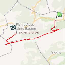
8.4 km | 15.5 km-effort
4h 38min
Yes
Trail Walking Nans-les-Pins - Le baou des glacières - Photo
Walking
GUIDE
amiral13

Walking

Medium
(1)
Nans-les-Pins, Provence-Alpes-Côte d'Azur, Var, France
7.6 km | 12.2 km-effort
4h 27min
Yes
Trail Walking Plan-d'Aups-Sainte-Baume - SityTrail - Sentier merveilleux - La Ste baume - Le Plan d'aups  - Photo
Walking
GUIDE
affinetataille

Walking

Medium
(1)
Plan-d'Aups-Sainte-Baume, Provence-Alpes-Côte d'Azur, Var, France
15 km | 23 km-effort
6h 0min
Yes
Trail Walking Plan-d'Aups-Sainte-Baume - Crêts de la Ste Baume - Photo
Walking
tracegps

Walking

Medium
(2)
Plan-d'Aups-Sainte-Baume, Provence-Alpes-Côte d'Azur, Var, France
15.4 km | 23 km-effort
5h 0min
Yes
Trail Walking Nans-les-Pins - La Croix des Glacières, Sainte-Baume - Photo
Walking
tracegps

Walking

Medium
(1)
Nans-les-Pins, Provence-Alpes-Côte d'Azur, Var, France
7.2 km | 12 km-effort
3h 19min
Yes
Trail Walking Plan-d'Aups-Sainte-Baume - Du Col du Saint-Pilon au Pas de l'Aï, Sainte Baume - Photo
Walking
tracegps

Walking

Medium
(1)
Plan-d'Aups-Sainte-Baume, Provence-Alpes-Côte d'Azur, Var, France
13.1 km | 20 km-effort
5h 15min
Yes
Trail Walking Riboux - Riboux - Forêt de Malaucène - Photo
Walking
tracegps

Walking

Medium
(4)
Riboux, Provence-Alpes-Côte d'Azur, Var, France
12.2 km | 15.2 km-effort
2h 40min
Yes
Trail Walking Plan-d'Aups-Sainte-Baume - La Grotte aux oiseaux - Plan d'Aups  - Photo
Walking
tracegps

Walking

Medium
(1)
Plan-d'Aups-Sainte-Baume, Provence-Alpes-Côte d'Azur, Var, France
8.8 km | 12.5 km-effort
2h 30min
Yes
Trail On foot Plan-d'Aups-Sainte-Baume - Massif Sainte Baume et pas de l’Aï 15 km - Photo
On foot
GUIDE
rvapeldo

On foot

Medium
Plan-d'Aups-Sainte-Baume, Provence-Alpes-Côte d'Azur, Var, France
15 km | 22 km-effort
5h 0min
Yes


Close
My subscriptions