Trail Walking Bonnes - Bonnes 16 - Photo
 bert16
bert16

User

© OpenStreetMap contributors
Length
Length
8.2 km
Max alt
Max alt
125 m
Uphill gradient
Uphill gradient
132 m
Km-Effort
Km-Effort  
10 km
Min alt
Min alt
41 m
Downhill gradient
Downhill gradient
132 m
Boucle
Boucle
Yes
Creation date :
2018-04-17 19:33:14.38
Updated on :
2018-04-17 19:33:14.38

(0 Reviews)

Walking
Walking
2h10
Difficulty : Easy

Scan this QR Code to open this trail in the SityTrail application

FREE GPS app for hiking

Logo SityTrail SityTrail

IGN / Geographical institutes

Download SityTrail from the App Store Download SityTrail from Google Play

Logo SityTrail SityTrail World

The world is yours!

Download SityTrail from the App Store Download SityTrail from Google Play Download SityTrail on Huawei AppGallery

About

Trail Walking of 8.2 km to be discovered at New Aquitaine, Charente, Bonnes. This trail is proposed by bert16.

Description

20/02/2018. 10 randonneurs de l'Association des anciens élèves et amis de Brie-sous-chalais 16210

Elevation profile

Positioning

Country:
France
Region :
New Aquitaine
Department/Province :
Charente
Municipality :
Bonnes
Location:
Unknown
Start:(UTM)
276215 ; 5013445 (31T) N.

Trails nearby

Trail On foot Les Essards - Les Essards Yellow Route - Photo
On foot
PRO

On foot

Easy
Les Essards, New Aquitaine, Charente, France
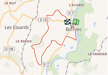
7.7 km | 9.7 km-effort
2h 11min
Yes
Trail Walking Laprade - Laprade - Photo
Walking
dorcier

Walking

Easy
Laprade, New Aquitaine, Charente, France
11.3 km | 13.1 km-effort
2h 51min
Yes
Trail On foot Rouffiac - Circuit des trois Églises - Photo
On foot
PRO

On foot

Easy
Rouffiac, New Aquitaine, Charente, France
11.7 km | 15.9 km-effort
3h 36min
Yes
Trail On foot Les Essards - Les Essards Blue Route - Photo
On foot
PRO

On foot

Easy
Les Essards, New Aquitaine, Charente, France
9 km | 11.5 km-effort
2h 37min
Yes
Trail On foot Les Essards - Les Essards Red Route - Photo
On foot
PRO

On foot

Easy
Les Essards, New Aquitaine, Charente, France
6.1 km | 7.7 km-effort
1h 45min
No
Trail Walking Saint-Romain - saint-romain 16 03 sept 2019 - Photo
Walking
bert16

Walking

Medium
Saint-Romain, New Aquitaine, Charente, France
7.8 km | 9.5 km-effort
1h 57min
Yes
Trail Walking Aubeterre-sur-Dronne - Aubeterre-Poltrot 28 juin 2018 - Photo
Walking
bert16

Walking

Easy
(1)
Aubeterre-sur-Dronne, New Aquitaine, Charente, France
11.2 km | 13.9 km-effort
3h 0min
Yes
Trail Walking Aubeterre-sur-Dronne - dom - Photo
Walking
bert16

Walking

Easy
Aubeterre-sur-Dronne, New Aquitaine, Charente, France
27 km | 33 km-effort
3h 14min
No
Trail Cycle Saint-Aulaye-Puymangou - St Aulaye - Photo
Cycle
tracegps

Cycle

Medium
Saint-Aulaye-Puymangou, New Aquitaine, Dordogne, France
12.7 km | 14.9 km-effort
2h 0min
Yes


Close
My subscriptions